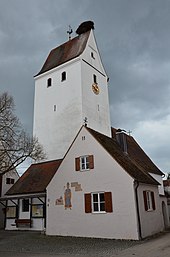
Ensemble Rudelstetten
The Rudelstetten ensemble includes the historically built-up area of Rudelstetten , a district of the municipality of Alerheim in the Swabian district of Donau-Ries in Bavaria . The ensemble is a protected architectural monument .
description

The ensemble encompasses the area of Angers formed by the extension of the thoroughfare and its adjacent buildings. Rudelstetten lies to the east along an oxbow arm of the Wörnitz and, as an anger village, extends mainly in a north-westerly direction. The Anger develops in the south from a street narrowing and a street curve, in the slight oscillation of which the gable fronts of the residential stalls align themselves through a slight axis shift, then widens and lets the houses lined up on both sides of the street recede far back.
Rudelstetten is an example of a typical Rieser village . It shows the characteristic features of ground-floor buildings with horseshoe-shaped courtyards , with the row of gable-free stable houses at relatively equal intervals on both sides of the Angers a specific expression of the structural continuity. The farmhouse in the shape of angled hooks, which is characteristic of the region, is created by the barn, which is set back at right angles to the gable-facing residential stable house . A fence towards the street is made by demarcating fences between the gabled houses.
The Evangelical Lutheran Church of St. Ulrich is on the west side of the cemetery .
The unadorned, smooth plastered farmhouse with its low gable is characteristic of the village. Most of the buildings date from the second half of the 19th century. The two-storey houses nos. 15 and 35 form a disruption within the Rieser Angerdort type.
literature
- Bernd-Peter Schaul: Swabia . Ed .: Michael Petzet , Bavarian State Office for the Preservation of Monuments (= Monuments in Bavaria . Volume VII ). Oldenbourg, Munich 1986, ISBN 3-486-52398-8 , pp. 179 .
Web links
Coordinates: 48 ° 51 ′ 18.5 ″ N , 10 ° 38 ′ 33.9 ″ E
