Ores
|
Ores Erzeni |
||
|
The river west of the breakthrough through the mountains at Iba |
||
| Data | ||
| location | Albania | |
| River system | Ores | |
| origin | Confluence of the source streams at Shëngjergj e Shënmëri 41 ° 19 '37 " N , 20 ° 4' 47" O |
|
| Source height | approx. 1200 m above sea level A. | |
| muzzle | in the Adriatic Bay Gjiri i Lalzit Coordinates: 41 ° 26 ′ 13 " N , 19 ° 27 ′ 35" E 41 ° 26 ′ 13 " N , 19 ° 27 ′ 35" E
|
|
| length | 109 km | |
| Catchment area | 760 km² | |
|
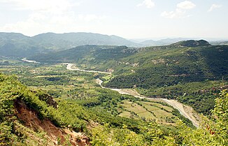
Erzen Valley south of Tirana seen from Petrela Castle |
||
|
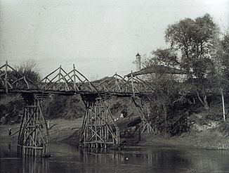
Erzen Bridge near Shijak around 1914 |
||
The Erzen ( Albanian also Erzeni ) is a river in central Albania . It rises around 25 kilometers east of Tirana near the Mali me Gropa and flows northwest of the Albanian capital into the Adriatic . Its length is 109 kilometers. It drains the eastern tip and the whole south of Tirana County and the east of Durrës County , a total of 760 square kilometers.
The source of the ore is around 1200 m above sea level. A. in a large basin in the Skanderbeg Mountains . In the village of Shëngjergj e Shënmëri, various other sources feed the young river. South of the Dajti or Mali i Priskës , the Erzen breaks through the outer edge chain, the Kruja chain, in a deeply cut gorge (Gryka e Skronës) . A hold-up weir regulates the influence in the gorge and prevents excessive runoff by means of a small reservoir.
As a result, it flows to the west at the northern foot of the Kodrat e Krrabës (Krraba hills) . The valley floor, in which it meanders from one side to the other , is usually around one kilometer wide from the point where it emerges from the marginal chain.
The river passes the city of Tirana just a few kilometers from its southern foothills. Only a small range of hills separates the valley of the Erzen from the plain of Tirana with the rivers Lana , Tirana (Lumi i Tiranës) , Zeza and Tërkuza , which unite in Ishëm . On the southwestern outskirts near Yzberisht , the transition from the plain to the Erzen Valley is barely noticeable.
To the southwest of Tirana the Erzen breaks through the Kodra e Gjatë (long hills) . Then its course turns north , just a few kilometers from the sea at the Bay of Durrës . It runs parallel to the Kodra e Gjatë and the coast at Shijak through a wide plain. The mouth lies between Durrës and the headland of Cape Rodon on the wide bay of Gjiri i Lalzit . The average flow rate at the mouth is 18.1 m³ / s, with the highest flow rate exceeding the annual minimum by eleven times.
Surname
The river was known as Ardaxanus in ancient times , from which the current Albanian name form developed. It was named Ersenta from 1308 , which is already similar to today's name. But in 1591 Arsenta was also used.
Web links
Individual evidence
- ↑ a b c d e Alqiviadh Cullaj, Agim Hasko, Aleko Miho, Ferdinand Schanz, Helmut Brandl, Reinhard Bachofen: The quality of Albanian natural waters and the human impact , in: Environment International 31 (2005)
- ↑ Shtegtim në ores on YouTube
- ↑ Robert Elsie : Hydronymica Albanica . In: Journal of Balkanology . 2nd, revised edition. 2014, p. 12 (English, first edition: 1994).


