
2015 Coquimbo earthquake
| 2015 Coquimbo earthquake | |||
|---|---|---|---|
|
|||
| Coordinates | 31 ° 34 ′ 23 " S , 71 ° 40 ′ 26" W | ||
| date | 16th September 2015 | ||
| Time | 22:54:33 (UTC) | ||
| intensity | VIII on the MM scale | ||
| Magnitude | 8.3 M W | ||
| depth | 22.4 km | ||
| epicenter | 46 km
(Illapel, Chile)
|
||
| country | Chile | ||
| Affected places |
Illapel |
||
| Tsunami | Yes | ||
| dead | 16 | ||
| Injured | 20+ | ||

The 2015 Coquimbo earthquake was a megathrust earthquake with an epicenter in the southern Pacific Ocean 46 km off Illapel , Chile on September 16 at 19:54:33 Chilean time (22:54:33 UTC ) with a moment magnitude of 8, 3. It was caused by a thrust along the border between the Nazca and South American plates . Four strong aftershocks have occurred since then.
Effects and Consequences
According to the Chilean government, 15 people were killed and dozens injured. On September 18, 1560 victims were named. In Argentina , a man suffered a heart attack while evacuating his home. A tsunami was triggered, which is why the Pacific Tsunami Warning Center in Honolulu, Hawaii issued warnings and notices for the entire Pacific region for Ecuador, Peru, New Zealand, Fiji, the Solomon Islands, Hawaii and California. A wave up to 4.5 m high was observed along the coasts of the Región de Coquimbo , and the cities of Coquimbo , Tongoy and Concón reported flooding. The Chilean authorities ordered the immediate evacuation of the coastal areas. One million people across the country were affected by this evacuation.
Illapel reported the loss of electricity and drinking water. Tall buildings still swayed in Buenos Aires, 1,100 km from the epicenter .
Tectonic overview

The earthquake with a magnitude of 8.3 on September 16, 2015 west of Illapel, Chile, occurred as a result of a thrust on the border between the Nazca plate and the South American plate in central Chile. At this latitude, the Naczaplatte moved in relation to the South American plate at a rate of 74 mm / year east-northeast and starts subduction under the continent Atacama trench of the epicenter, about 85 km west of the earthquake of 16 September. The size, location and mechanism of the earthquake event are consistent with the thrust in this region.
While earthquakes of this size are usually marked as dots on maps, the plates actually slide over a larger portion of the plate boundary. Earthquakes of the current size typically cover an area 230 km long and 100 km wide.
Chile has a long history of major earthquakes, most recently the earthquake in spring 2010 with a magnitude of 8.8, which led to severe destruction in central Chile south of the present event with over 500 deaths and an approximately 400 km long section of the plate boundary south of the Juan Fernández Ridge , which reaches the Atacama Trench just south of the epicenter of the 2015 earthquake. The largest earthquake recorded so far worldwide also occurred in this subduction zone, the 1960 earthquake in Valdivia in southern Chile. In the one hundred years before the event of September 16, 2015, there were 15 further earthquakes with magnitudes above 7 within 400 km of its epicenter.
Chile is located in one of the most seismically active areas on earth. An earthquake with a magnitude of 8.2 occurred not far from Iquique in 2014 .
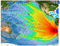
Tsunami

The Pacific Tsunami Warning Center (PTWC) of the National Oceanic and Atmospheric Administration (NOOA) issued the first warning of a destructive tsunami for the coasts of Chile and Peru six minutes after the earthquake. The PTWC later announced that it was expecting a tsunami in Chile with a local height of more than three meters and a height between one and three meters above the normal tidal water level for some coasts in French Polynesia . The PTWC calculated a tsunami between 0.3 and 1 m for other stretches of coast in South America and Oceania. For all other coasts of the Pacific Ocean, the height of the tsunami was expected to be less than 0.3 m.
Picture gallery

earthquake

Tsunami
Tsunami

Tsunami


See also
supporting documents
- ↑ a b c d e f g M 8.3 - 48km W of Illapel, Chile ( English ) United States Geological Survey. Retrieved January 11, 2020.
- ↑ Strong quake shakes Chile capital, causing buildings to sway (English) . 16th September 2015.
- ↑ M8.3 - 46km W of Illapel, Chile ( English ) United States Geological Survey . September 16, 2015. Accessed September 17, 2015.
- ↑ M6.3 - 71km W of Illapel, Chile ( English ) United States Geological Survey . Retrieved September 17, 2015.
- ↑ M6.1 - 44km WSW of Illapel, Chile ( English ) United States Geological Survey . Retrieved September 17, 2015.
- ↑ M6.2 - 70km W of Illapel, Chile ( English ) United States Geological Survey . Retrieved September 17, 2015.
- ↑ M6.4 - 25km W of Illapel, Chile ( English ) United States Geological Survey . Retrieved September 17, 2015.
- ↑ Monitoreo por Sismo de Mayor Intensidad. In: onemi.gov.cl . October 24, 2015, accessed January 11, 2020 (Spanish).
- ↑ Grupo Copesa: Onemi: aumentan a 13 los muertos ya seis los desaparecidos. In: latercera.com. September 18, 2015, archived from the original on October 7, 2015 ; Retrieved February 7, 2016 (Spanish).
- ↑ Terremoto en Chile que se sintió en la ArgentinaSe asustó por el temblor, sufrió un infarto y murió. In: clarin.com . September 17, 2015, accessed January 11, 2020 (Spanish).
- ↑ a b c d Ben Doherty: Tsunami warnings across Pacific after magnitude 8.3 earthquake hits Chile ( English ) In: The Guardian . Retrieved September 17, 2015.
- ^ Pascale Bonnefoy: Chile Earthquake Strikes Coast, Forcing Residents to Evacuate (English) . In: The New York Times , September 16, 2015. Retrieved September 17, 2015.
- ^ Tsunami warning after powerful earthquake hits Chile . In: Collie Mail , September 17, 2015.
- ↑ Strong Chile earthquake sets off tsunami waves ( English ) BBC News . Retrieved September 17, 2015.
- ^ Pacific Tsunami Warning Center : Tsunami Message Number 1 ( English ) National Oceanic and Atmospheric Administration. September 16, 2015. Accessed September 17, 2015.
- ^ Pacific Tsunami Center: Tsunami Message Number 11 ( English ) National Oceanic and Atmospheric Administration. September 17, 2015. Retrieved September 17, 2015.