
List of earthquakes in Chile

The list of earthquakes in Chile shows all relevant earthquakes whose epicenter was in Chile or off its coast.
Records of earthquakes in Chile only begin with the Spanish conquest of the country in the mid-16th century. The first earthquake reported by Spanish chroniclers was the earthquake of October 28, 1562.
Tectonic background

→ See also: plate tectonics
Chile lies in the so-called Pacific Ring of Fire , a zone of high seismic and volcanic activity that extends around the Pacific Ocean . Strong earthquakes are therefore not uncommon in the coastal regions of Chile, and the country is even one of the areas most severely affected by earthquakes in the Circumpacific region.
Chile lies on the western edge of the South American Plate , on the converging plate boundary to the oceanic Nazca Plate . The two plates move an average of about 63 millimeters towards each other each year, with the Nazca plate being subducted below the continental plate . The tensions that occur in the underground are regularly discharged in earthquakes of different strengths. The worst earthquake ever recorded, the Valdivia earthquake in 1960 , also occurred in Chile.
Due to its location on the Pacific Ocean , severe earthquakes in Chile usually result in a tsunami .
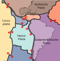
The Nazca plate is subducted under the South American plate .
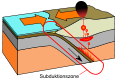
Schematic representation of the subduction of an oceanic plate under a continental plate.

Spread of the tsunami after the Valdivia earthquake in 1960.

Overview map of historical earthquakes in Chile with information about the magnitude, as well as the earthquake from September 2015.


list
Legend:
- Victims: death toll from the earthquake and its consequences (tsunami etc.)
- I: Intensity on the Modified Mercalli Scale
- M: magnitude
- M W : moment magnitude
- M S : surface wave magnitude
- M L : local magnitude
- no information: type of magnitude unknown
- T: depth of focus in kilometers
- (Q :) Source of the information
Individual evidence
- ^ Johannes Brüggen : Sobre el terremoto de Angol. Traiguén del 19 de abril de 1949. Reprint of the Revista Universitaria , Vol. 34 (1949), No. 1, Santiago de Chile 1949.
- ↑ US Geological Survey: Historic World Earthquakes ( English ) Archived from the original on July 28, 2010. Info: The archive link was automatically inserted and not yet checked. Please check the original and archive link according to the instructions and then remove this notice. Retrieved June 10, 2011.
- ↑ http://earthquake.usgs.gov/earthquakes/eventpage/usc000nzvd#general USGS: M8.2 - 94km NW of Iquique, Chile
- ↑ http://www.onemi.cl/noticia/autoridades-entregaron-balance-de-afectacion-por-sismo-de-mayor-intensidad/Lt ( page no longer available , search in web archives ) Info: The link was automatic marked as defective. Please check the link according to the instructions and then remove this notice. . ONEMI.cl (Oficina Nacional de Emergencia del Ministerio del Interior y Seguridad Pública de Chile) September 18, 2015, accessed September 18, 2015.
- ↑ http://orf.at/#/stories/2300059/ Thousands after earthquake in Chile without shelter, orf.at, September 21, 2015, accessed September 21, 2015.
- ↑ http://www.eskp.de/schweres-erdbeben-in-chile/ ESKP: Earth System Knowledge Basis, accessed September 17, 11 a.m. UTC.
- ↑ http://orf.at/stories/2299315/2299316/ Mass evacuation after earthquake in Chile: tremors had a magnitude of 8.3, orf.at, September 17, 2015.
- ↑ Tsunami warning after the earthquake in Chile orf.at, December 25, 2016, accessed December 25, 2016.
See also
Web links
- NGDC database: Significant earthquakes in Chile