
Physical geography of Chile

Chile is a country that stretches for 4,300 kilometers in a north-south direction along the Andes and Pacific Oceans , but is only 180 kilometers wide on average. Due to the long north-south extension over more than 39 degrees of latitude, but also the considerable height differences in west-east direction, Chile has a great variety of climatic and vegetation zones.
Relief and geology

The Chilean relief can be roughly divided geotectonically into three areas: the Andes in the east, the transition area ( Pampa de Tamarugal and Valle Longitudinal ) in the middle and the coastal mountains ( Cordillera de la Costa ) in the west.
To the
The Chilean Andes can be divided into four larger blocks in terms of their geological-tectonic structure from north to south, whereby all areas have in common that they only fall below the 2000 m line in a few places in the south of the country.
In the north, the Chilean Andes consist of a string of pearls , more than 1000 km long, of recent stratovolcanoes , which reach the highest mountain in the country, the Ojos del Salado (6,880 m), south of the 27th parallel. This is a highly explosive, rather basic volcanism that extends over extensive ignimbrite areas.
The first block is joined between the 27th and 33rd parallel, which roughly corresponds to the height of Santiago, the high cordillera, the peaks of which are up to 5000 m high. On the Argentine side, the Andes reach their highest elevation here between 32 ° S and 33 ° S with the Aconcagua . The overburden in this area consists of Mesozoic-Cenozoic sediments and volcanic rocks, which are repeatedly broken through by granitic intrusions. At the height of Vallenar (29 ° S) even the old basement of gneiss and mica schists emerges. This block is free of young volcanism.
South of the 33 ° S, another elongated volcanic chain sets in with the 6800 m high Tupungato volcano. It is composed of a large number of highly explosive stratovolcanoes, which in turn consist of andesitic to basaltic lavas. This 1000 km long chain of volcanoes quickly loses height in the south and extends roughly to 42 ° S south of Puerto Montt .
From 42 ° S, there are Mesozoic and Tertiary sedimentary overburden that lie on top of the metamorphic basement. In this zone there are only a few isolated volcanoes and the altitude of 3000 m is rarely exceeded. The Pleistocene glaciation with numerous glacial lakes, karen and fjords is characteristic of the relief.
Transition area
The transition area between the coastal cordillera and the Andes can be divided into two areas: the Pampa de Tamarugal in the north and the longitudinal valley in the central-southern area. Both are distinct trench systems. The Pampa de Tamarugal extends on average at an altitude of 1000 m above sea level. M. between the Peruvian border (17 ° S) and approximately the height of Copiapó (27 ° S).
The Longitudinal Valley or Central Valley begins roughly at the height of Santiago (32 ° S) and dips into the sea at Puerto Montt (41 ° 30 'S), where it extends submarine over the island of Chiloé to the Taitao peninsula (43 ° S) continues. However, its tectonic structure already stands out in the canals from 47 ° S. The southern section between Temuco and Puerto Montt is characterized by a diverse range of glacial shapes.
Coastal mountains
The coastal cordillera extends south of the island of Chiloé over the entire western part of the country with a short interruption. In the north of the country between Arica and Chañaral (26 ° S) they suddenly rise up as a steep coast to over 2000 m in places. Since the few rivers in this area do not have the strength to break through due to the extremely arid climate, it is only cut by a few valleys here. The valley systems only accumulate south of Chañaral. The coastal mountains flatten towards the south and finally only reach heights of over 1000 m in a few places in the Little South. The coastal cordillera continues from 44 ° S (Chonos Archipelago) as an island chain.
Volcanism and earthquakes


Almost in its entire north-south extent Chile is strongly characterized by volcanism. Some of the most significant volcanoes in the country are
- Nevado Ojos del Salado , 6880 m, III. Region ( Región de Atacama )
- Tupungato , 6800 m, Capital Region ( Región Metropolitana )
- Volcán Llullaillaco , 6739 m, II. Region ( Región de Antofagasta )
- Volcán Parinacota , 6342 m, XV. Region ( Región de Arica y Parinacota )
- Volcán Licancábur , 5916 m, II. Region ( Región de Antofagasta )
- Descabezado Grande , 3830 m, VII. Region ( Región del Maule )
- Volcán Villarrica , 2840 m, Region VIII ( Región de la Araucanía )
- Volcán Osorno , 2652 m, X. Region ( Región de los Lagos )
- Volcán Cerro Hudson , 1905 m, XI. Region ( Región de Aisén )
The world's strongest earthquake recorded so far was the Valdivia earthquake in 1960 with a magnitude of 9.5 Mw on the moment magnitude scale . On February 27, 2010 , the earth shook with a force of 8.8 MW north of Concepcion.
→ See also: List of earthquakes in Chile , List of volcanoes in Chile
climate
Climatic conditions
Several factors play an important role in the climatic character of Chile.
One of the most important influencing factors is the cold Humboldt Current , which flows northward on the coast of Chile and Peru and brings cool deep water to the surface. Due to the cold surface water, the nearby layers of air cool down, which creates an inversion weather situation and thus a stable stratification of the atmosphere . This inversion weather situation leads to the fact that no air parcel rises and condenses due to warming, and so precipitation occurs. A stationary high pressure area develops , which is predominant in the southern summer and southern winter. The air layers close to the ground often reach their level of condensation, so that fog often forms on the coasts.
This stable high pressure formation leads to so-called coastal deserts . Since the high pressure area is so stable that there is no precipitation for several decades, deserts form on the coasts. Therefore the north of Chile is characterized by desert regions. The Atacama Desert is one of the driest areas on earth, where it has not rained in places for centuries.
The second major influencing factor is the high mountains of the Andes . Southern Chile is in the area of influence of cyclonic cold fronts , which form due to the pressure gradient from the high pressure off the coast of Chile to the polar low pressure regions. These fronts accumulate on the windward side in the west of the Andes, and advective accumulation of precipitation occurs. Patagonia is most frequently affected, as hypermaritime, i.e. very humid, air masses accumulate and rain on the Andes all year round. In the Patagonian Andeanlee, there is therefore a drought and the foehn can set in. Foehn means that the rainy, dry and warm air masses lower on the leeward side and there is a warm, dry wind. Due to the shift of the fronts to the north in the southern winter (since the intra-tropical convergence zone moves north with the zenith of the sun), the central zone and the south of Chile are characterized by winter precipitation. Here one can distinguish between episodic precipitation in central Chile and periodic precipitation in the Lesser South of Chile. The southern summer months in the Little South of Chile are subtropically warm and dry.
Climatic classification
The Great North of Chile (17 ° - 28 ° S), called desert Chile , is characterized by permanent stable high pressure weather conditions, lack of precipitation and extensive deserts or high mountain semi-deserts.
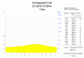
The Little North and the Central Zone (28 ° - 38 ° S), known as the river oasis , are subtropically warm and dry, with episodic winter precipitation occurring. They are growing area for wine and fruit with artificial irrigation.
The Little South of Chile (38 ° - 42 ° S), called forest clearing or Chilean Switzerland , is characterized by periodic winter precipitation and high air temperatures. There are evergreen forests and meadows.
The Great South of Chile (42 ° - 55 ° S), called the jungle Chile , has high rainfall all year round. There is a temperate rainforest.
Climate diagram Antofagasta ( Great North )
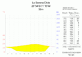
Climate diagram La Serena ( Little North )
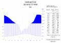
Climate diagram Valdivia ( Little South )

Climate diagram Punta Arenas ( Great South )


Glacial phenomena
In central and southern Chile, the highest mountains are glaciated, as there is periodic rainfall and correspondingly low temperatures at altitude. In Patagonia, glaciers are very common due to the extreme rainfall and sometimes cold temperatures and even calve into the sea in some places. Furthermore, there are remains of the Quaternary glaciation in the Patagonian Andes , which hold up as a 20,000 km² Patagonian ice sheet .
El Niño

Another important climate phenomenon for Chile is the El Niño phenomenon . This is actually not, as is often wrongly used, a climatic, but a purely oceanic phenomenon. The cold water flows off South America stop and warm water gathers off the South American coast. As a climatic consequence, the normally prevailing stable high pressure situation is canceled out and there is a reversal of the Walker circulation (between South America and Indonesia, parallel to the longitude). This reversal has serious consequences, as the warm water off the coast leads to a drastic death of the sea creatures used to cold water and heavy precipitation occurs on land. The landscape, which is otherwise characterized by drought, can be severely damaged by mudslides and landslides during such heavy precipitation events.