Erigabo
| Ceerigaabo Erigabo |
||
|---|---|---|
|
|
||
| Coordinates | 10 ° 37 ' N , 47 ° 22' E | |
| Basic data | ||
| Country | Somalia | |
| also claimed by Somaliland Puntland Khaatumo
|
||
| Sanaag | ||
| ISO 3166-2 | SUN-SAT | |
| District | Erigabo | |
| height | 1782 m | |
| Residents | 27,700 (calculated in 2013) | |
| politics | ||
| mayor | Ismail Haji Nuur | |
| Political party | Wadani (Somaliland National Party) |
|
|
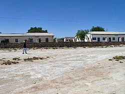
Streets in Erigabo
|
||
Erigabo (also written Erigavo , Somali : Ceerigaabo ) is a city in northern Somalia with around 27,700 inhabitants according to current calculations. However, estimates are significantly higher at up to 180,000. The inhabitants are mainly for communities of Wars Angeli from the clan family of Harti- Darod .
Erigabo is the capital of the Sanaag region , which is controversial between Somaliland and Puntland , with the short-lived Maakhir between 2007 and 2009 and from 2012 also Khaatumo .
geography
The city is located in the Al Mado Mountains, around 1800 m above sea level, at the foot of Somalia's highest mountains north of the city. The largest mountain in Somalia, the Shimbiris with 2460 m height and the only slightly smaller Surud Cad , Waraq , Jilin and Da'aro , all over 2000 m.
About 10 km north of the city there are cypress forests, mainly made of juniper. However, large parts of the region's former tree population have now disappeared due to heavy logging of the increased population.
history
Historical graves made of stones piled up to three meters high in the area up to the coast, the so-called Galla graves (Talla Galla), indicate very ancient settlements in the region.
Under British colonial administration, the place was known as El Dur Elan . In 1920 the Royal Air Force stationed eight aircraft there, which were used for bombing in the last campaign against the dervishes of Mohammed Abdullah Hassan (1856-1920). A simple brick memorial in the city center with the destroyed engine block of a British double-decker aircraft is a reminder to this day.
Infrastructure and administration
The city is the seat of several international and local NGOs . Various Somaliland authorities have also established themselves in Shaab , the city's government district. Erigabo has a hospital and an airfield east of the city.
The road connections to and from Erigabo are even worse than usual in Somalia due to the mountainous location. To the east one reaches Hadaaftimo and Badhan , to the north, to the coast of the Gulf of Aden , a road leads to the town of Maydh, about 60 km away, and to Xiis .
The regional telephone company Golis Telecom has equipped Erigabo with a relatively modern cellular network. Another telephone operator, STC Somaliland, restricts itself to fixed line services and supplies electricity via its lines.
Web links
Individual evidence
- ↑ Yusuf M Hasan: Somaliland: Las Anod Gets Elected Mayor. (No longer available online.) In: Somaliland Sun. December 20, 2012, archived from the original on August 20, 2013 ; accessed on July 16, 2013 . Info: The archive link was inserted automatically and has not yet been checked. Please check the original and archive link according to the instructions and then remove this notice.
- ↑ bevölkerungsstatistik.de
- ↑ Africa Ultra-prominences. 84 Mountains with prominence of 1,500 m (4,921 ft.) Or greater. In: peaklist.org. Retrieved November 3, 2012 .
- ↑ Tallest mountains in Somalia. In: rastlos.com. Retrieved November 3, 2012 .
- ↑ Chris Magin, Christine Burdette: Somali montane xeric woodlands. In: worldwildlife.org. Retrieved November 3, 2012 .
- ↑ Herbert, Erwin; Risings and Rebellions 1919-1939; Nottingham 2007; ISBN 1-901543-12-9 .

