It Pantaleu
| It Pantaleu | ||
|---|---|---|
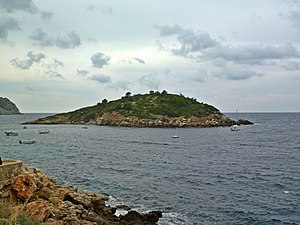
| Es Pantaleu in front of Sant Elm | ||
| Waters | Mediterranean Sea | |
| Archipelago | Balearic Islands | |
| Geographical location | 39 ° 34 '37 " N , 2 ° 20' 52" E | |
|
|
||
| length | 220 m | |
| width | 180 m | |
| surface | 2.4 ha | |
| Highest elevation | 26 m | |
| Residents | uninhabited | |
Es Pantaleu (Catalan) or El Pantaleu (Spanish) is an uninhabited island off the coast of Mallorca . It is located near the west end of the island in the bay of Sant Elm . The base of the island is 2.4 hectares, the highest point rises 26 meters above sea level .
history
The island gained historical importance in 1229, when James I of Aragón anchored his ships off the island while crossing to Mallorca in September of this year to seek protection from a storm. From here, the coast of Mallorca was explored and the beach near today's Santa Ponça was chosen as the ideal landing site for the Christian armed forces to begin the Reconquista of the Balearic Islands . The bay of Sant Elm had proven to be too well defended.
Today the island, about 300 m from Sant Elm Beach, is a popular destination for safe swimmers. It has been part of the Sa Dragonera Nature Park since 1995 and, apart from the tiny pebble beach, cannot be entered.


