
Etna (river)
| Etna | ||
 The Etna River |
||
| Data | ||
| Water code | NO : 012.EZ | |
| location | Innlandet (Norway) | |
| River system | Drammenvassdraget | |
| Drain over | Randsfjord → Randselva → Storelva → Tyrifjord → Drorgenselva → Drsamefjord → Skagerrak | |
| muzzle | at Dokka in the lake Randsfjord Coordinates: 60 ° 47 ′ 55 ″ N , 10 ° 8 ′ 30 ″ E 60 ° 47 ′ 55 ″ N , 10 ° 8 ′ 30 ″ E |
|
| Mouth height |
134 m
|
|
| Catchment area | 2085 km² | |
| Outflow at the level at the mouth |
MQ |
36.7 m³ / s |
| Left tributaries | Dokka | |
| Communities | Dokka | |
The Etna is a river in Norway , which rises in the raised bogs between Skaget and Marsteinhøgda (municipality Øystre Slidre in the province ( Fylke ) Innlandet ), mostly through the municipality Etnedal named after him , at Dokka (municipality Nordre Land ) with the Dokka flows together to flow into the Randsfjord as Dokka-Etna .
Attractions
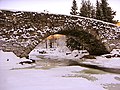
There are two bridges along the river that deserve special attention: Lunde bru and Høljeraast bru . Lunde bru is Northern Europe's longest stone arch bridge; There are war memorials from World War II near Høljerast bru.
Three kilometers south of the Møllerstufossen (waterfall) are famous rock carvings on Møllerstufossen from the younger Stone Age (Norwegian: helleristninger).
Tributaries
After the Etna has flowed through the Etnsenn and Kalvefjord, other, mostly smaller streams are added:
Tributaries and hydraulic structures
|
||||||||||||||||||||||||||||||||||||||||||||||||||||||||||||||||||
Individual evidence
- ↑ a b NVE ( page no longer available , search in web archives ) Info: The link was automatically marked as defective. Please check the link according to the instructions and then remove this notice. (norway .; PDF; 624 kB)
Web links
- Official website of Etnedal Municipality (Norwegian)
See also
More pictures
- Etna

Rock art
Lunde bru

Lunde bru


