Exhibition Place
The Exhibition Place is a multifunctional usable venue in Toronto . The square to the west of the city center is named after the Canadian National Exhibition , which takes place from mid-August for 18 days. The area for trade fairs, sports and music events is almost 79 hectares. Among other things, there is the BMO Field football stadium and a street circuit on Exhibition Place. Its total area is 104 hectares.
history
French traders set up under the order of Jacques-Pierre de Taffanel de la Jonquière 1750/51 on the site of today's Exhibition Place Fort Rouillé as a trading post. The area was already an important trade route for the Native American . Hence the aim of the French was to obtain their trade goods before they reached the British trading posts. Already in 1759 the fort fell victim to a fire during fighting.
Two American invasions of York , one on April 27, 1813 during the British-American War and another on July 31 of the same year, took place over the area.
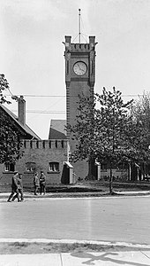
In the 19th century there were efforts to relocate the old Fort York to the area of today's Exhibition Place. In the years 1840–41 a number of buildings were built for it; However, no defenses were built. The British gave the facility to Canada in 1870, which it renamed Stanley Barracks in 1893 . Until 1947 it was used as a garrison town and in 1950 it was demolished except for the headquarters. This building was used as a naval museum until 1997.
In 1878 the first provincial agricultural fair was held on Exhibition Place. The venue traditionally changed annually, and when Ottawa was selected as the location in 1879 , the city of Toronto decided to hold its own fair. Originally called the Toronto Industrial Exhibition and has been held annually since 1904, it was later renamed the Canadian National Exhibition .
An annual Champ Car motor sport event took place on the exhibition grounds from 1986 to 2007 . Since 2009 the race has been called Honda Indy Toronto and belongs to the IndyCar Series . The 2.824-kilometer street circuit with eleven corners is driven in 85 laps.
description
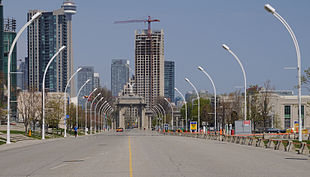
The area, which almost borders the shores of Lake Ontario , is bounded to the east by Princes' Gates. The gate is named after Prince Edward VIII of Wales , who visited Exhibition Place with his brother Prince George in 1927 . Lake Shore Park and Coronation Park are also on the eastern edge of the area. To the south, the exhibition grounds are bordered by Lake Ontario and the Ontario Place amusement and amusement park , which is located on offshore islands in the lake. The Gardiner Expressway runs north of Exhibition Place and Lake Shore Boulevard south.
The site is connected to the local public transport system. It has its own station on the Lakeshore West Line of GO Transit (Toronto - Hamilton ). The fair is the terminus of lines 509 Harbourfront and 511 Bathurst on the Toronto tram . In addition, two special bus lines drive to the site.
building
There are a number of exhibition halls on Exhibition Place, as well as historical buildings and monuments. The largest hall, the Direct Energy Center in the east, is also Canada's largest exhibition hall. It is divided into ten individual halls and offers around 90,000 square meters of exhibition space.
From 1879 to 1999 the Exhibition Stadium , which was the home of the Toronto Blue Jays and Toronto Argonauts, was on the site .
The Automotive Building , built in 1929, is located near Princes Gate. The concert shell dates from 1936. Many famous musicians gave concerts there such as B. Guy Lombardo , Louis Armstrong or Joni Mitchell . The Better Living Center is a classic modern exhibition building opened in 1964.
The Horticulture Building dates from 1907. This is a trade fair building that imitates the architectural style of the Middle Ages. There is a white dome at the level of the main entrance.
The Fort Rouillé Monument , an obelisk reminiscent of the former Fort Rouillé, stands on the site . The Shrine Peace Memorial from 1930 shows an angel figure holding up a crown of leaves made of olive branches. The figure rests on a globe held by a female sphinx . The monument was designed by Charles Keck (1875–1951).
In the northwest of the plant is a 91 meter high wind turbine ( Toronto Windmill ). It was erected on December 18, 2002.
Web links
Coordinates: 43 ° 37 ′ 58 " N , 79 ° 24 ′ 58" W.


