Exploits River
| Exploits River | ||
|
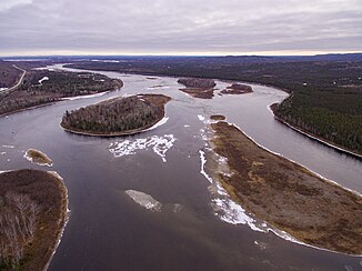
Exploits River west of Grand Falls-Windsor |
||
| Data | ||
| location | Newfoundland Island , Newfoundland and Labrador ( Canada )
|
|
| River system | Exploits River | |
| origin |
Red Indian Lake 48 ° 45 ′ 46 " N , 56 ° 35 ′ 54" W. |
|
| Source height | 167 m | |
| muzzle |
Bay of Exploits , Atlantic Ocean Coordinates: 49 ° 4 ′ 52 " N , 55 ° 19 ′ 39" W 49 ° 4 ′ 52 " N , 55 ° 19 ′ 39" W |
|
| Mouth height | 0 m | |
| Height difference | 167 m | |
| Bottom slope | 1.5 ‰ | |
| length | 115 km (including Lloyds River 322 km) | |
| Catchment area | 10,241 km² | |
| Discharge at the gauge below Stony Brook A Eo : 8640 km² Location: 31 km above the mouth |
MQ 1969/1995 Mq 1969/1995 |
272 m³ / s 31.5 l / (s km²) |
| Left tributaries | Badger Brook, Junction Brook | |
| Right tributaries | Noel Paul's Brook , Sandy Brook , Stony Brook , Great Rattling Brook , Little Rattling Brook , Jumpers Brook | |
| Small towns | Grand Falls-Windsor | |
| Communities | Badger , Bishop's Falls | |
|
Location of the river in Newfoundland |
||
The Exploits River is a river that flows through the central part of the island of Newfoundland off the Atlantic coast of Canada .
River course
It has a length of 115 km and drains an area of 10,241 km². It forms the drain of the regulated Red Indian Lake . With the source river Lloyds River it is the longest river on Newfoundland with 322 km. It flows into the Bay of Exploits near Botwood .
At Grand Falls-Windsor and Bishop's Falls there are provincial owned and operated hydroelectric plants operated by Newfoundland and Labrador Hydro , a subsidiary of Nalcor Energy . Forestry and mining are important industries in this area .
The Beothuk people lived on the banks of the river and had winter camps near Red Indian Lake. It spent the summer fishing in the Bay of Exploits, using the river as a travel route.
Hydrology
The Exploits River at Grand Falls, 31 km above the mouth, has an average discharge of 272 m³ / s. The highest monthly discharges usually occur in May with an average of 470 m³ / s. In 2003, a flood of the Exploits River forced the evacuation of Badger .
Wildlife
The river serves as a spawning area for Atlantic salmon and other fish. The stock of salmon increased significantly after the installation of fish ladders , as this made sections of the river that were previously inaccessible for the fish. In the river system of the Exploits River probably following other types of fish: speckled trout , lake trout , three-spined and nine-spined stickleback , Arctic Norway , American eel and the sea lamprey . Other typical aquatic inhabitants are the Canadian beaver , muskrat and North American otter, as well as Lithobates clamitans , a species of frog introduced on the island of Newfoundland. Forest caribou , elk and black bears live in the river valley .
Web links
- Exploits River at Natural Resources Canada
Individual evidence
- ↑ a b Exploits Generation . Nalcor Energy. Retrieved October 9, 2018.
- ↑ a b c Government of Canada: Historical Hydrometric Data Search Results: Station 02YO005
- ↑ a b Water Quality Station Profile, Station #: NF02YO0020, EXPLOITS RIVER AT ASPEN BROOK . Environment and Conservation, Government of Newfoundland and Labrador - Canada. Retrieved December 11, 2018.

