
Fürstein
| Fürstein | ||
|---|---|---|
 Steep west flank of Wasserfallenegg |
||
| height | 2040 m above sea level M. | |
| location | Canton border Lucerne / Obwalden , Switzerland | |
| Mountains | Emmental Alps | |
| Dominance | 9.2 km → Hächle | |
| Notch height | 456 m ↓ Saddle Pass | |
| Coordinates | 648 091 / 194 051 | |
|
||

The Fürstein is a mountain in the Emmental Alps on the border of the Swiss cantons of Lucerne and Obwalden . At 2040 m above sea level M. Höhe, it is the highest summit in the Belief Mountain Pass region and a popular hiking and ski tour destination. Alternatively, it can also be reached from Flühli .
The two secondary peaks Fürstein Südgipfel ( 1994 m ) and Chli Fürstein ( 1900 m ) connect to the south of a 1950 m high saddle. The west and north sides of the Grasberg drop steeply and rocky around 200 meters, the east and south flanks are less steep. To the south-east lie the Sewenseeli at an altitude of 1689 m , a little above the Alp and the Ober Sewen chapel . Towards the east the ridge merges into the Wissguber ( 1941 m ).
photos

East side of Sewen with the south summit on the left
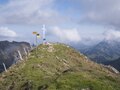
Summit with a cross
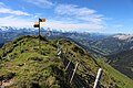
View from the cross to the south to the Bernese Alps


Web links
- Fürstein on hikr.org