Fajã de Água
| Fajã de Água | ||
|---|---|---|
|
|
||
| Coordinates | 14 ° 52 ′ N , 24 ° 45 ′ W | |
| Basic data | ||
| Country | Cape Verde | |
|
Archipelago |
Ilhas de Sotavento | |
| District | Brava | |
| ISO 3166-2 | CV-BR | |
| height | 423 m | |
| Residents | 126 (2010) | |
|
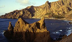
Bay with town in the background
|
||
Fajã de Água is a valley and town in the west of the island of Brava , the westernmost of the Ilhas de Sotavento (Eng., Islands under the wind ') on Cape Verde . In Cape Verdean Creole the place is called Fajan di Água . At the 2010 census it had 126 inhabitants.
Surname
The proper name is made up of pt. , Fajã 'and' de água '(the water). The word 'fajã', which occurs only in Portuguese, denotes supratidal , flat heaps of rubble by the sea with a hummock-like surface, which originate from landslides or lava flows and which are often found on the rocky cliffs of the volcanic Azores and Cape Verde.
geography
The village is located in a valley that begins at over 400 meters on a plateau with numerous farms and is the most fertile on Brava. Coconut palms , sugar cane and bananas grow here , and vegetables are grown on irrigated terraces with typical stone walls. The valley ends by the sea in a sheltered bay, the Bay of Fajã.
history
In the 18th and 19th centuries, whaling was one of the main sources of income for the people of Brava. It was not uncommon for whaling ships from New England to dock in Fajã de Agua to fetch provisions and recruit crews. Quite a few residents of the village emigrated on this occasion. Fajã de Água was the island's main port until 1843, when the current port of Furna was established.
Transport and infrastructure
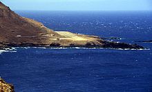
A small airfield with an asphalt runway was laid out in 1989 and opened in 1992. A new road was laid from the village, which leads through a rock cut and ends at the airfield. The road and airfield were built by the local, mostly unemployed, population, financed by the Society for Technical Cooperation in the Food-for-Work program . Air connections to the neighboring island of Fogo and the main island of Santiago have been set up. After a short time, however, the airport had to be closed again, as the frequent strong winds prevented take-offs or landings on most days.
Fajã de Água is connected by a good road via Cova Rodela to the island's capital, Vila Nova Sintra , around eight kilometers away , and can be reached several times a day by Aluguer buses, but there are no fixed timetables. These buses, which are typical of Cape Verde, run on a set route, but only leave when enough passengers have arrived.
A hiking trail leads uphill from the village to the pilgrimage site of Nossa Senhora do Monte, about three kilometers away, in the middle of the island.
On the street that comes down from Vila Nova Sintra and runs along the beach there is a row of houses with a motel, restaurant, church and shops. There is a school on the southern edge of the village.
Bathing possibilities
The seas around Brava are rough and the coast is rocky and steep almost everywhere. About a kilometer from the village, stairs lead from the road to the airport to a natural swimming pool. If the wind is not too strong and the waves are not too high, you can swim here. Further south is the dark sandy beach of Porto do Portete , which can only be reached on foot.
Attractions
Across from the small church on the northern edge of the village, a basalt monument ( Monumento aos Emigrantes ) was erected on Hauptstrasse in 1993 . It is reminiscent of the sailor “Matilde”, who set sail from Fajã de Água for America on August 21, 1943. However, the ship was lost on the Atlantic, 51 people were killed. Almost every family in Fajã de Água lost one or more relatives.
literature
- Susanne Lipps, Oliver Breda: Travel Atlas Cape Verde Islands . Dumont, Ostfildern 2005, ISBN 3-7701-5968-3 , Insel Brava, p. 153-156 .
Individual evidence
- ↑ INE - CENSO 2010. ( Memento of the original from April 9, 2014 in the Internet Archive ) Info: The archive link was inserted automatically and has not yet been checked. Please check the original and archive link according to the instructions and then remove this notice. In: Portal do Instituto Nacional de Estatística (website), Brava ( Memento of the original from September 5, 2014 in the Internet Archive ) Info: The archive link was inserted automatically and has not yet been checked. Please check the original and archive link according to the instructions and then remove this notice. (XLS document).
- ↑ G. Lameiras, J. Fontiela, P. Borges, H. Calado, O. Vieira, B. Rangel, A. Gallagher: Coastal Hazards of Fajã do Calhau (São Miguel - Azores). A first approach. In: Journal of Coastal Research. ISSN 0749-0208 , special issue 56, 2009, pp. 827-831 ( PDF ), here p. 827.
- ↑ a b Susanne Lipps: Cape Verde Islands. Dumont, Ostfildern 2009, p. 275.
- ^ Susanne Lipps: Cape Verde Islands. Dumont, Ostfildern 2009, p. 276.
- ↑ Pitt Reitmaier, Lucete Fortes: Cabo Verde. Bielefeld 2009, p. 420.


