Fayette (Missouri)
| Fayette | |
|---|---|
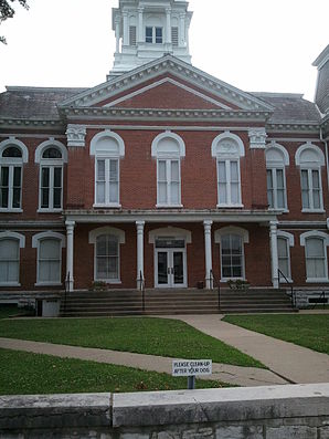
 Town Square in Fayette |
|
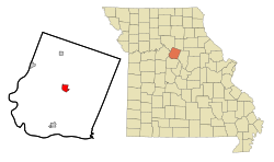
| Location Fayettes in county and state | |
| Basic data | |
| Foundation : | 1823 |
| State : | United States |
| State : | Missouri |
| County : | Howard County |
| Coordinates : | 39 ° 9 ′ N , 92 ° 41 ′ W |
| Time zone : | Central ( UTC − 6 / −5 ) |
| Residents : | 2,688 (as of 2012) |
| Population density : | 467.5 inhabitants per km 2 |
| Area : | 5.85 km 2 (approx. 2 mi 2 ) of which 5.75 km 2 (approx. 2 mi 2 ) is land |
| Height : | 213 m |
| Postal code : | 65248 |
| Area code : | +1 660 |
| FIPS : | 29-23842 |
| GNIS ID : | 0717869 |
| Website : | fayette.missouri.org |
| Mayor : | Kenneth O'Brian |
Fayette is a city in Howard County , Missouri in the United States . At the time of the 2010 United States Census , Fayette had a population of 2,688. The city is the county seat of Howard County and is part of the Columbia, Missouri Metropolitan Statistical Area .
history
Fayette was designated a county seat in 1823 . It got its name after Marie-Joseph Motier, Marquis de La Fayette , who worked on the side of the colonists in the Revolutionary War and was on a visit to the United States in 1824, during which he toured 24 states.
geography
Fayettes geographical coordinates are 39 ° 9 ' N , 92 ° 41' W . According to the United States Census Bureau , the city has an area of 5.85 km 2 , of which 5.75 km 2 is land and 0.10 km 2 is water. Fayette is drained by the Adams Fork to the west and the Bonne Femme Creek to the east of the urban area; both watercourses merge south of the city and the Bonne Femme Creek then strives south to the Missouri River .
Missouri Route 5 and Missouri Route 240 run north into Fayette; MO-5 leads south of the city limits to the southwest and MO-240 turns in a southeast direction. An abandoned route of the Missouri-Kansas-Texas Railroad runs through Fayette.
Demographics
2010 census
At the United States Census 2010 , Fayette had 2,688 residents. The population density was 467.5 inhabitants per square kilometer. There were a total of 1,097 residential units, that is 190.8 per square kilometer. Of the population, 83.5% were White, 13.0% African American, 0.3% Natives, 0.5% Asians, and 0.1% Pacific Islanders. 2.1% stated that they belong to two or more races and 0.6 stated that they belong to other races. 2.2% of the population identified themselves as Hispanics or Latinos.
Of the 949 households, 2.2 were families. Minors lived in 509% of households and married couples in 25.7% of households. 36.9% of households were headed by women without husbands, and men without wives headed 12.6% of households. 4.1% of households were made up of non-families and 46.4% of households were made up of individuals and 37.0% of households were made up of individuals who were over 65 years of age at the time of the survey. The average household size was 17.5 people, families had an average of 2.17 members.
The median age was 2.85 years. 26.1% of the population were minors, 16.7% were in the 18–24 age group; 32.0% were 25–44 years old, 15.9% were 45–64 years old, and 19.5% were 65 years old or older. 15.8% of the population were male and 48.7% female.
2000 census
At the time of the United States Census 2000, Fayette lived in 2793 people. The population density was 483.6 people per km ². There were 1133 housing units at an average of 196.2 per km ². The Fayette population was 79.16% White , 18.33% Black or African American , 0.47% Native American , 0.21% Asian , 0.04% Pacific Islander , 0.47% said other races belong to and 1.32% named two or more races. 0.93% of the population declared to be Hispanic or Latinos of any race.
The residents of Fayette distributed to 976 households out of which 25.0% were living in children under 18 years. 41.4% of households were married, 14.5% had a female head of the household without a husband and 40.7% were not families. 34.5% of households were made up of individuals and someone lived in 16.5% of all households aged 65 years or older. The average household size was 2.18 and the average family size was 2.79 people.
The population was split into 17.9% minors, 28.2% 18–24 year olds, 19.5% 25–44 year olds, 16.2% 45–64 year olds and 18.1% aged 65 and over or more. The median age was 29 years. For every 100 women there were 91.0 men. For every 100 women over the age of 18, there were 89.3 men.
The median household income in Fayette was 27,276 US dollars and the median family income reached the amount of 35,694 US dollars. The median income for men was $ 27,768, compared with $ 20,833 for women. The per capita income was $ 13,451. 15.6% of the population and 9.1% of families had an income below the poverty line , including 18.1% of minors and 20.0% of those aged 65 and over.
education
Fayette is home to Central Methodist University , a private, four-year university. Fayette has an elementary school (L. J. Daly), a middle school (W. N. Clark), and a high school (Fayette).
sons and daughters of the town
- John Bullock Clark junior (1831–1903), politician, Confederate General in the American Civil War
- Joseph C. Hendrix (1853-1904), politician
- John F. Shafroth (1854-1922), politician
- Henry Smith Pritchett (1857–1939), educator and astronomer
- Samuel C. Major (1869–1931), politician
supporting documents
- ↑ Population Estimates ( English ) United States Census Bureau . Retrieved January 1, 2015.
- ↑ Find a County ( English ) National Association of Counties. Retrieved January 1, 2015.
- ↑ David Wolfe Eaton: How Missouri Counties, Towns and Streams Were Named . The State Historical Society of Missouri, 1916, p. 174.
- ↑ American FactFinder ( English ) United States Census Bureau. Retrieved April 11, 2013.
Web links
- Historical maps by Fayette in the Sanborn Maps of Missouri Collection @ University of Missouri
