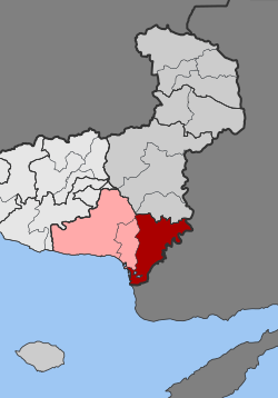
Feres
|
Feres municipal district Δημοτική Ενότητα Φερών (Φέρες) |
||
|---|---|---|
|
|
||
| Basic data | ||
| State : |
|
|
| Region : |
East Macedonia and Thrace
|
|
| Regional District : | Evros | |
| Municipality : | Alexandroupoli | |
| Geographic coordinates : | 40 ° 54 ' N , 26 ° 10' E | |
| Height above d. M .: | 43 m (average) |
|
| Area : | 411.160 km² | |
| Residents : | 8,551 (2011) | |
| Population density : | 20.8 inhabitants / km² | |
| Code No .: | 030103 | |
| Structure: |
2 city districts 5 local communities |
|
| Located in the municipality of Alexandroupoli and in the Evros regional unit | ||
Feres ( Greek Φέρες ( f. Pl. ), Older also Fere Φέραι, formerly Vira Βήρα, Bulgarian Фере Fere , Turkish Fareçik, Fereçik) is a small Greek town with around 5000 inhabitants. Until 2010, Feres and the surrounding villages formed the independent municipality of Feres in the prefecture of Evros , but became part of the municipality of Alexandroupoli in 2011 and has been a municipality of the same ever since.
geography
Feres is located in the northeast of Greece in Thrace , directly on the state border with Turkey . The place is located on the European route from Keşan to Alexandroupoli . The area is shaped by the delta of the Evros River .
history
During the First Balkan War , the region and the city were conquered by Bulgarian troops. When the Second Balkan War broke out, Bulgarian troops withdrew from Western Thrace in July 1913 and Greek troops captured Dedeagach and Feres.
A little later, however, Greece ceded the region and the two cities, which were meanwhile overcrowded with Bulgarian refugees from Western Thrace and Asia Minor (see Thracian Bulgarians ), to the Provisional Government of Western Thrace , with the aim of terminating the negotiations that were ongoing in Constantinople at the same time To influence the Ottoman Empire and Bulgaria in such a way that there is no peace between the two countries.
Feres was largely destroyed in the "Battle of Feres" in 1913. In it, a few dozen (approx. 20 ??) poorly armed Bulgarian Komitaji fought under the leadership of Dimitar Madscharow against Turkish militants ( Başı Bozuk ) who were supported by the special organization Teşkilât-ı Mahsusa and who exploited the armed conflicts in Bulgaria to restore Western Thrace Bulgaria to snatch. In the days and months that followed, the large population of the Bulgarians living here was expelled, with many Bulgarians perishing (see Thracian Bulgarians ).
After the Peace of Bucharest in August 1913, Western Thrace became Bulgarian again; Bulgarian control over the region could only be restored at the end of October, beginning of November 1913, with the break-up of the Provisional Government of Western Thrace and the expulsion of the rioters' associations to Turkey.
After the First World War, Feres was assigned to Greece, but the city came under Bulgarian control again during the Second World War. Feres has been Greek since 1945.
Due to the administrative reform according to the Kapodistrias plan , the rural communities of Peplos, Pylea and Trifyllio were added to the original municipal area of the municipality of Feres in 1997; Together with Traianoupoli , bordering to the west , this community was added to the area of the Alexandroupolis community in 2011.
Attractions
- The Evros area and the Evros delta are very well known for eco-tourism. Birds in particular can be observed . The place Poros is a European stork village .
- In Feres there is an important Orthodox church , the Panagia Kosmosotira. It was in 1152 as part of a monastery of Isaac Comnenus , the third son of Alexios I established. In 1357 or 1371/2 it was converted into a mosque , only to be consecrated as a church in the 20th century.
- Remnants of a Turkish Haman .
- At the entrance to the village in the gorge there are the remains of an old mill that was expanded into a nature park .
literature
- Stefan Sinos: The monastery church of Kosmosoteira in Bera (Vira) (= Byzantine archive , volume 16). 3rd edition, Beck, Munich 2016, ISBN 978-3-406-69890-3 .
Web links
- Ferai church
- On the history of the monastery (PDF; 304 kB)
Individual evidence
- ↑ Results of the 2011 census, Greek Statistical Office (ΕΛ.ΣΤΑΤ) ( Memento from June 27, 2015 in the Internet Archive ) (Excel document, 2.6 MB)
- ↑ Archive link ( Memento of the original from July 1, 2008 in the Internet Archive ) Info: The archive link was inserted automatically and has not yet been checked. Please check the original and archive link according to the instructions and then remove this notice.
- ↑ Hüsein Mehmed: The Pomaks and Torbeschen in Moesien, Thrace and Macedonia . Sofia 2007


