
Evros (regional unit)
|
Evros regional unit Περιφερειακή Ενότητα Έβρου (Έβρος) |
|
|---|---|
 |
|
| Basic data | |
| State : | Greece |
| Region : | East Macedonia and Thrace |
| Area : | 4,242 km² |
| Residents : | 147,947 (2011) |
| Population density : | 34.9 inhabitants / km² |
| NUTS 3 code no. : | EL511 |
| Structure: | 4 municipalities |
The regional district Evros ( Greek Έβρος ) is the easternmost of the six regional districts of the Greek region of East Macedonia and Thrace . Until the implementation of the Kallikratis Plan , Evros was one of the - since 1997 self-governing - Greek prefectures, since 2011 its importance has been limited to the allocation of 12 seats in the regional council of Eastern Macedonia and Thrace. Evros is named after the river of the same name , which forms the border with Turkey here.
geography

Evros extends with a north-south extension of around 100 km on the eastern edge of the Greek Rhodope Mountains , which rise to just over 1,000 m on the border with the Rodopi regional district and cover the south-western part of the prefecture. 57.05% of the area is on the plains of the rivers and the coast, 27.86% are hill country, 15.09% is mountainous.
The northern and eastern borders are shaped by the plain of the Evros river, which flows into the north of the Ardas , a little further south of the Erythropotamos . The Evros forms the border between Greece and Turkey over 185 km in length (except for a small section near Edirne ) and flows into the Thracian Sea , the northern tributary of the Aegean , in a delta of around 500 km² . In the spring the Evros swells considerably and occasionally floods larger areas; more severe damage from floods last occurred in 1997 and 2005.
Evros borders the Greek prefecture of Rodopi to the west, the Bulgarian Oblast Chaskowo to the northwest and north , the Turkish province of Edirne to the east and is bordered to the south by the Thracian Sea, part of the Aegean Sea. The prefecture also includes the Aegean island of Samothraki , which covers almost 180 km² and lies around 40 km south of the coast, and whose mountain range Fengari, at 1624 m, forms the highest elevation in the region. The village of Ormenio in the municipality of Orestiada is the northernmost settlement in Greece.
climate
In Evros there is a moderate subtropical, winter-humid climate ( Mediterranean climate ). The higher-lying areas in the southwest are much more humid and colder than the coast and the plain of the Evros river, where the climate is relatively mild even in winter. The average temperature in the winter months is −1 to 7 ° C, in the summer months an average of 18 to 24 ° C is reached. The coldest areas are the mountain peaks in the west of the prefecture and the heights of Fengari on Samothrace. The annual sunshine duration decreases with increasing altitude and even more so from south to north, the same applies vice versa for the amount of precipitation , the values of which are between 20 and 30 l / m² in summer and 530 and 800 l / m² in winter. Calculated over the year, Evros has an average rainfall of between 740 l / m² (coasts and Evros Valley) and 960 l / m² (high altitudes in the west and on Samothrace).
nature
The landscape of the Evros Delta is characterized by lagoons , islets and salt marshes . 15 of the 350 species of plants here are halophytes . About 60% of the area still has salt soil, many areas have been drained or sweetened for agriculture. The delta is the habitat for 46 species of fish, the land areas are primarily used by birds as winter quarters, breeding or resting places. In addition to numerous species of tern, the breeding species include the black-headed gull , the red-winged curlew , the triel , the Kentish plover , the black- winged lapwing and the avocet . The delta is primarily used as winter quarters for ducks , geese and swans , but also for flamingos , shags and Dalmatian pelicans . Different species of birds of prey come to the coast, especially in winter . In addition, there are up to 150,000 birds that visit the delta as a resting place on their migration . Although the Evros Delta is officially designated as a nature reserve, illegal housing, grazing and bird hunting by locals pose a serious threat to nature in the area.
The area upstream is lined with reeds and gallery forests of poplars and willows , in the quiet pools next to the Evros you can find iris species and a rich aquatic flora such as white water lilies and water fennel . The trenches and canals, which were built for drainage after the Second World War and are now used to irrigate the fields with fresh water, are also habitat for some rare toad species and the fire-bellied toad ; the reptiles are represented by grass snakes and dice snakes , European swamp turtles and Caspian brook turtles .
The sparsely populated hinterland of the Evros extends to the Bulgarian border in the northwest. It rises in the southern part of the prefecture to the low mountain range and is largely forested. Coniferous forests, mainly black pine and Calabrian pine , alternate with deciduous forests made mainly of beech or low-growing oak . The forest of Dadia is strictly protected in the area of the municipalities of Soufli and Tychero, where a unique fauna has been preserved. 36 of the 38 European bird of prey species have been identified here, at least 23 of them also breed in the regional district. In addition to the total of 219 bird species, 40 representatives of reptiles and amphibians as well as 36 mammal species have been recorded, but the diversity of beetles and other insect species is also considerable.
The nature of the volcanic island of Samothrace is determined by the Fengari massif, which slopes steeply to the sea in the southeast. The coastal areas are largely shaped by cultural landscapes. At higher altitudes there are forests made of distressed and downy oak . The mountain range, which is rich in water, especially on the north side, is still home to the pure oriental plane tree .

The eponymous river

Forest near Kastanies, near the Ardas

Around 100 black vultures live in Dadia forest.
View of Samothraki

Hiking trail in the Dadia-Lefkimi-Soufli Forest National Park

Autumn gold cup under a fig tree


population
According to the 2011 census by the Greek National Statistics Office, there were 147,947 people in the Evros regional district.
The prefecture is characterized by persistent rural exodus. While the population of the capital Alexandroupoli increased by almost 40% from 1981 to 2001, the number of the total population only increased by 2.12% in the same period. Accordingly, the number of inhabitants in most of the other rural communities fell steadily.
Languages and religions


Largely Greek , Orthodox Christians make up the overwhelming majority of the population of the prefecture with 135,000 out of 144,000 inhabitants (93.75%). Evros comprises two dioceses (metropolises), Alexandroupolis and Traianoupolis as well as Didymoticho and Orestiada , whose metropolitan are canonically subordinate to the Ecumenical Patriarchate of Constantinople .
The Muslim minority was estimated at around 6,000 people (6.25%) in 1997, made up of Turks, Pomaks and Muslim Roma . This makes Evros of the three Thracian prefectures of Greece the one with the smallest Muslim population. At the same time, Evros, namely the area around the cities of Alexandroupoli and Didymoticho, is the main settlement area of the 5,000 to 18,000 Roma in Greece, some of whom are of the Christian and some of the Muslim religion, which is why there are no reliable figures about them. (Greece does not collect any data on the language or ethnic origin of its inhabitants.) Didymoticho is the seat of one of the three muftis appointed by the Greek state, some of whom are responsible for civil and professional matters. As the language of the Muslim minority, Turkish is permitted in dealings with religious authorities and in court, but its use is in no way encouraged by the Greek state.
Population Movements in the Early 20th Century
The lower Evros Valley was multi-ethnic and multi-religious in the 19th century. The largest population groups were Orthodox Greeks and Bulgarians, and Sunni Turks .
While Western Thrace belonged to Bulgaria, around 70,000 of the Greeks fled to the Kingdom of Greece and around 49,000 Turks to Ottoman territory, while the Bulgarian government specifically settled Bulgarians who were expelled from Macedonia and Eastern Thrace . The Bulgarians had to leave the area after the Treaty of Neuilly-sur-Seine (1919), and a large part of the Greek refugees returned to Western Thrace.
In 1920 the French occupation collected data on the population of Western Thrace. The result for April 1920 took into account the information provided by the respective population groups, in particular information on the returning Greeks who had fled to the Kingdom of Greece during the Bulgarian occupation:
| Population groups in Evros 1920 | |||||||
|---|---|---|---|---|---|---|---|
| district | Turks | Bulgarians | Greeks | Jews | Armenians | other | total |
| Karagatch | 5 | 10.210 | 15,045 | 370 | 450 | 1,113 | 27.193 |
| 0.02% | 37.55% | 55.33% | 1.36% | 1.65% | 4.09% | ||
| Didymoticho | 1,274 | 4,956 | 18,856 | 878 | 157 | 192 | 26,313 |
| 4.84% | 18.83% | 71.66% | 3.34% | 0.60% | 0.73% | ||
| Soufli | 2,770 | 10,998 | 7,435 | - | - | 47 | 21,250 |
| 13.04% | 51.76% | 34.99% | 0.00% | 0.22% | 0.00% | ||
| Dedeagatch | 642 | 11,543 | 3,355 | 165 | 512 | 100 | 16,317 |
| 3.93% | 70.74% | 20.56% | 1.01% | 3.14% | 0.61% | ||
| Evros | 4,681 | 37,707 | 44,691 | 1,413 | 1,119 | 1,452 | 91,073 |
| 5.15% | 41.40% | 49.07% | 1.55% | 1.23% | 1.59% | ||
Although the Muslims of Western Thrace were excluded from the population exchange between Greece and Turkey agreed in the Treaty of Lausanne (1923), the proportion of Greeks in Evros increased primarily through settlements from the rest of the now Bulgarian ( Northern Thrace ) and Turkish Thrace ( Eastern Thrace ) ) considerably. For example, Nea Orestias, today the center of the Orestiada municipality , was founded in 1923 by Greeks who had fled from Eastern Thrace and the now Turkish area of Karaağaç, which was renamed Orestias under Greek rule in 1920.

The port city of Dedeağaç, built on the site of a fishing village in the course of the construction of the Thessaloniki-Constantinople railway line in 1871, was renamed Alexandroupoli in 1920 and is now almost exclusively inhabited by Greek people. Alexandroupoli was also one of the first centers of Armenian settlement in Greece. Sephardic Jews, who had a settlement center in nearby Edirne , mainly settled in Didymoticho.
Immigration since 1980
Despite being secured by patrols by a special police, the Evros river is a heavily frequented crossing point for refugees, especially from the Middle East and Central Asia. The intensification of controls has reduced the number of people apprehended from 22,924 (2001) to 14,280 (2002). Many of the refugees drown in the river or are killed by land mines. Other illegal border crossings are carried out by smuggling vehicles through the Kipi border crossing.
In 2007, the Greek government had the Fylakio reception camp built with a capacity for 400 people for the immigrants picked up, which was overcrowded after a short time. Most of the refugees who are actually destined for other EU countries remain in the country as illegal immigrants. In 2011, the construction of a moat began to curb the flow of refugees. In December 2012, a border fence was completed on Evros. The Greek state raised the funds for this itself. Since the fence was completed, the rate of illegal border crossings in the Evros area has fallen to almost 0%.
history
Today's Evros belongs to the settlement area of the ancient Thracians and was the legendary home of the singer Orpheus .
Ancient and Middle Ages

On the coast from around 800 BC. Chr. Greek colonies founded the coast of today's Prefecture is located between the position of the ancient cities Maroneia and Aino , which today are in the area of the prefecture of Rodopi and Turkey. The hinterland remained settled Thracian. In 512 BC Thrace fell into Persian hands for 428 BC. We know of a territorial state of the Odrysen , the largest Thracian tribe. In the period that followed, the area shared the fate of all of Western Thrace : from 340 BC. Part of the Macedonian Empire, it fell to Lysimachus after the death of Alexander the Great , later it was part of the Roman province of Thracia, then part of the Byzantine Empire , in the 13th century part of the Second Bulgarian Empire for a few decades . In the late 14th century, the Ottoman Empire finally conquered the area ( Battle of the Mariza , 1371).
Various peoples immigrated to the area in the course of history: Slavs from the 7th century (see Slavinien ), probably Roma in the 11th century , and finally Turks as colonists from Anatolia and Sephardic refugees from Spain from the end of the 14th century .
Modern times
On October 19, 1912, the Greek Navy captured Samothraki and incorporated the island into the Greek state.

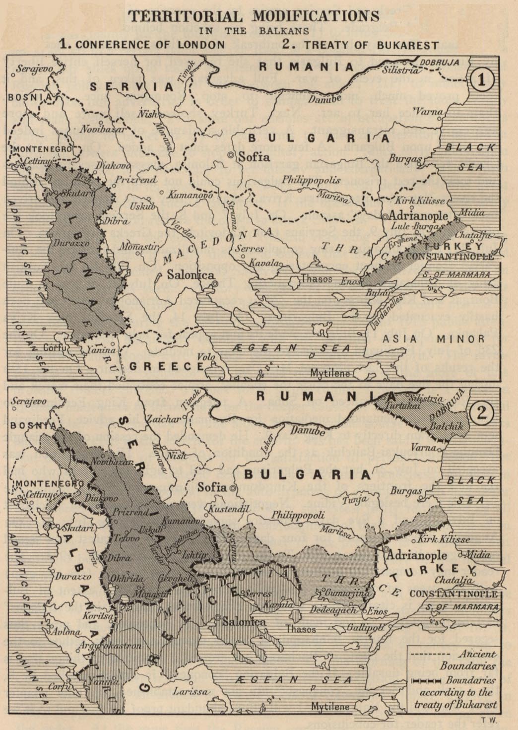
The mainland area of Evros was fought over in the Balkan Wars and in the First World War between the Ottoman Empire or Turkey, Bulgaria and Greece and was placed under new rule by various international treaties. It fell to Bulgaria through the Treaty of London (1913) , was in the same year for a short time under the Provisional Government of Western Thrace formed by Turks , was then Bulgarian again ( Peace of Bucharest , 1913), fell under the administration of France for after the First World War the Entente ( Treaty of Neuilly-sur-Seine , 1919) and shortly afterwards to Greece ( Treaty of Sèvres , 1920), what after the Greco-Turkish War by the Treaty of Lausanne (1923) (but without a small area around the village Karaağaç on the right side of the Evros, across from Edirne) was finally confirmed.
However, the north of the prefecture with Didymoticho and the region around today's Orestiada had initially developed differently than Alexandroupoli in the south. During the First Balkan War of 1912-13 was by the Treaty of London (1913) initially fell next to Alexandroupoli and Western Thrace also Didymoticho and left Evros banks of Bulgaria, as a result of the Second Balkan War, the region fell by Didymoticho by the Treaty of Bucharest , however, back to the Ottomans. It was not until 1915 that the Ottoman Empire finally ceded the left bank of the Evros (about the northern half of today's prefecture) including Didymoticho to the Bulgarians in order to persuade them to join the Central Powers in the First World War. After the defeat of the Central Powers in 1919 all of Western Thrace, including Alexandroupoli and Didymoticho, fell to Greece. The region remained in World War II, as most of the prefecture as an enclave, unlike western Thrace and eastern Macedonia, came under German rather than Bulgarian military administration, while Bulgaria annexed western Thrace and eastern Macedonia in 1941-1944.

On March 3, 1943, around 1250 Jews in the region were arrested and five days later transported to the Treblinka extermination camp , including three Jews from the island of Samothraki. Apart from 40 people who escaped the transport in Nea Orestia and 33 others who escaped deportation in Didymoticho, all Jews of Evros were murdered during the Second World War.
The changed political situation after the Second World War and the Greek Civil War made Evros in central Thrace permanently a peripheral and border area. As an area in the extreme northeast of Greece, Evros formed both the border region to the arch enemy Turkey and the northeast outpost of the "Free World" before the communist Eastern Bloc . The borders were heavily fortified, including with countless landmines that were poorly mapped and therefore have not yet been completely removed. Officials counted eight dead and nine injured by landmines in 2004. The relationship with Bulgaria has improved considerably since the 1990s and with the entry of Bulgaria into the EU, also in the exchange between the border regions.The border with Turkey is (also as the external border of the EU) - despite the mutual rapprochement between the two states since Turn of the millennium - still strongly secured.
politics

At the prefecture level, the 25-person prefectural council and (since 2002) prefect Nikolaos Zambounidis (Νικόλαος Ζαμπουνίδης, PASOK ) were responsible for the areas of trade, health, veterinary and agriculture. At the same time, Evros and the neighboring Rodopi formed an "over-prefecture" ( Greek Υπερνομαρχία ), for which an "over-prefect" ( Greek Υπερνομάρχης ), officially the "chairman of the prefectural self-government" ( Greek Πρόεδροης ) was directly elected by the people ίττκαδοαης τίτης Πρόεδρος Νομης . In 2006 Georgios Minopoulos (Γεώργιος Μηνόπουλος, also PASOK) was elected to this office. The two 25-member prefectural councils together formed the council for the “over-prefecture”. The socialist PASOK had 30 members in this council and 20 members of the conservative ND .
seal
The prefecture's seal was two-tone blue and white. It showed a picture of the Nike of Samothrace ; in the edge was the inscription " Greek ΝΟΜΟΣ ΕΒΡΟΥ · Ο ΠΡΩΤΟΣ ΣΤΗΝ ΕΛΛΑΔΑ " ("Prefecture of Evros, the first in Greece") .
Administrative division
The area of the prefecture belonged in the Ottoman Empire from 1874 to the Sandschaks Edirne and Dedeağaç des Vilâyet Edirne. It was not until the wars of the early 20th century that the Evros became a border river. The French occupation divided the mainland into three districts, which correspond to today's prefectural boundaries, the district of Dedeagatch in turn into four districts, which were in the mainland provinces ( Greek επαρχίες eparchíes : Alexandroupoli, Didymoticho, Orestiada and Soufli ) of the prefecture after the takeover of the area continued to exist by the Greek state in 1920. Samothrace was added as the fifth province. At the local level seven churches existed ( Greek δήμοι Dimi , singular Dimos δήμος) and 73 rural communities or "rural communities" (Kinotites) . With the municipal reform of 1997 these municipalities were combined into thirteen municipalities, which comprise a total of 176 settlements. In 2011, these thirteen municipalities were merged into five large municipalities, which correspond by name to the five former provinces, but some have different boundaries.
Larger cities are the former capital Alexandroupoli on the coast with 48,885 inhabitants and the small town Orestiada with 15,246 inhabitants, which forms the center of the northern plain, larger settlements are also the rural towns of Feres (5206 inhabitants) and Soufli (4258 inhabitants).

|
No. | local community | Area ( km² ) |
Pop. | Seat | Pop. | Villages (Ew.) |
|---|---|---|---|---|---|---|---|
| 1 | Alexandroupoli (Αλεξανδρούπολη) | 642.25 | 52,720 | Alexandroupoli | 48,885 | Makri (820) | |
| 2 | Vyssa (Βύσσα) | 170.18 | 8,184 | Nea Vyssa (Νέα Βύσσα) | 2,844 | Kastanies (1,295) Kavyli (1,494) Rizia (1,684) Sterna (867) |
|
| 3 | Didymoticho (Διδυμότειχο) | 335.88 | 18,998 | Didymoticho | 8,799 | Koufovouno (958) Lagos (1,403) Sofiko (926) |
|
| 4th | Kyprinos (Κυπρίνος) | 97.19 | 2,915 | Kyprinos | 1,157 | Filakio | |
| 5 | Metaxades (Μεταξάδες) | 211.24 | 4,486 | Metaxades | 874 | ||
| 6th | Orestiada (Ορεστιάδα) | 245.24 | 21,730 | Orestiada | 15,246 | Neochori (1,159) | |
| 7th | Orfeas (Ορφέας) | 643.27 | 6,146 | Lavara (Λάβαρα) | 1,580 | Amorio | |
| 8th | Samothrace (Σαμοθράκη) | 177.98 | 2,723 | Samothrace | 677 | ||
| 9 | Soufli (Σουφλί) | 462.05 | 7,519 | Soufli | 4,258 | Dadia (800) | |
| 10 | Traianoupoli (Τραϊανούπολη) | 163.55 | 3,335 | Anthia (Άνθεια) | 862 | Loutros (1,049) | |
| 11 | Trigono (Τρίγωνο) | 372.26 | 6,656 | Dikea (Δίκαια) | 797 | Ormenio (807) | |
| 12 | Tychero (Τυχερό) | 220.41 | 4,103 | Tychero | 2,031 | ||
| 13 | Feres (Φέρες) | 411.16 | 9,839 | Feres | 5,206 | Peplos (1,083) |
Economy and Infrastructure
The prefecture was one of the economically more backward regions of Greece.
Agriculture
Evros is traditionally shaped by agriculture. Around 1504 km², i.e. a good 35% of the area of the prefecture and a good 80% of the agriculturally usable area, are built on. The plowed area is around 143,000 hectares: Grain (mainly maize), pulses and vegetables are grown on the mainland. In addition, sunflowers and sesame seeds for oil production as well as sugar beet are cultivated in the area of Orestiada with increasing tendency, in the northern plain there are some sugar factories. Tobacco and cotton are also grown. Fruit growing also plays a role. Around 2700 hectares of land are cultivated on a permanent basis. Around 145 hectares of cultivated land are still used for private use.
Thracian viticulture has been documented since ancient times and today plays a small but growing role in the prefecture of Evros with just under 280 hectares (8% of the vineyard area in Eastern Macedonia and Thrace, 0.35% of the vineyard area in Greece).
Around 4,350 hectares are used permanently as pasture, primarily for sheep, goats and cows. Evros is one of the few prefectures in Greece with significant cow's milk production, which, however, like all livestock farming, is declining.
Samothrace is characterized by olive cultivation and oil production. 2112.5 hectares are planted with olive trees in the whole of Evros, which makes up 18.3% of the olive cultivation of Eastern Macedonia and Thrace. Fruit, fruit products and honey are also represented on Samothrace. Various sheep's milk cheeses are among the island's specialties.
Silk production
In the year 555 the knowledge about silk production as well as some eggs of the silk moth came to the Byzantine Empire. Obviously, relatively soon afterwards, silkworms were bred on the Evros river, the area is considered the oldest European site for silk production. With the industrial revolution and the connection to the Dedeağaç – Edirne railway in 1872, the town of Soufli became a flourishing center of silk spinning. The production grew after the turn of the 20th century to up to 40 tons of silk thread annually. Almost the entire population lived from silk production, mulberry forests shaped the banks of the Evros. With the loss of the hinterland on the left Evros side in 1923 and the development of industrial synthetic fibers, this branch of industry lost its importance dramatically, today around 50 people are still employed in silk production. A museum in Soufli is now dedicated to documenting this branch of the economy.
fishing
Fisheries are not a significant commercial factor in the prefecture. Nevertheless, fish and seafood are caught both in the overfished Aegean Sea and in the freshwater area of the Evros Delta. The Evros is also the original habitat of the European sturgeon , from which caviar was obtained. After the fish species disappeared in 1975, caviar production was discontinued, but specimens have been found again in Evros in recent years, fueling the hope of caviar production in farms.
Industry
The main industry in Evros is the food processing industry. There is also a modest textile production facility, which is still partly handcrafted. Basalt and granite are mined on Samothrace .
Evros is also the location of two large-scale energy supply projects. In 2007, a 285 km long gas pipeline was completed between Karacabey in Turkey and Komotini, which is to be extended to Stavrolimenas on the Greek west coast and under the Ionian Sea to Italy as part of the Southern European Gas Ring Project . This connects the European gas network to the Caspian producing countries, bypassing Russia. At the border town of Kipi there is a compressor station for this gas pipeline. In 2007, the construction of the Burgas-Alexandroupolis oil pipeline was decided as a Russian-Bulgarian-Greek project , which enables Russia to access the Mediterranean without crossing the territory of Turkey on the Bosporus.
Tourism and tourism

On the mainland, eco , agro and nature tourism play a role. The two nature reserves in the Evros Delta and in the forest of Dadia are particularly important here, but also farms and farms. In the national area, there is Loutros in the municipality of Traianoupoli, a classic health resort that has medicinal springs; Therapeutic riding is offered in the municipality of Tychero. Alexandroupoli has also established itself as a congress city for the domestic Greek economy in recent years. The Byzantine churches also play a role in religious tourism.
Samothraki's importance for traditional summer tourism in Greece has increased in recent years; the tourist infrastructure here is significantly more developed than on the mainland. The Kabiren sanctuary is also the most important ancient archaeological site in the prefecture for tourism. There is also alpine and hiking tourism, especially the mountain regions of the Fengari are the goal here.
traffic


The Via Egnatia , the main trade connection across the Balkans to Byzantium , ran along the coast of the prefecture area as early as Roman times . This course is basically followed by the modern Greek Autobahn 2 , which, like the older National Road 2, runs parallel to the coast as an east-west connection. The second important road connection is the national road 51 , which goes up the Evros on the right and connects the coast with the hinterland and further with Edirne and the Bulgarian Thrace.
Evros was connected to rail traffic in 1870 with the construction of the Thessaloniki – Istanbul railway line, from which a branch line branches off up the Evros Valley, which also connected the city of Edirne to the rail network with Karaağaç station, but no longer exists today. Since the gap in the connection in Greek territory was closed in 1971, the route along the Evros has led back to Bulgaria via Ormenio in the direction of Plovdiv . The branch on this route, which continues via the border town of Pythio to Istanbul , is still used by two trains a day. The train routes are not electrified.
With the construction of the city of Dedeağaç (Alexandroupoli), the only larger port in today's prefecture was built there. There are regular ferry connections to the islands of Samothraki and Limnos .
Several national flights every day are handled via the Alexandroupoli "Dimokritos" International Airport ( Greek : Διεθνής Αερολιμένας Δημόκριτος , Diethnís Aerolimenas Dimokritos ), whose facility, built in 1975, is seven kilometers east of the capital.
education
School provision in Evros shows an urban-rural divide. All municipalities have at least one middle school ( Greek γυμνάσιο , Gymnasio , grades 7-9), high schools ( Greek λύκειο , Lykio , grades 10-12) are only in the larger municipalities. A total of 22 secondary and twelve secondary schools are available for Greek-speaking students, plus five vocational schools (in Alexandroupoli, Didymoticho and Orestiada) and one evening secondary and secondary school each in Alexandroupoli.
The Democritus University of Thrace , founded in 1973, has had two locations in the prefecture since the 1990s. The departments for medicine, molecular biology and genetics as well as educational sciences are located in Alexandroupoli; Orestiada is home to the Agricultural Development and Forestry, Environmental Management and Natural Resources departments.
School education for the Muslim minority
According to Articles 40 and 41 of the Lausanne Treaty, there are bilingual primary schools in the prefecture of Evros (singular Greek δημοτικό σχολείο , Dimotiko scholio , grades 1–6) for the education of the Muslim minority, in which classes are given in two languages (Greek and Turkish) . In 2003 there were 21 of these - mostly private - elementary schools in the prefecture. Since 1968, lessons for members of the minority have been regulated by bilateral agreements between Turkey and Greece as well as numerous other, sometimes contradicting, international agreements and ministerial decrees. The subjects Turkish, religion, mathematics, physics, chemistry and drawing are taught in Turkish by Muslims, while Greek, foreign languages, history, geography and environmental studies are taught in Greek by Christians. Physical education and music lessons are given in one language or another, depending on the circumstances. The Turkish textbooks are edited and printed in Turkey.
In all of Western Thrace there are only two secondary schools (middle and high school) for the Muslim minority, they are in Xanthi and Komotini , i.e. outside the prefecture. The low capacity of these schools and the distance from Evros mean that most of the students who continue their education after primary school do so in regular Greek state schools. Successful graduates of the two secondary schools for the minority can train to become teachers for subjects taught in Turkish at the Pedagogical Special Academy in Thessaloniki. Since 1996, a quota of 0.5% of students at Greek universities has had to belong to the Muslim minority. Members of the Muslim minority, however, on average have a lower level of education than members of the Greek-speaking majority. Less than half of the approximately 400 study places for Muslims created nationwide by the admission quota have so far been filled.
Web links
- alex.eled.duth.gr Extensive collection of articles on Western Thrace and Evros (Greek)
- www.evros.gr Website of the Alexandroupoli Development Association about Evros (Greek)
- www.dadia-np.gr Page of in the Dadia-Lefkimi-Soufli Forest National Park (accessed November 26, 2018)
Individual evidence
- ↑ Results of the 2011 census at the National Statistical Service of Greece (ΕΛ.ΣΤΑΤ) ( Memento from June 27, 2015 in the Internet Archive ) (Excel document, 2.6 MB)
- ↑ The area of the Rodopi-Evros prefecture in numbers ( Memento of the original from February 9, 2005 in the Internet Archive ) Info: The archive link was automatically inserted and not yet checked. Please check the original and archive link according to the instructions and then remove this notice. , Website of the super-prefecture (Greek)
- ^ Map of the 2005 floods on dartmouth.edu
- ↑ Andreas Matzarakis: The climate of Evros . Freiburg 2006, ISBN 3-00-020071-1 ( urbanclimate.net [PDF]).
- ↑ Entry ( page no longer available , search in web archives ) Info: The link was automatically marked as defective. Please check the link according to the instructions and then remove this notice. on the website of the World Conservation Monitoring Center
- ↑ Evros National Park to 'ecological disaster' ( page no longer available , search in web archives ) Info: The link was automatically marked as defective. Please check the link according to the instructions and then remove this notice. , ekathemerini.com, November 15, 2005 (English)
- ↑ Entry ( page no longer available , search in web archives ) Info: The link was automatically marked as defective. Please check the link according to the instructions and then remove this notice. on the website of the World Conservation Monitoring Center
- ↑ Mike Liebscher: Greece. Natural travel guide . Münster, ISBN 3-931587-82-7 .
- ↑ Results of the 2011 census at the National Statistical Service of Greece (ΕΛ.ΣΤΑΤ) ( Memento from June 27, 2015 in the Internet Archive ) (Excel document, 2.6 MB)
- ↑ The area of the Rodopi-Evros prefecture in numbers ( Memento of the original from February 9, 2005 in the Internet Archive ) Info: The archive link was automatically inserted and not yet checked. Please check the original and archive link according to the instructions and then remove this notice. , Website of the super-prefecture (Greek)
- ↑ a b Thanasis Vakalios: Το προβλήμα της διαπολιτισμικής εκπαίδευσης στη Δυτική Θράκη . Gutenberg, Athens 1997 .; Quoted in: Shireen Hunter: Islam, Europe's Second Religion: The New Social, Cultural, and Political Landscape . Praeger / Greenwood, 2002, ISBN 0-275-97609-2 , pp. 177 .
- ↑ Overview of the Greek dioceses on the pages of the Greek Church (gr.)
- ^ Richard Clogg (Ed.): Minorities in Greece: Aspects of a Plural Society . Hurst, London 2002, ISBN 1-85065-705-X , pp. 84 .
- ↑ Report of the Greek Ministry of Foreign Affairs on the situation of Muslims in Greece (English)
- ↑ Christoph Pan: The minority rights in Greece . Ed .: Christoph Pan, Beate Sibylle Pfeil = collective work = minority rights in Europe. Handbook of European Ethnic Groups. tape 2 . Vienna 2006, ISBN 978-3-211-35307-3 , pp. 196 ff .
- ↑ George X. Kalantzis: Outcomes of the First World War in South Eastern Europe: Population Movements in Western Thrace During the Inter-Allied Administration . In: Études Balkaniques . No. 3 . Sofia 2004, p. 24-41 .
- ↑ The area of Karaağaç, which fell to Turkey in 1923, is included here.
- ↑ Agreement on population exchange between Greece and Turkey (English)
- ^ Richard Clogg (Ed.): Minorities in Greece: Aspects of a Plural Society . Hurst, London 2002, ISBN 1-85065-705-X , pp. 95 .
- ↑ The Evros: A perilous crossing on the threshold of Europe ( Memento of the original from February 1, 2014 in the Internet Archive ) Info: The archive link was inserted automatically and has not yet been checked. Please check the original and archive link according to the instructions and then remove this notice. ekathimerini.com, September 24, 2003 (English)
- ↑ 12 bodies found in Evros River ( Memento of the original dated February 1, 2014 in the Internet Archive ) Info: The archive link was inserted automatically and has not yet been checked. Please check the original and archive link according to the instructions and then remove this notice. , ekathemerini.com, September 10, 2003 (English)
- ↑ Evros region is now one of the main entry points for clandestine immigrants from Middle East and Asia ( Memento of the original of October 30, 2010 in the Internet Archive ) Info: The archive link was automatically inserted and not yet checked. Please check the original and archive link according to the instructions and then remove this notice. , ekathimerini.com, July 7, 2007 (English)
- ↑ Ann Löwin, “Digging at the Border,” Jungle World, No. 33, Aug. 18, 2011
- ↑ Video Grenzzaun am Evros is in the ZDFmediathek , accessed on January 26, 2014. (offline)
- ^ Territorial Modifications in the Balkans by the Conference of London and the Treaty of Bucharest (map)
- ↑ Chronology (1915) ( Memento of the original of July 23, 2007 in the Internet Archive ) Info: The archive link was automatically inserted and not yet checked. Please check the original and archive link according to the instructions and then remove this notice.
- ^ Henry Morgenthau: Ambassador Morgenthau's Story - How Turkey Bribed Bulgaria to Join the Central Powers, 1915, pp. 185-188. Wayne State U. Press, 2003 (first published in 1918; dedicated to Woodrow Wilson)
- ^ Martin Gilbert: The Routledge Atlas of the Holocaust = edition = 3 . Routledge, London / New York 2002, ISBN 0-415-28145-8 , pp. 150 f .
- ↑ Information from www. resistance-repression-griechenland.de ( Memento of the original from April 7, 2008 in the Internet Archive ) Info: The archive link was inserted automatically and has not yet been checked. Please check the original and archive link according to the instructions and then remove this notice.
- ↑ Page of the Rodopi-Evros Prefecture (Greek)
- ↑ Election result ( Memento of the original from April 19, 2011 in the Internet Archive ) Info: The archive link was inserted automatically and has not yet been checked. Please check the original and archive link according to the instructions and then remove this notice. (Greek)
- ↑ Explanations and map of the Vilayet Edirne at sephardicstudies.org
- ↑ Thrace in europewine.com
- ↑ Information from the Rodopi-Evros Prefecture ( Memento of the original dated February 11, 2005 in the Internet Archive ) Info: The archive link was automatically inserted and not yet checked. Please check the original and archive link according to the instructions and then remove this notice. (Greek)
- ↑ Article about silk production ( Memento of the original from October 5, 2007 in the Internet Archive ) Info: The archive link has been inserted automatically and has not yet been checked. Please check the original and archive link according to the instructions and then remove this notice. in the German-language magazine nea fon , issue 01-2003 (PDF; 677 kB)
- ↑ Portrait of the museum on the sponsor's pages (Greek)
- ↑ History of Soufli and silk production ( Memento of the original from November 5, 2010 in the Internet Archive ) Info: The archive link was inserted automatically and has not yet been checked. Please check the original and archive link according to the instructions and then remove this notice. on the pages of the Soufli High School (Greek)
- ↑ PS Economidis, E. Th. Koutrakis, DC Bobori: Distribution and conservation of Acipenser sturio L., 1758 and related specieas in Greek waters . 1999 ( ieo.es [PDF]). Distribution and conservation of Acipenser sturio L., 1758 and related specieas in Greek waters ( Memento of the original from November 15, 2008 in the Internet Archive ) Info: The archive link was automatically inserted and not yet checked. Please check the original and archive link according to the instructions and then remove this notice.
- ↑ epirus-news ( Memento of the original from January 9, 2008 in the Internet Archive ) Info: The archive link was inserted automatically and has not yet been checked. Please check the original and archive link according to the instructions and then remove this notice.
- ^ South East European Times, November 19, 2007
- ↑ Caspian gas begins to flow in the Turkish-Greek pipeline euraktiv.com, November 19, 2007
- ↑ Map of the gas ring in Greece ( page no longer available , search in web archives ) Info: The link was automatically marked as defective. Please check the link according to the instructions and then remove this notice.
- ↑ Report in Novosti , September 4, 2006
- ↑ Page about tourism in the prefecture ( Memento of the original from December 4, 2011 in the Internet Archive ) Info: The archive link has been inserted automatically and has not yet been checked. Please check the original and archive link according to the instructions and then remove this notice. on the official website of the prefecture (Greek)
- ↑ Web presence ( Memento of the original from January 15, 2008 in the Internet Archive ) Info: The archive link was inserted automatically and has not yet been checked. Please check the original and archive link according to the instructions and then remove this notice. of the airport
- ↑ Map ( Memento of the original from June 27, 2007 in the Internet Archive ) Info: The archive link was inserted automatically and has not yet been checked. Please check the original and archive link according to the instructions and then remove this notice. of the rail network around Edirne (GIF)
- ↑ Timetable of the Turkish train connections to Europe at the Turkish State Railways
- ↑ Directory of secondary schools in the prefecture ( Memento of the original from June 29, 2007 in the Internet Archive ) Info: The archive link has been inserted automatically and has not yet been checked. Please check the original and archive link according to the instructions and then remove this notice. (Greek)
- ↑ University website ( Memento of the original from January 8, 2008 in the Internet Archive ) Info: The archive link was inserted automatically and has not yet been checked. Please check the original and archive link according to the instructions and then remove this notice. (Greek)
- ↑ Richard Potz, Wolfgang Wieshaider (ed.): Islam and the European Union . Peeters, Löwen 2004, p. 96 ff .
Achaia | Argolis | Arcadia | Arta | Athens | Aetolia-Acarnania | Boiotia | Halkidiki | Chania | Chios | Dodecanese | Drama | Elis | Euboea | Evrytania | Evros | Florina | Fokida | Fthiotida | Grevena | Imathia | Ioannina | Heraklion | Karditsa | Kastoria | Kavala | Kefallinia | Kilkis | Kerkyra | Corinthia | Kozani | Cyclades | Laconia | Larisa | Lasithi | Lefkada | Lesbos | Magnesia | Messenia | Pella | Ostattika | Pieria | Piraeus | Preveza | Rethymno | Rodopi | Samos | Serres | Thesprotia | Thessaloniki | Trikala | West Attica | Xanthi | Zakynthos