Ferghana Mountains
| Ferghana Mountains | ||
|---|---|---|
| Highest peak | Uchsejit ( 4940 m ) | |
| location | Kyrgyzstan | |
| part of | Tienschan | |
|
|
||
| Coordinates | 41 ° 0 ′ N , 73 ° 56 ′ E | |
| rock | Mica schist , sandstone , limestone | |
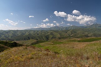
The Ferghana Mountains ( Kyrgyz Фергана тоо кыркасы ) is a mountain range of the Tien Shan in Kyrgyzstan in Central Asia .
The Ferghana Mountains separate the lowlands of the Ferghana Valley in the west from the Inner Tien Shan in the east. It has a longitudinal extent in northwest-southeast direction of 225 km. The southeastern part of the mountain is glaciated and is higher than the northwestern part. The glacier area is given as 125 km². The maximum altitude is 4940 m . The Ferghanagebirge drops steeply to the northeast, while the mountain slopes are flat to the southwest. In the southeast the mountain ranges of the Torugart and Alai mountains join. The foothills of the Ferghana Mountains are Babasch-Ata , Suugan-Tasch , Sjorjun-Djobjo and the Sklony Mountains . Larger watercourses that drain the Ferghana Mountains are the Karakuldscha , Karaüngkür , Kulun , Jassy and Alabuga rivers .
The mountains consist of mica schist as well as sandstone , limestone and other sedimentary rocks. There are intrusions of gabbro and diabase .
Individual evidence
- ↑ a b Article Ferghanagebirge in the Great Soviet Encyclopedia (BSE) , 3rd edition 1969–1978 (Russian)
- ↑ advantour.com

