Fernandópolis
| Município de Fernandópolis Fernandópolis |
|||
|---|---|---|---|
|
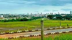
Panoramic view of Fernandópolis
|
|||
|
|
|||
| Coordinates | 20 ° 17 ′ S , 50 ° 15 ′ W | ||
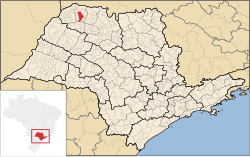
 Location of the municipality in the state of São Paulo Location of the municipality in the state of São Paulo
|
|||
| Symbols | |||
|
|||
| founding | May 22, 1939 (foundation) (age 81) January 1, 1945 (town charter ) (age 75) |
||
| Basic data | |||
| Country | Brazil | ||
| State | São Paulo | ||
| ISO 3166-2 | BR-SP | ||
| climate | tropical, Aw | ||
| surface | 549.8 km² | ||
| Residents | 64,696 (2010) | ||
| density | 117.7 Ew. / km² | ||
| estimate | 69,116 (July 1, 2019) | ||
| Parish code | IBGE : 3515509 | ||
| Post Code | 15600-000 | ||
| Telephone code | (+55) 17th | ||
| Time zone | UTC −3 | ||
| Website | fernandopolis.sp (Brazilian Portuguese) | ||
| politics | |||
| City Prefect | André Giovani Pessuto Candido (2017-2020) | ||
| Political party | Democratas | ||
| Culture | |||
| City festival | May 22nd (founding day) | ||
| economy | |||
| GDP | 1,975,540 thousand R $ 28,883 R $ per person (2016) |
||
| HDI | 0.797 (high) (2010) | ||
|
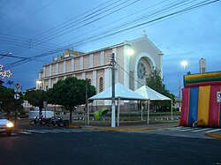
Main church
|
|||
Fernandópolis , officially Portuguese Município de Fernandópolis , is a municipality in the Brazilian state of São Paulo . The population was estimated at 1 July 2019 69,116 residents who live in a community km² area of about 549.8 and Fernandopolenser ( fernandopolenses ) are called. The population density is 118 people per km². It ranks 104th of the state's 645 municipalities and is 554 km northwest of the capital, São Paulo , accessible via the SP-320 , SP-527 and SP-543 roads .
geography
Surrounding communities are Macedônia , Pedranópolis , Meridiano , São João das Duas Pontes , Guarani d'Oeste , São João de Iracema and Estrela d'Oeste .
climate
The community has a tropical climate, Aw according to the Köppen and Geiger climate classification . The average temperature is 22.3 ° C. The average amount of precipitation is 1235 mm per year, the southern summer has more rainfall than the southern winter.
Population development
| year | Residents | city | country |
|---|---|---|---|
| 1991 | 56,144 | 52.022 | 4.122 |
| 2000 | 61,647 | 59,143 | 2,504 |
| 2010 | 64,696 | 62.714 | 1,986 |
| 2019 | 69,116 | ||
 |
|||
Source: IBGE (2011)
Average income and standard of living
In 2017, the monthly average income was 2.1 times the Brazilian minimum wage ( Salário mínimo ) of R $ 880.00 (converted for 2019: around € 418). The Human Development Index (HDI) is rated high at 0.797 for 2010.
The gross national product per capita in 2016 was R $ 28,882.59.
sons and daughters of the town
- Argemiro de Azevedo (* 1952), Bishop of Assis
- Weligton (* 1979), football player
- João Paulo Sales de Souza (* 1988), football player
- Johnathan Aparecido da Silva (* 1990), football player
Web links
Individual evidence
- ↑ a b Fernandópolis climate: Weather, average temperature, & climate diagram for Fernandópolis. In: de.climate-data.org. Retrieved November 1, 2019 .
- ↑ a b c Fernandópolis - Panorama. In: cidades.ibge.gov.br. IBGE , accessed November 1, 2019 (Brazilian Portuguese).
- ↑ André Pessuto 25 (Prefeito). In: todapolitica.com. Eleições 2016, accessed November 1, 2019 (Brazilian Portuguese).
- ↑ Evolução da divisão territorial do Brasil 1872-2010 (= IBGE [Ed.]: Documentos para disseminação. Memória institucional . No. 17 ). 2011, ISBN 978-85-240-4208-9 , ISSN 0103-6459 , Evolução da população, segundo os municípios - 1872/2010, p. 230 (Brazilian Portuguese, ibge.gov.br [PDF; 122.3 MB ; accessed on October 29, 2019]).
- ^ Atlas do Desenvolvimento Humano do Brasil: Fernandópolis, SP . Retrieved November 1, 2019 (Brazilian Portuguese).


