Reggio Emilia Airport
| Reggio Emilia Airport Aeroporto di Reggio Emilia “Ferdinando Bonazzi” |
|
|---|---|

|
|
| Characteristics | |
| ICAO code | LIDE |
| IATA code | ZRO |
| Coordinates | |
| Height above MSL | 46 m (151 ft ) |
| Transport links | |
| Distance from the city center | 2 km east of Reggio Emilia |
| Street | Via dell'Aeronautica, 15 (SS 468), SS 9 |
| Local transport | bus |
| Basic data | |
| opening | 1930 |
| operator | Aeroporto Reggio Emilia SpA |
| Start-and runway | |
| 11/29 | 1212 m × 30 m asphalt |
The Reggio Emilia airport ( it .: Aeroporto di Reggio Emilia “Città del Tricolore - Ferdinando Bonazzi” ) is located in the northern Italian region of Emilia-Romagna , around two kilometers east of Reggio nell'Emilia . The airfield is mainly used by general aviation , but it is also open to regional commercial traffic.
Infrastructure and use
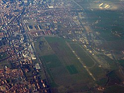
The airport has an asphalt runway (11/29) that is around 1200 meters long and runs parallel to the Tangenziale Nord north bypass ( state road 9 ) and the Milan – Bologna railway line in the south. To the north of the runway there are two separate aprons , one of which is mainly used by the local Reggio Emilia Aeroclub , while the other is also available for commercial air traffic. In between is the tower .
Via dell'Aeronautica , the airport is connected to the northern bypass of Reggio Emilia and to the old Via Emilia (SS9), which can also be used to reach the city center, including the number 10 bus. A little more than a kilometer west of the airport The Reggio train station is located, and the A1 motorway passes around three kilometers north of the airport . The nearest major commercial airports are Parma in the west and Bologna in the east.
history
Since 1916, there has been a racecourse on today's airfield site , which was also used as an airfield. With a ministerial decree of November 12, 1930, the establishment of an official airfield was decided, which was established in the following years. The main users were the Reggiane works, which mainly built fighter planes for the Regia Aeronautica here. The use as a factory airfield was in the foreground during the Second World War until 1942, when the airfield was used by Italian and German squadrons, including the Jagdgeschwader 53 and the Aeronautica Nazionale Repubblicana . In September 1944, German units destroyed the airfield because of the feared Allied breakthrough of the Goths .
After the war, the airfield was restored for air sports purposes and, after various expansion works, was opened to commercial traffic in 1997. The desired economic success failed to materialize because the Emilia-Romagna region, with Parma, Bologna, Rimini and Forlì, has a traffic airport density that is far above requirements. The airfield has been used regularly as a concert venue since the early 1980s.
Web links
- Airport data on World Aero Data ( 2006 )
- Official website (English / Italian)
- Presentation on the website of the City of Reggio Emilia
- Website of the Aeroclub Reggio Emilia