
Fort IX of the Warsaw Fortress

The Fort IX of Warsaw Fortress (also called Fort "Czerniaków" "Dąbrowskiego" or "Sadyba") is one of the 19 artillery cont of the outer ring of the defense Warsaw Fortress . It is located in Sadyba, a residential area in the Mokotów district of Warsaw . The complex was built at the end of the 19th century and now houses two museums. It is located on Powsińska Street and was listed as a historical monument in March 1973 with registration number 807.
structure
The fort, which was built in the classic shape of a pentagon, is surrounded by the small streets Morszyńska and Okrężna, including its former rear space, which is now used as a park and school grounds. The main thoroughfare Powsińska, an extension of the western Vistula bank road and which today leads directly past the brick casemates of the fort, cuts through the former fort by a third. The fort was surrounded by a moat, most of which still exists today. A steel bridge served as access on the valley side , the remains of which are still there. Today it is accessed from Powsińska Street, which crosses the moat twice.
history
The fort, which was built in 1883 for Russian troops stationed in the Vistula of the Russian Empire , was part of the outer defensive ring of the Warsaw Fortress and was located between forts VIII ("Służew") and X ("Augustówka") . The main direction of defense was to the southeast in the direction of Wilanów Castle, which was about two kilometers away . When the fortress was abandoned and partially destroyed in 1913, a large part of the bunkers and barracks were blown up, with the remaining casemates receiving part of their splinters that still exist today. In 1921 the rest of the fort was named after the Polish general Jan Henryk Dąbrowski .
On the former esplanade of the fort, houses for deserving officers of the Polish army were built from 1924 by a building cooperative. The buildings were planned by Tadeusz Tołwiński and Oskar Sosnowski and were optically based on the Polish house architecture of the 18th and 19th centuries. The master plan for the development of the area around the fortress was based on Ebenezer Howard's ideas for a garden city . By the outbreak of World War II , around 30 buildings were built here along the newly created Okrężna and Morszyńska streets, which formed the basis of what would later become the Sadyba district.
On the rear of the former fort, next to the part of the park west of Powsińska Street, primary school no.115 (now named after Wanda Turowska ) was built on September 1, 1933 - initially as a temporary wooden structure, and since 1955 as a three-story brick building. In 1935, Powsińska Street was built to connect Wilanów through the southern tip of the fort. Motor vehicles and a tram that no longer exists here ran here. In 1936 a park was created on the rear site of the fort, which was later named after the officer Czesław Szczubełek.
Second World War
As part of the defensive battles during the German invasion of Poland in September 1939, the fort was the defensive position of a Polish unit that consisted of a volunteer company and parts of the 2nd Battalion of the 360th Infantry Regiment. On September 26th, the fort was captured by German troops, 20 Polish defenders were killed. The former Olympic champion Janusz Kusociński was wounded during these fights .
During the Warsaw Uprising in 1944, Polish forces - under the leadership of Szczubełek - had established themselves in the fort. On September 1, 1944 at 5:00 p.m., a German bomb hit a room in the casemates where part of the AK battalion “Oaza” ( 5th region, 5th district ) was staying at the time. 16 soldiers died.
During the fighting of the Second World War, part of the officers' villas surrounding the fort were destroyed. In 1958, 13 new buildings were built in their place by the Stanisław Nowakowski Housing Cooperative . Many of the remaining villas were later converted. Only a few of the villas have retained their original appearance to this day. After the war, the area of the fort located east of Powsińska Street was transformed into a small park, while the western part was used by the Polish Army until 1990.
Branch of the Army Museum
In 1989 a memorial stone was unveiled next to the fort in memory of Janusz Kusociński. Since the beginning of the 1990s, the fort served as a warehouse for the Polish Army Museum located in the city center . At the end of the 1990s, the Muzeum Polskiej Techniki Wojskowej and the Katyń Museum Warsaw were opened here as branches of the Army Museum. The future use of the fort after the planned closure of the two museums as part of a new museum building in the Warsaw Citadel is uncertain.
Views of the Czerniaków Fort
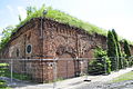
East side of the casemates, now on Powsińska Street
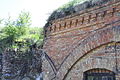
Partly collapsed brick casemates

View from the moat on the north flank

Remains of the earlier steel bridge on the valley side


References and comments
- ↑ Czerniaków is a former village, today part of the Mokotów district north of Sadyba
- ↑ a b c according to Information Fort IX "Czerniakowski" ( Memento of the original from December 9, 2010 in the Internet Archive ) Info: The archive link was automatically inserted and not yet checked. Please check the original and archive link according to the instructions and then remove this notice. on the website of the City of Warsaw from October 19, 2009 (in Polish)
- ^ Tadeusz Tołwiński (1887–1951) was a Polish architect and urban planner, a representative of neo-baroque and modern times and professor at the Warsaw University of Technology
- ^ Oskar Sosnowski (1880-1939) was a Polish architect, monument protector and university professor
- ↑ according to Historia Szkoły Podstawowej nr 115 at Sadyba.waw.pl (in Polish)
- ↑ Melchior Czesław Szczubełek (1905–1944) was a doctor (internist) and captain of the Polish army and a member of the Home Army in the Warsaw Uprising
- ↑ Among them the company commander, Captain Jaszczur, according to Janusz Piekałkiewicz , Battle for Warsaw. Stalin's betrayal of the Polish Home Army in 1944 , FA Herbig Verlagbuchhandlung, ISBN 3-7766-1699-7 , Munich 1994, p. 167
Web links

Fortresses from the 19th century in Warsaw, Modlin and Zegrze
("Polish Fortress Triangle")
Fortress Modlin :
Citadel
Fort of the inner defense ring:
I |
II |
III |
IV |
V |
VI |
VII |
VIII
Fort of the outer defensive ring:
IX |
D-1 |
D-2 |
X |
D-3 |
XI |
D-4 |
XII |
XIII |
D-5 |
D-6 |
Fort group “Goławice” ( XIVb ) |
XIV |
Fort group “Carski Dar” (XV)
XVI |
D-7 |
D-8 |
Fort group "Janówek" ( D-9 , XVII ) |
D-10 |
XVIII
Warsaw Fortress :
Citadel Citadel
forts:
Nadbrzeżna Battery |
Fort Siergieja |
Fort Gieorgija |
Fort Pawła |
Fort Aleksieja |
Fort Władimira |
Fort Śliwickiego
Fort of the inner defense ring:
P |
W |
W-Tscha |
Tscha |
Tscha-M |
M |
M-Chee |
Che
forts of the outer defensive ring:
I |
II |
IIA |
III |
IV |
V |
VI |
VII |
VIIA |
VIII |
IX |
X |
XI |
XIA |
XII |
XIIA |
XIII |
XIV |
XIVA
Zegrze Fortress :
Great Festivals |
Small celebrations
Other forts:
Fort Beniaminów |
Fort Dębe |
Fort Kawęczyn |
Fort Łomianki |
Fort Maciołki |
Fort Pustelniki |
Fort Wawer
Coordinates: 52 ° 10 ′ 57 ″ N , 21 ° 3 ′ 59 ″ E