
Warsaw Fortress (19th century)

The Warsaw Fortress ( Polish "Twierdza Warszawa" ; Russian "крепость Варшава" ) was built in Warsaw in the 19th century . The defenses, which were mainly built on the west side of the Vistula , were built during the period when Warsaw was part of the Russian Empire . They served to secure the Russian empire against the great western powers and to maintain power against Polish strivings for independence, which became apparent in the November uprising of 1830/31 and the January uprising of 1863/64.
history
The fortress consisted of the citadel, built from 1832, with the five forts surrounding it on the west side and Fort Śliwickiego on the east bank of the Vistula . Analogous to the structure of the Antwerp fortress , which was used as a model, there was also an inner defensive belt, which consisted of eight forts. The outer defensive ring consisted of another 19 forts.
As early as 1840, the Russian rulers began to modernize the citadel and strengthen it with connected forts (including a bridgehead fort on the east side of the Vistula). In 1871 it was decided to expand the existing fortifications in Warsaw and Modlin ( fortress Modlin ) with a fortress to be built in Zegrze with intermediate artillery fortifications to form a greater Warsaw fortification . From 1882 the outer fort belt was built in Warsaw. These forts were built about six to twelve kilometers from the citadel. From 1886 to 1890 the inner fort belt was built at a distance of about four to ten kilometers from the citadel and thus about two kilometers from the forts of the outer belt. In the years 1890 to 1892 the citadel was reinforced by concrete intermediate structures and capons . The casemates and camps of the outer fort were also partially covered with concrete. In the meantime the explosive grenade was invented; it had a more powerful explosive effect than conventional grenades and made it possible to "shoot down" walled fortresses. The last construction work on the forts ended in 1913 - at a time when the facility had lost a lot of its military importance due to the further development of artillery technology. In 1915 the fortress was abandoned by the retreating Russian troops, occupying German troops destroyed parts of the fortress. After being taken over by the Polish army in 1918, some of the forts were wholly or partially blown up or rededicated.
During the German attack on Poland , which began on September 1, 1939, the 18th Infantry Division of the Wehrmacht fought from September 9 to 19 in the Battle of the Bzura , the decisive battle for Poland. From the 19th the artillery of the 18th Infantry Division took up position against Warsaw. On September 26, the 1st, 2nd and 10th Companies of Infantry Regiment 51 took Fort II (Fort "Wawrzyszew") on the western edge of Warsaw. First Lieutenant Dietrich Steinhardt (Chief 2nd) and Lieutenant Josef Stolz (Chief 10th) were the first in the German Army to receive the Knight's Cross for the decisive capture of the fort .
The forts of the citadel
from north (over west) to south:
- “Nadbrzeżna” artillery battery (also known as the “Rymkiewicza” fort).
- Fort "Siergieja" (also called Fort "Sokolnickiego"). The fort was built from 1849 and rebuilt from 1864.
- Fort "Gieorgija" (also called Fort "Hauke-Bosaka"). The fort was built in 1863 and apart from the connecting tunnel to the citadel no longer exists. Today in its place is the Invaliden-Platz (Polish: "Plac Inwalidów").
- Fort "Pawła" (also called Fort "Mierosławskiego"). The fort was built in 1854; it does not exist anymore. A school was built in its place.
- Fort "Aleksieja" (also called Fort "Traugutta").
- Fort "Włodzimierz" (Russian: "Владимир"; from 1921 referred to as Fort "Legionów").
- Fort "Śliwickiego" (also called Fort "Jasińskiego"). The fort was built on the east side of the Vistula and faces east.

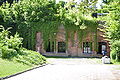
Fort "Siergieja"

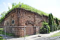
Fort "Aleksieja"

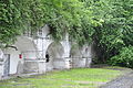
Fort "Włodzimierz"

Fort "Śliwickiego"


The forts of the inner defense ring
from north (over west) to south:
- Fort Burakov
- Fort P (also called Fort “Bema” or Fort “Parysów”). A small part of the fort has been preserved. The entire site is now designed as a recreational area for the Warsaw district of Bemowo .
- Fort W (also called Fort "Wola"). The fort no longer exists; in its place is the modern shopping center Fort Wola in Wola , which is based on the fort .
- Fort W-Tscha (also called Fort "Odolany"). A defunct auxiliary fort that was located in what is now the Odolany railway area in the Wola district.
- Fort Tscha (also called Fort "Szczęśliwice"). The fort is located on today's Jerusalemer Allee (Polish: Aleja Jerozolimskie). The interior is not used; Military buildings presumably built there after the Second World War have been demolished, with remains of rubble lying around. Outside there are extensive allotment gardens around the water-filled moat.

Fort P

Fort W

Fort Tscha


- Fort Tscha-M (also called Fort “Rakowiec”). The fort no longer exists; however, its soil structures are recognizable in a park laid out on it.
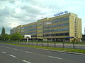
- Fort M (also called Fort “Mokotów”). The fort is on Racławicka Street. In addition to traders, it is now used by a restaurant and a café.
- Fort M-Chee (also called Fort “Odyńca”). The system no longer exists.
- Fort Che (also called Fort "Piłsudskiego" or Fort "Legionów Dąbrowskiego"). The fort belongs to the Polish army and is not used.

Fort Tscha-M
Fort M

Fort Che


The forts of the outer defensive ring
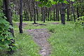
- Fort I (also called Fort "Bielany"). The fort was located in what is now a wooded area between Wybrzeże Gdyńskie Street and Marymoncka Street. The location of the former trench and the infantry and artillery walls can be seen from the bumps in the terrain. There are hardly any masonry parts of the fort left.
- Fort II (also called Fort "Wawrzyszew"). The fort belongs to the Bielany district and is located on the “Chomiczówka” housing estate near a local sports airport. The Polish army sold the plant. Today there is a riding school and allotments here.
- Fort IIA (also called Fort "Babice" and Fort "Radiowo"). The fort is located in Bemowo near the "Boernerowo" housing estate. It is still in the possession of the Polish army and is relatively well preserved. The moat is no longer completely available.
- Fort III (also called Fort "Blizne"). The facility is located near the “Groty” and “Górce” housing estates in the Bemowo district. Casemates and the main wall still exist . Head and shoulder capons were blown up.

Fort I

Fort II
Fort IIA

Fort III


- Fort IV (also called Fort “Chrzanów”). The fort is in Bemowo; remaining parts have expired.
- Fort V (also called Fort "Włochy"). The fort is located in today's Włochy district ; cemeteries have emerged in its outer area. Some of the casemates are well preserved. The entire facility is currently being expanded into a local recreation area.
- Fort VI (also called Fort "Okęcie"). This facility is also located in the Włochy district, in the immediate vicinity of Warsaw's Frédéric Chopin Airport . Here, too, allotments and a cemetery were created in the outer areas. On March 14, 1980, a Polish LOT machine crashed into the trench of the fort while approaching .
- Fort VII (also called Fort “Zbarż”). The fort, whose casemates are now under water, is currently unused. Allotment gardens were created outside. The construction of a new expressway, which will pass by from 2011, uncovered the foundations of the masonry.

Fort IV

Fort V

Fort VI

Fort VII


- Fort VIIA (also called Fort “Służewiec”). The fort is located between the avenue of the aviators (Polish: "Al. Lotników") and Puławska Street and is now used commercially. In addition to the historical buildings of the fort, office and warehouse buildings were built especially after the Second World War.
- Fort VIII (also called Fort “Służew”). The fort is now part of the Ursynów district and is located near the Warsaw University of Science . This fort is also surrounded by allotment gardens; Former camp casemates were used as garages by residents until 2009. An American real estate developer is planning to build a residential complex inside the listed fort.
- Fort IX (also called Fort "Czerniaków"). The fort is located in the Sadyba residential area of Warsaw's Mokotów district and currently houses the Museum of Polish Military Technology and the Katyń Museum .
- Fort X (also called Fort “Augustówka”). The fort is located in the largely undeveloped urban area of Siekierki in the immediate vicinity of the “Matki Bozej Naczycicielky Modziezy” sanctuary . The fort consisted of earth walls and is now used as a private shooting range.
Fort VIIA

Fort VIII
Fort IX

Fort X


- Fort XI (also called Fort “Grochów”). The fort no longer exists.
- Fort XIA (also called Fort “Grochów II”). The fort no longer exists.
- Fort XII (also called Fort “Antoninów”). The fort no longer exists; Bumps in a forest there today still reveal the structure of the facility.
- Fort XIIA (also called Fort “Lewinów”). The plant was located in Zacisze on today's Łodygowa Street. It was destroyed and today there are allotments here.
- Fort XIII (also called Fort "Lewicpol"). The fort was located in the place of today's “Bródno” forest park in the Warsaw residential area of the same name.
- Fort XIV (also called Fort "Marywil"). The fort no longer exists.
- Fort XIVA (also called Fort "Pelcowizna"). The fort no longer exists.
Fort XI

Fort XII


The forts attached to the fortress of Greater Warsaw
Two of the four (out of the planned seven) forts of the defense lines between the fortresses Warsaw, Modlin and Zegrze were attached to the Warsaw fortress:
- Away "Wawer" . The fort was demolished and a tree-lined park was created on its site.
- Fort "Kawęczyn". The connecting fort to the fortress Zegrze, also in the east, was demolished after the First World War .
Only bumps in today's park “Las Matki Mojej” are evidence of the former fort “Wawer”.

References and comments
- ↑ www.ww2awards.com
- ^ Georg Tessin : Associations and troops of the German Wehrmacht and Waffen-SS in World War II 1939–1945. Volume 4. The Land Forces 15–30 . 2nd Edition. Biblio-Verlag, Osnabrück 1976, ISBN 3-7648-1083-1 , p. 88-90 .
- ↑ The name "Nadbrzeżna" refers to the Polish description "Nad brzegiem" (German: "Over the bank") and indicates the high position of the positions with a field of fire over the Vistula.
- ↑ Józef Hauke-Bosak (1834-1871) was a Polish general and participant in the January uprising.
- ↑ named after Ludwik Mierosławski .
- ^ After Romuald Traugutt .
- ↑ referring to the Polish Legions .
Web links
- Map of the fortifications according to Ostrowski with a detailed history (in Polish)

Fortresses from the 19th century in Warsaw, Modlin and Zegrze
("Polish Fortress Triangle")
Fortress Modlin :
Citadel
Fort of the inner defense ring:
I |
II |
III |
IV |
V |
VI |
VII |
VIII
Fort of the outer defensive ring:
IX |
D-1 |
D-2 |
X |
D-3 |
XI |
D-4 |
XII |
XIII |
D-5 |
D-6 |
Fort group “Goławice” ( XIVb ) |
XIV |
Fort group “Carski Dar” (XV)
XVI |
D-7 |
D-8 |
Fort group "Janówek" ( D-9 , XVII ) |
D-10 |
XVIII
Warsaw Fortress :
Citadel Citadel
forts:
Nadbrzeżna Battery |
Fort Siergieja |
Fort Gieorgija |
Fort Pawła |
Fort Aleksieja |
Fort Władimira |
Fort Śliwickiego
Fort of the inner defense ring:
P |
W |
W-Tscha |
Tscha |
Tscha-M |
M |
M-Chee |
Che
forts of the outer defensive ring:
I |
II |
IIA |
III |
IV |
V |
VI |
VII |
VIIA |
VIII |
IX |
X |
XI |
XIA |
XII |
XIIA |
XIII |
XIV |
XIVA
Zegrze Fortress :
Great Festivals |
Small celebrations
Other forts:
Fort Beniaminów |
Fort Dębe |
Fort Kawęczyn |
Fort Łomianki |
Fort Maciołki |
Fort Pustelniki |
Fort Wawer
Coordinates: 52 ° 16 ' N , 21 ° 0' E