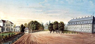
Friederikenplatz
The Friederikenplatz is a former square and today's traffic junction in Hanover , which was called Mühlenplatz since the Middle Ages because of the water mills there on the Leine . King Ernst August had the square renamed from Mühlenplatz to Friederikenplatz in 1843 because of the neighboring Friederikenenschlösschen and in honor of his late wife Friederike .
location
The traffic junction Friederikenplatz is located in the southern city center outside of the historic old town of Hanover. The streets Lavesallee, Friedrichswall , Karmarschstraße, Culemannstraße and Leibnizufer lead towards him. The street layout runs partly as a Friederiken bridge over the Leine. The Lower Saxony state parliament is in the immediate vicinity .
history

The original Mühlenplatz as the forerunner of the Friederikenplatz lay on an Otten werder between two branches of the river Leine. Its name was based on the local water mills, which were the click mill, first mentioned in 1226, and the Brückmühle, first mentioned in 1329 . When construction of the Leineschloss began in 1636 at the instigation of Duke Georg von Braunschweig and Lüneburg-Calenberg , the Mühlenplatz became the forecourt. 42 residential buildings were demolished on the Werder to provide a clear view from the castle.
After the city fortifications of Hanover had been razed at the end of the 18th century, a palace was built on the river Werder with Mühlenplatz in 1803 , which the master builder Georg Ludwig Friedrich Laves completed in 1817 for Count Carl von Alten . In 1841 King Ernst August bought the palace for his wife Friederike. That is why it was given the name Friederikenschlösschen. Two years after Queen Friederike's death, in 1843 the previous Mühlenplatz was renamed Friederikenplatz in her honor.
In 1895 the city of Hanover had the click mill on Friederikenplatz and the water art that had existed there for centuries demolished. Instead, the castle-like river water art was built, among other things to create a representative southern entrance to the city.

After the Second World War , Friederikenplatz was redesigned as a public traffic area, whereby all elements of a square were lost. After an arm of the river was filled in in 1955, the square became a traffic circle.
As a result of the redesign to an intersection in 1966, the former square next to Friedrichswall and Leibnizufer has since been used to guide traffic around the city center through the Cityring. In 1963 the river water art near the square and in 1966 the little Friederikenschlösschen were demolished.
In the course of the urban planning redesign project Hannover City 2020 + , a larger new building is planned at Friederikenplatz instead of the former Friederikenenschlösschen.
literature
- Franz Rudolf Zankl : Friederikenufer with the river side of the Leineschloss. Colored lithograph by Wilhelm Kretschmer . Around 1858 , in the latter. (Ed.): Hanover Archive , sheet S 25
- Eva Benz-Rababah : Friederikenplatz In: Klaus Mlynek, Waldemar R. Röhrbein (eds.) U. a .: City Lexicon Hanover . From the beginning to the present. Schlütersche, Hannover 2009, ISBN 978-3-89993-662-9 , p. 192.
- Helmut Knocke , Hugo Thielen : Friederikenplatz. In: Hannover Art and Culture Lexicon , p. 111
- Friedrich Lindau : Hanover. Reconstruction and destruction. The city in dealing with its architectural identity. Schlütersche, Hannover 2001 (2nd edition), ISBN 3-87706-607-0 .
Web links
Coordinates: 52 ° 22 '9.6 " N , 9 ° 43' 58.9" E

