Gain fern
|
Gainfarn ( district ) locality cadastral community Gainfarn |
||
|---|---|---|
|
|
||
| Basic data | ||
| Pole. District , state | Baden (BA), Lower Austria | |
| Judicial district | to bathe | |
| Pole. local community | Bad Vöslau | |
| Coordinates | 47 ° 57 '48 " N , 16 ° 12' 1" E | |
| Residents of the village | 3901 (January 1, 2020) | |
| Area d. KG | 23.39 km² | |
| Statistical identification | ||
| Locality code | 03377 | |
| Cadastral parish number | 04005 | |
| Counting district / district | Gainfarn (30603 01) | |
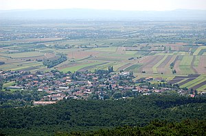
 Gain fern seen from the Harzberg |
||
| Source: STAT : index of places ; BEV : GEONAM ; NÖGIS | ||
Gainfarn is a district and a cadastral municipality in the municipality of Bad Vöslau , Lower Austria .
Gainfarn is directly connected to the southwest of Bad Vöslau and is served by Bad Vöslauer Straße (B 212) . In addition to Gainfarn, the cadastral community consists of the hamlet Haidlhof and some individual layers, including Merkenstein Castle .
In the Franziszeischen cadastre from 1819 the street village laid out in the form of a triangle is already registered with numerous smaller and bigger farmsteads.
Culture and sights
literature
- List of places 2001 Lower Austria , Statistics Austria, Vienna 2005, PDF , mentioned on page 65
Web links
Commons : Gainfarn - Collection of images, videos and audio files
Individual evidence
- ^ Franziszeischer Cadastre (around 1820): Gainfahrn ( online on mapire.eu ).

