Großau (Bad Vöslau municipality)
|
Großau ( village ) locality cadastral community Großau |
||
|---|---|---|
|
|
||
| Basic data | ||
| Pole. District , state | Baden (BA), Lower Austria | |
| Judicial district | to bathe | |
| Pole. local community | Bad Vöslau | |
| Coordinates | 47 ° 57 '21 " N , 16 ° 10' 3" E | |
| height | 310 m above sea level A. | |
| Residents of the village | 537 (January 1, 2020) | |
| Area d. KG | 7.1 km² | |
| Statistical identification | ||
| Locality code | 03378 | |
| Cadastral parish number | 04009 | |
| Counting district / district | Grossau (30603 020) | |
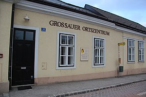
 Großau town center |
||
| Source: STAT : index of places ; BEV : GEONAM ; NÖGIS | ||
Großau is a village and a cadastral community in the municipality of Bad Vöslau , Lower Austria .
The village of Großau is located west of Gainfarn and can be reached via Bad Vöslauer Straße (B 212) . The street village with several farmsteads is recorded in the Franziszeischen cadastre from 1819. In addition to agriculture, viticulture and cattle breeding, the extraction and trade of pitch and turpentine also acquired a certain importance. The Haidlhof is also part of the village .
literature
- List of places 2001 Lower Austria , Statistics Austria, Vienna 2005, PDF , mentioned on page 65
Web links
Commons : Großau - collection of images, videos and audio files
Individual evidence
- ^ Franziszeischer Cadastre (around 1820): Großau ( online at mapire.eu ).
- ^ Wenzel Carl Wolfgang Blumenbach : Latest regional studies of Austria under the Ens , Volume 2, Verlag Carl Reichard, Güns 1835. p. 275

