
Ghardaia
|
غرداية(Ġardāya) ⵜⴰⵖⵔⴷⴰⵢⵜ (Taɣerdayt) Ghardaia |
|||
|---|---|---|---|
|
|||
| Coordinates | 32 ° 29 ′ N , 3 ° 40 ′ E | ||
| Basic data | |||
| Country | Algeria | ||
| Ghardaia | |||
| ISO 3166-2 | DZ-47 | ||
| height | 526 m | ||
| Residents | 93,423 (2008) | ||
| founding | 11th century | ||
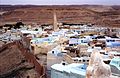
 View of Ghardaia / Bounoura (February 1990)
|
|||


Ghardaia ( Arabic غرداية Ghardaya , DMG Ġardāya , tamazight ⵜⴰⵖⵔⴷⴰⵢⵜ Taɣerdayt ; also Ghardaïa ) is an oasis city in Algeria and the capital and administrative center of the province of the same name (Wilāya Ġardāya). The city is located in the M'zab in the northern Central Sahara at an altitude of 526 m, belongs to the municipality of Ghardaia and, together with the southeastern cities of Beni Isguen , Melika , Bou Noura (Has Bunur) and El Atteuf (Tadjnint), forms the Pentapolis of the M ' zab.
Together with the other oases of the M'Zab Valley , Ghardaïa has been on the list of UNESCO World Heritage Sites since 1982 because of its exemplary urban development .
Origin of name
The name Ghardaïa comes from a saint named Daïa who lived in a cave (ghār) in the area. Later, Kharijite Muslims fleeing persecution by Orthodox Muslims in the north built a city there.
history
The main town of the Mzab Valley was founded by Kharijite Muslims in the 11th century and has remained largely unchanged since then. Ghardaia is a fortified city made up of three walled sectors with labyrinthine alleys. In the center is the historical Mozabite area with a pyramid-style mosque and a main and market square lined with arcades. The distinctive white, pink and red houses with their terraces and arcades are made of sand, clay and plaster and constructed with inner courtyards in such a way that sunlight can flood into all rooms. In her 1963 book “La force des choses”, Simone de Beauvoir described Ghardaia as a beautifully constructed cubist painting .
Geography and climate
The hill towns of the Pentapolis are located in northern central Algeria in the Sahara desert , along the west bank of the normally dry Wadi Mzab . The municipality of Ghardaia covers an area of 590 km², to which in addition to the Pentapolis the ancient Ksar of Metlili- Chaamba (42 km southwest) and outside the Mzab valley Berriane (Has Ibergane, 45 km north) and Guerrara (Iguerraren, 110 km northeast) belong.
The region's climate is characterized by strong day and night as well as summer and winter temperature fluctuations between 0 ° C and 46 ° C. The summer winds are hot and strong while the winter winds are cold and humid. Sandstorms usually occur from March to May. In October 2008, Ghardaia was hit by a flood caused by heavy rain.
|
Average monthly temperatures for Ghardaia
Source: missing
|
||||||||||||||||||||||||||||||||||||||||||||||||||||||||||||||||||||||||||||||||||||||||||||||||||||||||||||||||||||||||||||||||||||||||||||||||||||||||||||||||||||||||||||||||||||||||
population
The community has 104,645 inhabitants and the Pentapolis 82,500 (2005). The population is largely made up of Mozabites who speak their own Berber language, Mzab-Wargla. An important aspect of social life and the values of the people in the region is that there is no begging or theft. The Mozabites have close relationships with the community that governs all economic and social affairs. Everyone has the birthright that the community provides them with education, work, marriage and a home. The community organizes volunteer groups (Touiza) to build houses.
Water supply
The thousand-year-old water supply system was built by the Mozabites taking advantage of the rare water resources in the rivers (oueds). Because of the scarcity of this natural resource, the Mozabites developed a unique irrigation system with tunnels to collect rainwater and divert it to the oases. It allows a fair water distribution to all gardens and at the same time offers good flood protection. The water supply is ensured by a sophisticated irrigation system with many wells. The well bores are between 110 and 150 m deep and are fed by the continental groundwater basin of the Albium strata.
economy
Ghardaia is a center of the date (60,000 palm trees), carpet and cloth production and an important Algerian trade center with its own airport. In the south of the city, oil and natural gas are produced. It has bilingual vocational schools with French as a compulsory subject, a glass factory and a steel pipe factory.
Noumérat International Airport - Moufdi Zakaria is located about 18 km southeast of the city.
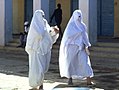
Ghardaia - Mozabite women in traditional cloaks that only leave one eye free to see
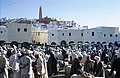
Market on the main square (1970)
Light-flooded courtyards in Beni Isguen, the holy city of the Mozabites

Ghardaia - Market Square on the Old Town Hill (1986)


Web links
- Ghardaia from "African Picture Book" (from Algiers to Agadez)
- Entry in the UNESCO World Heritage List (English) (French)
Individual evidence
- ↑ Population figures 2008. (English) ( Memento of the original from June 27, 2011 in the Internet Archive ) Info: The archive link was inserted automatically and has not yet been checked. Please check the original and archive link according to the instructions and then remove this notice.

