
Rossberg (Central Swiss Pre-Alps)
| Gnipen | ||
|---|---|---|
 Abort point on Rossberg (2004) |
||
| height | 1580 m above sea level M. | |
| location | Kantonsgrenze Canton Schwyz / Canton train , Switzerland | |
| Mountains | Schwyz Alps | |
| Dominance | 7.23 km → Rigi | |
| Notch height | 830 m ↓ Schornen | |
| Coordinates | 685 346 / 215066 | |
|
||
.jpg) Abort point from above |
||

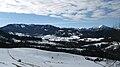
The Rossberg is a mountain range in the cantons of Schwyz and Zug in Switzerland . It has three summit points, the highest point is the middle summit point, the Wildspitz (1580 m), in the east the largely wooded Chaiserstock (1426 m), and in the west the bald Gnipen (1567 m). In between there are some secondary peaks, but the notch height is generally not great.
Geology and landslides
The Rossberg is made up of layers of the lower freshwater molasses, which tend to be unstable after heavy rain . Various landslides fell on the Rossberg in historical and prehistoric times . The best known is the Goldau landslide from 1806, which broke off below the Gnipen and almost completely destroyed the villages of Goldau and Röthen.
In the demolition niche of the Goldau landslide you get a remarkable insight into the stratification of the lower freshwater molasse with its characteristic sequence of Nagelfluh , sandstone and marl . A unique series of various forest development stages can also be observed on the Rossberg, which has developed on the block rubble area since the fall of the Goldau landslide.
The main ridge is also the canton border between the canton of Zug and the canton of Schwyz .
The north of the mountain range is drained via the Hüribach and its tributaries towards the Ägerisee . Most of the watercourses on the southern flank flow to Lake Lauerz and thus to Lake Lucerne via the Muota , while the extreme west of the Rossberg is drained into Lake Zug .
seen from the north: Rossberg whole left half of the picture (right Rigi)

Rossberg seen from the Mythen from the southeast, Goldau in the fog on the left, Aegerisee on the right

historical aerial photo by Werner Friedli from 1956
_von_Norden.jpg)
.jpg)
Individual evidence
- ↑ a b c Swisstopo ; 50,000 card Rotkreuz 235T edition 2003
- ↑ On the map edition 1991, and earlier, the altitude is 1568 m
Web links
- Wildspitz on GeoFinder.ch
- Gnipen on GeoFinder.ch
- Tour reports and photos Rossberg-Wildspitz and Rossberg-Gnipen