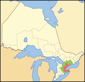
Golden Horseshoe
Golden Horseshoe (Golden Horseshoe) is a densely populated and industrialized region or metropolitan area around the western end of Lake Ontario in the Canadian province of Ontario . Large parts are also part of the Québec-Windsor Corridor . The population of around 8.1 million corresponds to about 25% of the population of Canada and 65% of the population of Ontario, making the Golden Horseshoe one of the most densely populated regions in North America . The inner and most densely populated area of the Golden Horseshoe forms the Greater Toronto Area .
The region extends from Niagara Falls at the eastern end of the Niagara Peninsula west to Hamilton and then northeast via Toronto to Oshawa . To the west the region extends to Kitchener and Waterloo , to the north to Barrie . The area of the Golden Horseshoe is around 33,500 km². 7,300 km² of this belong to a green belt in the hills of the Niagara strata and the Oak Ridges moraine .
The term "Golden Horseshoe" first appeared in a speech given by Herbert H. Rogge, Chairman of Westinghouse , on January 12, 1954, to the Hamilton Chamber of Commerce. This term was subsequently used as a geographical name. But it was not given quasi-official status until 2004 when the Ontario Ministry of Infrastructure Renewal published a growth report. It refers to the “Greater Golden Horseshoe” (GGH), which includes several neighboring districts in addition to the immediate riverside area.
Major cities in the Greater Golden Horseshoe
- Brampton
- Burlington
- Cambridge
- Guelph
- Hamilton
- Kitchener
- London
- Markham
- Mississauga
- Oakville
- Oshawa
- St. Catharines
- Toronto
- Waterloo
Individual evidence
- ↑ Representation of the population concentration - Statistics Canada
- ↑ Fast Facts from Hamilton's Past ( Memento of the original from September 5, 2006 in the Internet Archive ) Info: The archive link was inserted automatically and has not yet been checked. Please check the original and archive link according to the instructions and then remove this notice. - Hamilton Public Library
- ^ Places to Grow - Ministry of Public Infrastructure Renewal
Coordinates: 43 ° 30 ′ N , 79 ° 54 ′ W
