Quebec-Windsor Corridor
The Québec-Windsor Corridor (English Quebec City-Windsor Corridor , French Corridor Québec-Windsor ) in the provinces of Québec and Ontario is the most densely populated and most industrialized region of Canada . Over 17 million people live here (2001), which corresponds to around 57 percent of the population. In addition, six of the ten largest metropolitan regions in the country are located here . The corridor is around 1100 km long and 100 km wide. Its name is derived from the cities of Québec and Windsor , which are at either end of the corridor.
geography
The corridor stretches from Québec along the Saint Lawrence River , Lake Ontario and Lake Erie to Windsor , right next to Detroit . Major urban centers along the corridor are (from northeast to southwest) Québec, Trois-Rivières , Drummondville , Montreal , Cornwall , Brockville , Kingston , Belleville , Oshawa , Toronto , Hamilton , Kitchener , Waterloo , London , Chatham-Kent and Windsor. Additionally, the nearby towns of Sherbrooke , Ottawa , Peterborough , Guelph , Brantford , St. Catharines , Niagara Falls , Fort Erie , Barrie and Sarnia are connected to the main corridor by roads and railways.
Cities in neighboring American regions such as Upstate New York and Southeast Michigan are not included in the corridor, but have many cultural, economic and political similarities with urban areas on the border (e.g. Golden Horseshoe and Windsor). If the Detroit metropolitan area were also included in the corridor, the population would be about seven million higher.
For most of its length, the corridor runs through a narrow agricultural strip between the Canadian Shield in the north and the Appalachians or the Great Lakes in the south. The change from the limestone floor of the corridor to the granite floor of the Canadian Shield is abrupt in many places. On the peninsula of southwestern Ontario between the Erie and Huron Lakes, the otherwise narrow corridor widens significantly. This also applies to the lower reaches of the Ottawa River and to the Estrie region east of Montreal.
Due to the influence of the Great Lakes and the warm, humid air flowing in from the Gulf of Mexico , the climate in the corridor - especially in the western half - is significantly milder than in the rest of central Canada. The nutrient-rich soil and warmer climate ensure that the corridor's flora and fauna are similar to the deciduous forests of the eastern US states (as far as Virginia ), rather than the coniferous forests that cover most of central Canada to the polar regions .
history
During the French colonization of what would later become Canada in the 17th and early 18th centuries, only the eastern third between the cities of Québec and Montreal was more densely populated. The most important overland route of the Coureurs des bois , active in the fur trade , ran from Montreal through the Ottawa Valley and on via Lake Nipissing to Georgian Bay , that is, far north of the part of today's corridor in Ontario. The lack of good arable land made this route unattractive for settlements and numerous portages hindered inland navigation.
When the English-speaking loyalists came to Canada during and after the American Revolutionary War , they mainly settled in the narrow strip of land north of the Saint Lawrence River and Lake Ontario and Lake Erie. There was good arable land there and larger barges could be used. The Loyalists formed the core of the English-speaking population of Ontario. In contrast, many places along the northern corridor still have a significant French-speaking minority ( Franco-Ontarians ). At the beginning was Kingston , the main town in the English half of the corridor, but was then of Toronto surpassed.
Both during the French and Indian War between Great Britain and France and during the British-American War with the USA , the settlements along the corridor were at the center of the conflict. Ottawa was later declared the capital because it was further away from the Great Lakes and therefore less vulnerable to attack (although this city is now also counted as part of the corridor).
traffic
shipping
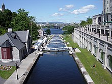
Inland shipping is the oldest mode of transport along the St. Lawrence River and the Great Lakes . The Rideau Canal connects Ottawa on the Ottawa River with Kingston on Lake Ontario . The 202 km long canal , opened in 1832, was built to create a traffic route that is not directly on the border. It should also serve as a supply route in the event of a renewed attack by the USA. Today it is only used for tourism; Since 2007 it belongs to the world heritage of UNESCO .
Numerous canals and locks form the St. Lawrence Seaway , a waterway developed between Lake Ontario and Montreal . The connection was established between 1951 and 1959. Its depth also allows ocean-going ships to sail over 3700 kilometers into the interior of Canada. The St. Lawrence River is one of the busiest inland waterways in the world, although it can only be navigated from April to December due to the thick layers of ice.
Streets
The first major main road in the Ontario part of the corridor is Highway 2 (known locally as Montreal Road , Toronto Road, or Kingston Road ). It follows the course of the stagecoach routes and the even older paths and paths. Highway 2 is still the main road in many cities along the corridor today as it was built around it. However, longer sections are no longer maintained by the province, but by counties and municipalities.
Between 1938 and 1968 the province built the parallel Highway 401 , a highway that bypasses most of the city centers. Highway 401 is one of the busiest roads in the world and leads to the Québec border. There it turns into Autoroute 20 , which leads through the Québec part of the corridor via Montreal and the city of Québec to the Gaspésie Peninsula.
railroad
Both the Canadian National Railway (CN) and the Canadian Pacific Railway (CP) operate intensive rail freight traffic along the Québec-Windsor corridor . The corridor is also the most important route for VIA Rail's passenger transport , with the majority of trains running on CN routes. VIA Rail generates around two thirds of its sales in the corridor. Amtrak offers international passenger services between Toronto or Montreal and New York City in parts of the corridor .
Local rail transport is offered in three agglomerations. GO Transit operates various suburban routes from Toronto; in the greater Montreal area, suburban trains run by the Agence métropolitaine de transport operate on several lines , and in Ottawa on a [obsolete] line of the O-Train .
aviation
The main airports along the corridor are Toronto Pearson International Airport , Aéroport international Pierre-Elliott-Trudeau de Montréal , Ottawa Macdonald-Cartier International Airport , Aéroport international Jean-Lesage de Québec and Hamilton / John C. Munro International Airport . There are around 60 flights a day between Montreal, Ottawa and Toronto alone, making this by far the most important air corridor in the country.
Web links
- Ecologically compatible traffic in the corridor (French)
- Traffic in Quebec City (English)
- Air pollution in the Quebec City-Windsor Corridor (English)


