Gorbitzbach
| Gorbitzbach | ||
|
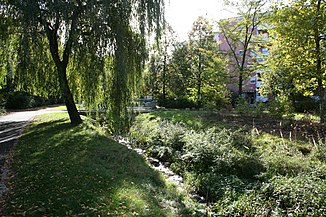
The Gorbitzbach in a renatured state, Am Gorbitzbach |
||
| Data | ||
| location | Dresden , Saxony , Germany | |
| River system | Elbe | |
| Drain over | Weidigtbach → Weißeritz → Elbe → North Sea | |
| source | on the northern edge of Lucknerpark in the district of Altfranken 51 ° 2 ′ 14 ″ N , 13 ° 38 ′ 50 ″ E |
|
| muzzle | In the Gorbitz district from the right in the Weidigtbach Coordinates: 51 ° 2 '53 " N , 13 ° 41' 5" E 51 ° 2 '53 " N , 13 ° 41' 5" E
|
|
| Catchment area | about 4 km² | |
The Gorbitzbach in the west of Dresden is the most important tributary of the Weidigtbach . It rises around one kilometer southeast of the old Weidigtbach spring, the Gompitzer village pond, on the northern edge of the Altfranken Park (also Lucknerpark ) in Old Franconia . At some distance it follows Kesselsdorfer Straße through the eponymous town of Gorbitz , cuts the far north of the Roßthal district , crosses Wölfnitz and flows into the Weidigtbach in the east of Gorbitz on Coventrystraße , which drains into the Elbe via the Weißeritz .
Like the Weidigtbach, the Gorbitzbach initially flows in an easterly direction, but then turns to the northeast towards the Weidigtbach. While the upper course with a stream floodplain in places with trees is still largely natural and has alluvial forest areas, the character of the stream changes when it enters the built-up area. It is predominantly built in its middle reaches and the land uses often extend to its banks, but it is inhabited by the gray wagtail . The trapezoidal brook profile in the lower course along Kesselsdorfer Straße was partially paved with grass pavers . A compensation for the construction of the federal motorway 17 resulted in an extensive renaturation of this section of the stream in 2008/2009.
An investigation of the water quality of the Gorbitzbach in 2001/2002 showed that the upper reaches are lightly polluted ( quality class I-II) and the lower reaches moderately polluted (quality class II).
Of the 8.5 km² catchment area of the Weidigtbach and its tributaries, around 0.9 km² are located outside Dresden in the Freital district of Pesterwitz , which is distributed over the Gorbitzbach and its right tributary, the Geyersgraben . As part of flood protection, there are two flood retention basins and three rainwater retention basins commissioned in 1962 on the Gorbitzbach , a fourth rainwater retention basin is located on Geyersgraben. The total volume of the six basins is around 34,000 m³ when they are fully flooded. Much more critical than long-lasting precipitation events such as the flood of the century in 2002 are very intense torrential rain lasting around 90 minutes. Due to the slope of the terrain and 20 rainwater discharge points, peak values are briefly achieved that significantly exceed the flow rate of bottlenecks, while flooding caused by floods of the century (HQ100) can be largely avoided.
The Gorbitzbach is (directly or indirectly) the namesake of several streets in Dresden (sorted by direction of flow):
- At the fountain in Gorbitz : The street shortly after the confluence of the Geyersgraben is probably named after a tube ridethat brought fountain water from the meadows on the Gorbitzbach to the Dresden Castle and the water features of the Zwinger .
- At the Stieglitzgrund in Wölfnitz : The eastern valley of the Gorbitzbach is known as the Stieglitzgrund. The street was laid out in 1925/26 during the construction of single-family semi-detached houses by two settlement companies and was given its name in January 1926.
- On the Gorbitzbach in Gorbitz : The road laid out in the Gorbitz prefabricated building area was named on March 15, 1979 after the neighboring stream.
Individual evidence
- ^ A b State capital Dresden, The Lord Mayoress, Environment Agency (ed.): Weidigtbach water profile . ( online ( memento of April 17, 2016 in the Internet Archive ) [PDF; 5.1 MB ] as of February 5, 2010).
- ↑ a b c d State capital Dresden, The Lord Mayor, Environment Office (ed.): Weidigtbach water profile . ( online [PDF; 3.7 MB ] as of July 6, 2012).
- ↑ a b Karlheinz Kregelin: The book of names of streets and squares in the west of the city of Dresden . Fly Head, 1996, p. 84 ( limited preview in Google Book search).
- ↑ Karlheinz Kregelin: The book of names of streets and squares in the west of the city of Dresden . Fly Head, 1996, p. 170 ( limited preview in Google Book search).
Web links
- Gorbitzbach in the Stadtwiki Dresden

