Grünhorn (Allgäu Alps)
| Grünhorn | ||
|---|---|---|
|
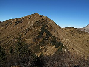
Grünhorn from the south |
||
| height | 2039 m above sea level A. | |
| location | Vorarlberg , Austria | |
| Mountains | Northwestern Walsertal Mountains , Allgäu Alps | |
| Dominance | 2.3 km → Üntschenspitze | |
| Notch height | 172 m ↓ Starzeljoch | |
| Coordinates | 47 ° 19 '25 " N , 10 ° 4' 46" E | |
|
|
||
| rock | Flysch | |
The Grünhorn is a 2039 m above sea level. A. high mountain in the Allgäu Alps in Vorarlberg .
Location and surroundings
The Grünhorn is part of the Baader mountain framing, which has a very rich flora due to the predominant flysch rock. The double-peaked Grasberg breaks off only to the northeast with steep walls and towers over the Steinmandl in the north and the Hochstarzel in the south .
The closest places are Baad in Kleinwalsertal in the southeast and Schoppernau in the southwest.
Ascent
- Over the eastern flank
From the Schwarzwasserhütte or from Baad to the Ochsenhofer Scharte, further over an insignificant elevation and the partly steep and somewhat slippery eastern flank to the spacious summit. 1.5 hours from Schwarzwasserhütte and 2.5 hours from Baad
- Over the south ridge
From the Starzeljoch over the wide, only briefly narrow south ridge to the summit. 3.5 hours from Schoppernau and 2.5 hours from Baad
- Over the north ridge
Marked from the Steinmandl on a wide ridge down to the lowest point, then over a few ridge towers (I) and an exposed but assured steep upswing to the pre-summit of the Grünhorn. From there it is easier to get into the depression and up to the main summit. Surefootedness and alpine experience required. 45 min. From Steinmandl
photos
Literature and map
- Dieter Seibert: Allgäu and Ammergauer Alpen Alpin, alpine club guide . Munich, Bergverlag Rudolf Rother, 17th edition 2008. ISBN 978-3-7633-1126-2 .
- Topographic map 1: 50,000 Allgäu Alps, Bavarian Land Survey Office, Munich. ISBN 978-3860380116 .


