Schoppernau
|
Schoppernau
|
||
|---|---|---|
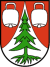
| coat of arms | Austria map | |
|
|
||
| Basic data | ||
| Country: | Austria | |
| State : | Vorarlberg | |
| Political District : | Bregenz | |
| License plate : | B. | |
| Surface: | 47.6 km² | |
| Coordinates : | 47 ° 19 ' N , 10 ° 1' E | |
| Height : | 852 m above sea level A. | |
| Residents : | 954 (January 1, 2020) | |
| Population density : | 20 inhabitants per km² | |
| Postal code : | 6886 | |
| Area code : | 05515 | |
| Community code : | 8 02 33 | |
| NUTS region | AT341 | |
| Address of the municipal administration: |
Unterdorf 2 6886 Schoppernau |
|
| Website: | ||
| politics | ||
| Mayor : | Walter Beer | |
|
Local council : (2015) (12 members) |
||
| Location of Schoppernau in the Bregenz district | ||
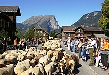
 View from the west of Schoppernau with the Üntschenspitze in the background |
||
| Source: Municipal data from Statistics Austria | ||
Schoppernau is an Austrian municipality in the state of Vorarlberg with 954 inhabitants (as of January 1, 2020). The municipality is located in the valley of the Bregenzer Ach in the rear Bregenzerwald and is known nationwide as a winter sports resort.
geography
Geographical location
The municipality of Schoppernau is a Bregenzerwald municipality and is located in the westernmost state of Austria, Vorarlberg, in the Bregenz district east of Lake Constance at an altitude of 852 meters. The village lies on the right bank of the Bregenz Ach as a long, row - like settlement. Below the elevated parish church, the settlement has been expanded into a heap village .
25.5% of the municipal area is forested, 36% are part of the Austrian Alps . Overall, the municipality, the populated part of which is largely located in the valley of the Bregenzer Ach, is characterized by the mountains of the Bregenzerwald and Lechquellen Mountains . There are no other cadastral communities in Schoppernau.
Districts
Districts of the community of Schoppernau are
|
|
|
Neighboring communities
Schoppernau shares a municipal boundary with five other Vorarlberg municipalities. These are the communities Au , Mittelberg and Schröcken as well as the market community Bezau in the Bregenz district and the community Sonntag in the Bludenz district . The community on the Diedamskopf barely borders on Bizau. The municipal boundaries of the two municipalities are sometimes only a few meters apart, separated by the municipality of Au.
climate
|
Average monthly temperatures and precipitation for Schoppernau
|
|||||||||||||||||||||||||||||||||||||||||||||||||||||||||||||||||||||||||||||||||||||||||||||||||||||||||||||||||||||||||||||||||||||||||||||||||||||||||||||||||||||||||
history
The community of Schoppernau appears in documents in the 15th to 17th centuries as "Schapernow" and "Schaupernaw". It belonged to the judicial district of Bregenzerwald and came to Austria with the rule of Feldkirch in 1390.
The Habsburgs ruled the places in Vorarlberg alternately from Tyrol and Upper Austria ( Freiburg im Breisgau ). From 1805 to 1814 the place belonged to Bavaria , then again to Austria. For Austrian province of Vorarlberg Schoppernau heard since its founding in 1861. The place was 1945-1955 part of the French zone of occupation in Austria.
For the history of the spa see Bad Hopfreben .
Population development

politics
The municipal council consists of twelve members, all of whom came from the Schoppernau citizens' list after the municipal council and mayoral elections in 2015 . The mayor of the community is Walter Beer from the Schoppernau citizens' list, who was confirmed in office in the direct mayor election 2015 with 84.69 percent of the votes.
Culture and sights
Churches and chapels
- Parish Church of St. Philip and James
- There was a chapel here around 1500. New buildings were built in 1610 and 1682 and the current church with tower was built in 1710. In 1796 it was redesigned by Josef Anton Natter and Josef Simon Moosbrugger. In 1956/1957 the church was enlarged again and an organ loft was built according to plans by Kaspar Albrecht . There are stucco decorations by Franz Michael Felder (1796) and figures by Christian Moosbrugger (1928). On the south wall of the choir is a memorial with a profile portrait of the poet Franz Michael Felder (1839–1869)
- Chapel of the poor souls
- built towards the end of the 19th century in the Himmelriese rebuilt in 2018
- Chapel of St. Mary
- in Graesalp
- Chapel of St. Mary
- Built in 1644 in Hinterhopfreben , this chapel was enlarged in 1912 according to a plan by Kaspar Felder.
- Chapel of St. Mary
- built in Schalzbach in 1981 according to plans by Kaspar Felder.
Municipal Office
This building was built in 1968/1969 by Jakob Albrecht and today houses the Franz Michael Felder Museum.
Other historical buildings
Personalities
- Franz Michael Felder (1839–1869), writer
- Christoph Lingg (* 1964), photographer
- Philipp Lingg (* 1984), singer of Holstuonarmusigbigbandclub (The name Schoppernau is included in the title of the song Vo Mello to ge Schoppornou )
- Herlinde Löhr (1927–2009), writer
- Alexander Moosbrugger (* 1972), composer
- Andreas Moosbrugger (1722–1787), Rococo plasterer
- Hieronymus Moosbrugger (1808–1858), stucco sculptor and artificial marble artist
- Peter Anton Moosbrugger (1732–1806), Rococo plasterer
- Walter Strolz (* 1927), editor and writer
- Anton Türtscher (* 1933), politician
- Franz Michel Willam (1894–1981), theologian and writer
Economy and Infrastructure
In 2003 there were 28 commercial businesses with 130 employees and 7 apprentices. There were 395 employees subject to wage tax .
Agriculture with milk processing (cheese dairy) and tourism are of great importance. In the 2001/2002 tourism year, the number of overnight stays was 192,383.
Together with the neighboring municipality of Au, Schoppernau forms the Au-Schoppernau Tourism Association.
Established businesses
The headquarters of Bergbahnen Diedamskopf , which was a company of the Silvretta Nova Group , which has been owned by BTV since 2007, is located in Schoppernau . Since 2009, the Diedamskopf mountain railways are 49% owned by Raiffeisen Bank Au and the communities of Au and Schoppernau, and 51% by the Warth lift company. They operate the two-section gondola lift (circulating cable car) to the Diedamskopf.
education
There is a primary school with (as of January 2003) 52 pupils and a kindergarten on site.
Web links
- 80233 - Schoppernau. Community data, Statistics Austria .
- Official website of the community of Schoppernau.
Individual evidence
- ↑ Statistics Austria - Population at the beginning of 2002–2020 by municipalities (area status 01/01/2020)
- ^ Vorarlberger Nachrichten : Poor Souls Chapel renewed by autumn. accessed on January 7, 2019


