
Üntschenspitze
| Üntschenspitze | ||
|---|---|---|
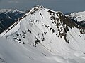
 From the west via Schoppernau with Heiterberg and Juppenspitze |
||
| height | 2135 m above sea level A. | |
| location | Vorarlberg , Austria | |
| Mountains | Northwestern Walsertal Mountains , Allgäu Alps | |
| Dominance | 3.3 km → Heiterberg | |
| Notch height | 281 m ↓ Üntschenpass | |
| Coordinates | 47 ° 18 '13 " N , 10 ° 3' 39" E | |
|
||
| Type | Steilgrasberg | |
| rock | Rhenodanubian flysch | |
| Age of the rock | chalk | |
| Normal way | From Bad Hopfreben over the Häfnerjoch | |

The Üntschenspitze (also Üntscheller , Vordere Üntschenspitze ) is a 2135 m high mountain near Schoppernau in the Austrian part of the Allgäu Alps . It is a steep grass mountain from Rhenodanubian flysch with flanks up to 1000 meters high. The summit is accessible with mountain hiking trails and is an insider tip for ski mountaineers in winter .
Origin of name
For the year 1818 a Uintscher Joch and a Hinter Uintscher Joch are mentioned for the first time in an Austrian military map . The current summit name was first mentioned in 1886: Uentscheller Sp. On an Austrian map. The origin of the name is not clear, but it refers to the alp name Üntschen . The origin of the word stem could be the presumably pre-German name Eunoschin , which was first used nearby in 1056.
Üntscheller is the local name of the mountain.
Location and surroundings
The Üntschenspitze is located in the district of Schoppernau in the Austrian state of Vorarlberg . The mountain rises to the east above the valley of the Bregenz Ach . This means that the mountain is steep and isolated over the Bregenzerwald . Its slopes are bordered from south to west by the Bregenzer Ach, in the north the Schrecksbach flows . Only to the north is the Üntschenspitze connected to the surrounding area via a mountain ridge . This ridge carries the Häfnerjoch (1979 m) and then moves to the southeast and finally ends at Baad . In the further course a branch branches off to Güntlespitze (2092 m) to the north. In the further course of the ridge, a southern branch branches off to the Heiterberg (2188 m), with the Üntschenpass (1854 m) in between. The latter two form the reference points for dominance and notch height .
geology
Geologically, the Üntschenspitze is made up of Rhenodanubian flysch , a sedimentary rock from the Cretaceous period . The deposits are up to 2000 meters thick. The main components are clays and marls . It is quickly weathered and impermeable to water. As a result, the water flows off relatively close to the surface of the soil and erodes a characteristic appearance of steep grass mountains with ravines .
Ascent
summer
The marked, sometimes steep normal route to the Üntschenspitze begins in the Schoppernau districts of Hinter Hopfreben (1007 m) or Vorder Hopfreben . From here a leading agricultural road past the Alpe Üntschenbergvorsäß (1,249 m) up to the Vorderüntschenalpe (1759 m). From here you continue on hiking trails to the Häfnerjoch (1979 m) and on to the summit. Alternatively, the Pisi-Alpe (1405 m) can be reached from Schoppernau (852 m) on the supply route . From there over the port hollow up to the Häfnerjoch. There are other ways to reach the Häfnerjoch from Baad (1220 m) over the Güntlespitze.
In addition, there are other, non-marked and slip resistance and vertigo requiring increases above West spur ( I degree ) by the northern flank (II.) And over the North spur (II.).
winter
The ski touring routes in winter are based on the paths in summer. The Üntschenspitze is an insider tip because of the interesting downhill options, for example via the Pisi-Alpe with a descent of more than 1300 meters .
photos

Summit cross

winter
From the Güntlespitze

Weathered rock


Web links
Individual evidence
- ^ Thaddäus Steiner : Allgäu mountain names . 2nd Edition. Kunstverlag Josef Fink, Lindenberg 2008, ISBN 978-3-89870-389-5 , pp. 210, 233.
- ^ Herbert Scholz: Building and Becoming the Allgäu Landscape . E. Schweizerbart'sche Verlagbuchhandlung (Nägele and Obermiller), Stuttgart 1995, ISBN 3-510-65165-0 , pp. 74ff.
- ↑ Dieter Seibert: Alpine Club Guide alpine - Allgäu Alps and Ammergau Alps . 17th edition. Bergverlag Rother , Munich 2008, ISBN 978-3-7633-1126-2 , pp. 177ff.
- ↑ Ernst Zettler, Heinz Groth: Alpine Club Guide - Allgäu Alps . 12th, completely revised edition. Bergverlag Rudolf Rother, Munich 1985, ISBN 3-7633-1111-4 , p. 506f.
- ↑ Kristian Rath: Allgäu ski tour guide with Kleinwalsertal and Tannheimer Tal . 6th edition. Panico Alpinverlag, Köngen 2009, ISBN 978-3-936740-10-3 , p. 48.
- ↑ Anton Kempf, Rainer Kempf: Bregenzerwald ski tour guide including the Great Walsertal and Lechquellen Mountains . 2nd Edition. Panico Alpinverlag, Köngen 2006, ISBN 3-936740-12-7 , p. 98.