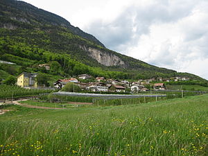
Graun (Kurtatsch)
| Graun | |||
|---|---|---|---|
| Italian name : Corona | |||

|
|||
| Graun | |||
| Country | Italy | ||
| region | Trentino-South Tyrol | ||
| province | South Tyrol (BZ) | ||
| local community | Kurtatsch | ||
| Coordinates | 46 ° 20 ′ N , 11 ° 13 ′ E | ||
| height | 800 m slm | ||
| Residents | 250 () | ||
| Demonym | Grauner | ||
| Telephone code | 0471 | CAP | 39040 |
Graun is a fraction of the municipality of Kurtatsch in South Tyrol . The village with about 250 inhabitants is located on the South Tyrolean Wine Road , about 1.5 kilometers north and 500 meters above the main town of Kurtatsch (5 kilometers by road). Graun is located on a terraced high plateau around 600 meters above the bottom of the Adige Valley . The Mendelkamm in the west reaches a height of almost 2000 m .
The place is rural, wine and fruit are grown.
Worth seeing
There are hardly any traces of the former Graun Castle on a hilltop southwest of today's village center. A little south of the village is the Gothic church of St. George, a protected cultural asset . Located in the actual place and also under monument protection is the parish sanctuary with the chapel of St. Simon and Juda. The core of the medieval building was rebuilt in the 17th century.
Web links
Individual evidence
- ↑ www.suedtirolerland.it: Information about Kurtatsch Berg , accessed on February 28, 2014.
- ^ Magdalena Hörmann-Weingartner: Graun . In: Magdalena Hörmann-Weingartner (ed.), Tiroler Burgenbuch. Volume X: Überetsch and South Tyrolean Unterland . Athesia publishing house, Bozen 2011, ISBN 978-88-8266-780-1 , pp. 315-316.
- ^ Autonomous Province of Bozen - South Tyrol, Department of Monument Preservation: Pfarrwidum

