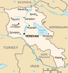
Border between Armenia and Turkey
The border between Armenia and Turkey is a land border of 311 kilometers in length. Armenia is a member of the Eastern Partnership , Turkey is a candidate for accession to the European Union . There are two border crossings, which Turkey has closed since 1993 due to the Nagorno-Karabakh conflict .
Residents (administrative units)
from north to south
Turkey
Armenia
course
The border runs roughly from north to south, beginning at the triangle Armenia-Georgia-Turkey, on the Aras and Achurjan to the triangle Armenia-Azerbaijan (Nakhichevan) -Turkey and is 311 kilometers long. This limit was set in the Treaty of Kars in 1922.
Border crossings
Major border crossings are:
- Armenia: Akhurik , Shirak ↔ Turkey: Akyaka , Akyaka District, Kars Province (closed)
- Armenia: Margara , Armavir ↔ Turkey: Karakoyunlu, Iğdır Province (closed)
Recent history
On October 13, 1921, the Treaty of Kars was adopted, which was ratified on September 11, 1922.
See also
Web links
Commons : International borders of Armenia - Collection of images, videos and audio files
Commons : International borders of Turkey - Collection of pictures, videos and audio files


