
Grimspound

Grimspound is an archaeological site in England and is located in Devon in Dartmoor National Park on a farm on Hookney Tor hill near the village of Widecombe-in-the-Moor .
etymology
The name Grim goes back to the Anglo-Saxons or Normans . He is a synonym for the Norse god Odin . See also Graemsay Island in Orkney , Grimsay Island in the Hebrides, Grimsby Place in Lincolnshire, Grimsbury Castle Hillfort in Oxfordshire , Grim's Ditch an earthwork , Grim's Dyke (name for the Antonine Wall), Grim's Grave stone chest (also kistvaen) in Dartmoor , Grimes Graves flint mines , Grimshader (Grims Seat) on Lewis and Harris, Grims Lake Mire (stone chest in Grims Lake Morass), Grim's Mound a round hill in Lincolnshire , Grimsetter (Grims Seat) on Orkney and Shetland, Grimsthorpe Castle (Grims village), as well as several places or Combinations with the name Grimston (e.g. Grimston-Lyles Hill Ware ). When the topographer Reverend Richard Polwhele named the square, he unspokenly created the context for a cult square, but called it a place of jurisdiction, i.e. Thingplatz.
- Grimspound

Grimspound from Hookney Tor Hill
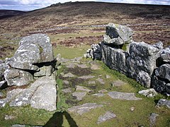
Access to Grimspound

Aerial view

A hut foundation


Grimspound comes from the Bronze Age , around 1300–1000 BC. Chr., And consists of a round area of about four hectares, which is bordered by a 2.8 m wide and 1.5 m high dry stone wall. It originally consisted of two walls set about one meter apart and together were about 3.5 m wide. Inside are the foundations of 24 round huts with a diameter of around 3.4 m. The wall is interrupted at one point by a well-preserved and paved passage. There is little evidence of human activity. The artifacts are made up of broken pottery and scrapers .
Everyone agrees that the wall was insufficient for military purposes. Since a stream runs through the area on the edge of the circle, the also unconfirmed idea of a cattle kraal was developed. There are around 20 such walls, known as Dartmoor Pounds .
See also
literature
- JW Brailsford: Bronze Age Stone Monuments of Dartmoor . Antiquity 12 (number 48), 1938, 454
- Homer Sykes: Mysterious Britain - Fact and Folklore George Weidenfeld & Nicolson Ltd. 1993 ISBN 0-297-83196-8 p. 57
Individual evidence
- ↑ Tor (rock formation) , English name for a rock formation; see showery gate
Web links
- Grimspound: A study of this ancient bronze age settlement on Dartmoor, South-West England
- Description Engl. and pictures
Coordinates: 50 ° 36 '47.9 " N , 3 ° 50' 14.6" W.