Târnava Mare
|
Târnava Mare Great Kokel Nagy-Küküllő |
||
|
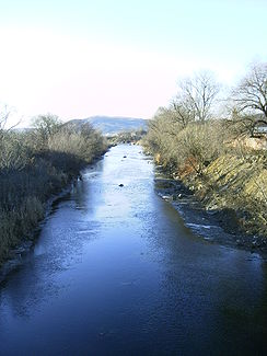
The great Kokel at Cristuru Secuiesc |
||
| Data | ||
| location | Transylvania ( Romania ) | |
| River system | Danube | |
| Drain over | Târnava → Mureș → Tisza → Danube → Black Sea | |
| source | near Vărșag ( Gurghiu Mountains ) | |
| Source height | 1455 m | |
| Union | at Blaj with the Târnava Mică to Târnava coordinates: 46 ° 10 ′ 15 ″ N , 23 ° 53 ′ 32 ″ E |
|
| Mouth height | 250 m | |
| Height difference | 1205 m | |
| Bottom slope | 5.4 ‰ | |
| length | 223 km (246 km with Târnava ) | |
| Catchment area | 3666 km² | |
| Drain |
MQ |
14.5 m³ / s |
| Left tributaries | Vișa | |
| Medium-sized cities | Odorheiu Secuiesc , Sighișoara , Mediaș | |
| Small towns | Cristuru Secuiesc , Blaj , Dumbrăveni , Copșa Mică | |
| Communities | Vărşag , Zetea , Feliceni , Mugeni , Șaroş pe Târnave , Brateiu , Micăsasa | |
|
The Târnava Mare in Romania |
||
The Târnava Mare (German the Great Kokel , formerly the Great Kokel , Hungarian Nagy-Küküllő ) is a (with the Târnava ) 246 km long tributary of the Mureș in Transylvania ( Romania ). It rises in the Gurghiu Mountains ( Eastern Carpathians ) at an altitude of 1455 m above sea level and unites at Blaj (bubble village) with the Târnava Mică (Little Kokel) to the Târnava (Kokel) .
Web links
Commons : Târnava Mare - collection of images, videos and audio files
Individual evidence
- ↑ a b Administraţia Bazinală de Mures APA. (PDF; 1.6 MB) Retrieved August 20, 2020 (Romanian).
- ↑ http://www.retrobibliothek.de/retrobib/seite.html?id=109515#Kokel

