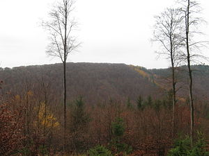
Great Teichtalskopf
| Great Teichtalskopf | ||
|---|---|---|
|
, Large Teichtalskopf from the steep wall seen from |
||
| height | 492 m above sea level NHN | |
| location | near Herzberg am Harz ; District of Göttingen , Lower Saxony ( Germany ) | |
| Mountains | Resin ( middle resin ) | |
| Dominance | 0.5 km → Hirtenberg and Langfast | |
| Coordinates | 51 ° 40 '36 " N , 10 ° 21' 49" E | |
|
|
||
The Great Teichtalskopf is about 492 m above sea level. NHN high mountain in the Harz . It is located near Herzberg am Harz in the non-parish Harz region of the Göttingen district in Lower Saxony .
geography
location
The Große Teichtalskopf rises in the Central Harz Mountains and in the Harz National Park . Its summit is just under 3 km north-northeast of the heart of the Herzberg town center. The mountain separates the Sieber valleys in the east and Lonau in the west. The landscape leads to the northeast with a low notch height to the Hirtenberg ( 582 m ), to the south-southwest it drops past the Kleiner Teichtalskopf ( 362 m ) to the confluence of the Lonau in the Sieber.
Natural allocation
The Große Teichtalskopf belongs to the natural spatial main unit group Harz (No. 38), in the main unit Upper Harz (380) and in the subunit Southern Upper Harz (380.8) to the natural area Sieberbergland (380.82). The landscape falls to the southwest into the natural area of gravel fields of the Rhume , Oder and Sieber (376.23), which belongs to the main unit group Weser-Leine-Bergland (37) and its main unit Southwest Harz foreland (376) to the subunit Osterode-Herzberger Vorland (376.2) .
Protected areas and forest cover
Parts of the fauna-flora-habitat area Harz National Park (Lower Saxony) (FFH No. 4129-302; 157.7 km² ) and the Harz National Park bird sanctuary (VSG No. 4229-402; 155, 59 km²). The Siebertal nature reserve ( CDDA no. 64701; designated 1992; 6.947 km²) and the FFH area Sieber, Oder, Rhume (FFH no. 4228-331; 24.5051 km²) extend to the eastern slope . The mountain is almost completely overgrown with beeches.
Pond valley
The short Teichtal lies south-southwest of the Großer Teichtalkopf . It runs in a predominantly southerly direction west past the Kleiner Teichtalskopf and flows into the Sieber valley east to south-southeast of the Kleiner Teichtalskopf .
source
- Topographic map Bad Lauterberg , No. 4328, M = 1: 25,000 (TK25), ISBN 9783894354237
References and comments
- ↑ Jürgen Spönemann: Geographical Land Survey: The natural spatial units on sheet 100 Halberstadt. Federal Institute for Regional Studies, Bad Godesberg 1970. → Online map (PDF; 4.7 MB)
- ↑ Map services of the Federal Agency for Nature Conservation ( information )
- ↑ Teichtal : this valley is not labeled on some topographic maps
- ↑ Hiking map of Lonau in the Harz Mountains and the immediate vicinity , scale 1: 25000, published by the Harz Club branch association Lonau, 1953 and 1959
- ↑ Klaus Gehmlich: Field names in the district of Osterode am Harz. Volume 1, Verlag Papierflieger, Clausthal-Zellerfeld 2008, ISBN 978-3-89720-971-8 , p. 219

