Great stone grave lie
| Great stone grave lie | ||
|---|---|---|
|
|
||
| Coordinates | 52 ° 46 ′ 28.5 " N , 11 ° 20 ′ 56.9" E | |
| place | Arendsee (Altmark) , Saxony-Anhalt , Germany | |
| Emergence | 3700 to 3350 BC Chr. | |
The large stone grave Läge is a megalithic grave complex of the Neolithic deep engraving ceramic culture near Lüge , a district of the city of Arendsee (Altmark) in Saxony-Anhalt .
location
The facility is located 1.7 km north of Liege on the border with Ladekath in a forest. To the north-west was the large stone grave Ladekath , which was destroyed in the 19th century .
Research history
When Johann Friedrich Danneil tried for the first time in 1843 to document all the megalithic graves in the Altmark, he overlooked the complex in Lie. It was only described by Eduard Krause and Otto Schoetensack when it was re-recorded in the early 1890s. In 2003-04, all remaining large stone graves in the Altmark were recorded and measured as a joint project of the State Office for Monument Preservation and Archeology of Saxony-Anhalt , the Johann Friedrich Danneil Museum in Salzwedel and the association “Young Archaeologists of the Altmark”.
description
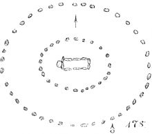
The grave belongs to the large dolmen type . The originally oval burial mound has been largely destroyed. Boulders suggest that he had a stone mantle. The border consisted of two oval stone settings (a rare shape that has otherwise been preserved in the Emsland), but had completely disappeared by the end of the 19th century. Eduard Krause and Otto Schoetensack were only able to reconstruct the form of the enclosure during their investigations in 1893 by asking the population.
The burial chamber is also largely destroyed. Krause and Schoetensack found all eight wall stones, the cap stones were already completely missing. The chamber was oriented east-west. It was rectangular, 3.7 m long, 1.2 m wide and 1.25 m high. There was also a menhir on the outer west side . Today there are only three stones left, which form a 3.9 m long, northeast-southwest oriented line.
See also
literature
- Hans-Jürgen Beier : The megalithic, submegalithic and pseudomegalithic buildings and the menhirs between the Baltic Sea and the Thuringian Forest (= contributions to the prehistory and early history of Central Europe. Volume 1). Wilkau-Haßlau 1991, p. 57.
- Hartmut Bock , Barbara Fritsch, Lothar Mittag: Great stone graves of the Altmark . State Office for Monument Preservation and Archeology Saxony-Anhalt and State Museum for Prehistory, Halle (Saale) 2006, ISBN 3-939414-03-4 , pp. 126–127
- Eduard Krause , Otto Schoetensack : The megalithic graves (stone chamber graves) of Germany . I .: Altmark . In: Journal of Ethnology . Vol. 25, 1893, p. 161 / no. 178, Plates VI / 178, VII / 178 ( PDF; 39.0 MB ).
Web links
- The Megalithic Portal: Liege Steingrab
- grosssteingraeber.de: The destroyed large stone grave lie near Salzwedel
- tw.strahl.org: Large stone grave " Läge ", Läge near Salzwedel, Altmark

