
Gudenhagen-Petersborn
|
Gudenhagen-Petersborn
City of Brilon
Coordinates: 51 ° 22 ′ 12 " N , 8 ° 34 ′ 38" E
|
|
|---|---|
| Height : | 415-580 m above sea level NN |
| Residents : | 1251 (Dec. 31, 2013) |
| Postal code : | 59929 |
| Area code : | 02961 |
  Location of the village of Gudenhagen-Petersborn within the urban area of Brilon
|
|
 Aerial photo (2013)
|
|
Gudenhagen-Petersborn is the youngest district of the city of Brilon in the eastern Sauerland ( North Rhine-Westphalia , Germany ). According to the city of Brilon, 1251 inhabitants lived in Gudenhagen-Petersborn on December 31, 2013.
location
Gudenhagen is located 2.7 km south-southeast of Brilon on the side of the B 251 , which leads to Willingen . The height is 470 m on the B 251 to 530 m on the slope of the Gudenhagener Poppenberg. The Gudenhagener Tunnel (280 m) is located at the Almetalbahn , but the stop is abandoned. Petersborn with an altitude of 510 to 580 m is located 3 km south of the core city and southwest of Gudenhagen. The watershed between the Rhine and the Weser runs through Petersborn .
In January 2007, hurricane Kyrill devastated large parts of the forest. To commemorate this, the Kyrill-Tor stands at the entrance to the village on an area that has been reforested .
history
Gudenhagen was first mentioned in a document in 1446 in the Soest town register. The place was probably part of the allodium of the brothers Conrad and Everhard von Gudenberg. The Gudenhagen estate later went to the noble lords of Hoppecke as a fiefdom , who lent the land to the church in Brilon. After 1600 the feudal right passed to the lords of Padberg. The estate was lent as an after-fief ; the fief-taker was free to lease the land to farming families, with a laudemium due.
Gudenhagen was ecclesiastically attached to the parish of Brilon, the deceased were buried in the municipal cemetery.
A chapel was built in the 1950s and the Catholic Church of St. Michael from 1968 to 1970 .
The Christians of the other denomination use the Evangelical Church in Gudenhagen .
Around 1616, the Gudenhagen manor district achieved a certain degree of independence. A special tax from the Duchy of Westphalia was expressly requested from Schulten in Gudenhagen. According to a protocol of a church visitation from 1708, Gudenhagen consisted of two courtyards at the time.
The district has always been part of the urban area of Brilon. The first residents were in the powder mill in the Hoppecketal and in the outskirts of Gudenhagen. The Petersborn settlement was founded in the mid-1950s and the development in Gudenhagen was concentrated around ten years later.

Kyrilltor in the Bürgerwald at the entrance to the village

Cyrillic head
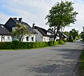
Street with former settlement houses in Petersborn
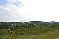
View over Petersborn


Web links
Individual evidence
- ↑ Population statistics December 31, 2013. (PDF) City of Brilon, accessed on January 18, 2014 (10.8 kB).
- ↑ Gerhard Brökel, Past Times, Ed. Geschichtsverein Semper Idem 2006, pp. 57 and 58
- ^ Gerhard Brökel , From the history of the Maria Hilf Brilon Hospital, Weyers Druck, Brilon, 1997, page 46
Alme | Altenbüren | Bontkirchen | Brilon | Brilon Forest | Esshoff | Gudenhagen-Petersborn | Hoppecke | Madfeld | Messinghausen | Nehden | Radlinghausen | Rixen | Rösenbeck | Scharfenberg | Thulen | Hurled