Ports of Kehl
| Ports of Kehl | |||
|---|---|---|---|
| Data | |||
| UN / LOCODE | DE KEH | ||
| operator | Kehl port administration | ||
| opening | Antiquity | ||
| Port type | Port and lands | ||
| Throughput | 4 million tons (2012) | ||
| website | http://www.hafen-kehl.de/wDeutsch/hafenverwaltung/index.php | ||
| Geographic information | |||
| place | Throat | ||
| country | Baden-Württemberg | ||
| Country | Germany | ||
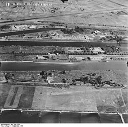
| Kehl harbor basin 1953 | |||
| Coordinates | 48 ° 35 '30 " N , 7 ° 48' 53" E | ||
|
|||
The ports of Kehl include three port basins for large shipping , a land for passenger shipping ( Stromhafen ), a sports boat port for recreational shipping and an industrial area.
They are between Rhine kilometers 293.3 and 297.3. The commercial port is located in the north of the city of Kehl , Baden-Württemberg at the confluence of the Rhine and Kinzig rivers on a peninsula southwest of the Auenheim district .
geography
The ports of Kehl are located on the right bank of the Rhine at three spatially separated locations west of the town center at an altitude of 137 m above sea level. NN .
- Rhine km 293.3 R: Kehl passenger shipping area (Stromhafen)
- Rhine km 293.8 R: Kehl marina, entrance
- Rhine km 297.3 R: Rheinhafen Kehl (commercial large shipping)
history
The Rhine was a strategically and economically important transport route as early as Roman times. There was rowing, sailing, stomping and trekking . At the turn of the century there was a Roman fleet on the Rhine , which was supplied with first-class timber for shipbuilding from the Black Forest via the Kinzing . After the fall of the Roman Empire, rafting was maintained through all times until the end of the 19th century.
The first protective harbor with a basin separated from the Rhine stream was built in Kehl in 1842. It already had a railway connection from 1844 and has been continuously expanded since then.
In World War II, the facilities were largely destroyed; In 1944 the area was evacuated.
The reconstruction took place in 1951/52; In 1953 the docks were rebuilt in their present form. (see aerial photo from 1953 above) In 2002 the port basin III was extended to a length of 600 m.
Commerce and infrastructure
Today the commercial port facilities cover a 320 hectare site with 12 km of quays . The rail connections of the port railway open up all landing stages and enable trimodal freight traffic. There is a heavy goods transshipment point with a quay length of 60 m, a width of 30 m and mobile crane systems as well as two container cranes with 42.5 t and 50 t load capacity at the container terminal . Three further loading bridges for bulk goods lift 22 to 25 t each. Industrial trucks , two mobile 26.5 t excavators, pumps for handling liquids, supply and disposal facilities are available. Various indoor and outdoor storage areas cover a total of almost 13 hectares. There are heavy-duty road connections to the European trunk road network. In 2011 around 3,500 motorized goods ships were unloaded or loaded. There are around 130 companies located in the port area, which employ almost 4,500 people. With an annual cargo turnover of four million tons, Kehl is the most efficient port on the Upper Rhine .
traffic
The Kehler ports are connected to the state road 75 and the federal road 28 . Track branches from Kehl train station connect the rail traffic with the Strasbourg - Karlsruhe line .

