Hüser (mountain)
| Husser | ||
|---|---|---|
|
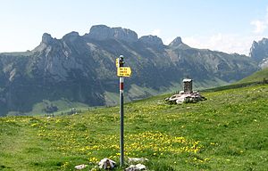
Furgglenfirst seen from the northeast from Alp Sigel ; Stauberen on the left, then the Hüser, Hochhus and Saxer Lücke as a conclusion, then the Chrüzberg -Wand follows. |
||
| height | 1951 m above sea level M. | |
| location |
Switzerland , ( Appenzell Innerrhoden , St. Gallen ) |
|
| Mountains | Appenzell Alps , Alpstein | |
| Dominance | 1.45 km → Saxer First | |
| Notch height | 302 m ↓ Saxer gap | |
| Coordinates | 752 038 / 235911 | |
|
|
||
| rock | limestone | |
Hüser is the name of a summit ridge or mountain range above the Furgglenfirst between the Saxer Lücke and the Staubernkanzel , which lies on the border of the Swiss cantons of St. Gallen and Appenzell Innerrhoden on the eastern edge of the Alpstein and reaches a maximum height of 1951 m . To the southwest of the Hüser stands the Hochhus summit on the same Furgglenfirst .
According to a strict definition, the Hüser are the main peaks of the entire mountain range from Kamor over the Hohe Kasten to the Saxer Lücke , which also means that the route is suitable as a high-altitude hike, as the maximum descent is only about 200 meters from the Hohe Kasten and the Hüser can even be hiked northwest from the Staubernkanzel. To the southwest lies the Saxer Lücke, after the Hochhus , where hikers often descend north to the Fälensee or south to Sax; this is far more strenuous, because the Hüser tower over the St. Gallen Rhine Valley by around 1,500 meters, from the Saxer Lücke it is still 1,200 meters in altitude.
Names on the national map
The points 1'914 on the south-western and 1'951 on the north-eastern group listed on the national map remain unnamed, the name Hüser is at point 1'914. In contrast, a prominent tower on the southern flank has earned the name tower and is listed on the national map at 1784 m .
Field names
Field names not shown on the national map designate the Üsseren Hüser as the most south-westerly group, then the Mittlere Hüser and Hinderen Hüser with the highest point at 1951 m , then the Hüsersattel (terrain sink above Alp Alpeel (Frümsen), between the Mittleren and Hinderen Hüser; on the Appenzell side is accessible via a wide, steep couloir). The Hinderen Hüser is followed by the Zanlugge (a striking gap in the rock above the Frühmsner Alp, between Hüsersattel and Staubernchanzle, in the Schafwand, above the Haselstögg. Hardly used today. Officially rewritten as: Zaalugge) in front of the Staubernchanzel .
Individual overview
Hüser (Hohe Hüser)
The ridge between Hochhus and Stauberenkanzel is marked with "Hüser" on the national map. It comprises three peaks with the old field names: Üssere Hüser 1914, Mittlere Hüser approx. 1936, Hintere Hüser 1951. The Hüsersattel is located between the Mittlere and Hinteren Hüsern.
Chirchli
On the Rhine valley side, the rock needle between the Üsseren and the Mittleren Hüsern is called Chirchli. The name is also on the map of the municipality of Frümsen with the official field names.
Furgglenzahn / Kirchli
The distinctive rock formation below the Staubern - Saxerlücke hiking trail is shown on the map without any altitude or field names. It is known as the Furgglenzahn or the Kirchli. The shape on its southwest side is strikingly like a church with a tower and nave. The name Kirchli is on the old Siegfried map (Topographical Atlas of Switzerland before 1926) exactly between this rock formation and the point 1914 on the houses.
Zaalugge
The distinctive cut between the high and the small houses is called Zaalugge. On the Rhine valley side, the rock face under the Zaalugge is called the sheep wall. The Furgglenfirst ends at the Zaalugge.
Small husks and pulpit
The mountain range ends in the northeast with the small pines overgrown with the Kleine Hüsern and the rock tower of the Stauberenkanzel. Both peaks belong to the Stauberenfirst.
credentials
literature
- Werner Küng: Alpstein climbing guide . SAC-Verlag, 2001


