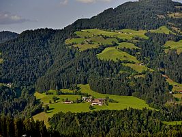
Hacha (municipality of Hopfgarten)
| Hacha ( village ) | ||
|---|---|---|
|
|
||
| Basic data | ||
| Pole. District , state | Kitzbühel , Tyrol | |
| Pole. local community | Hopfgarten im Brixental ( KG Hopfgarten Land) | |
| Locality | Salvenberg | |
| Coordinates | 47 ° 27 '36 " N , 12 ° 9' 23" E | |
| height | 760 m above sea level A. | |
| Post Code | 6361 Hopfgarten im Brixental | |
| prefix | + 43/05335 | |
| Statistical identification | ||
| Counting district / district | Salvenberg (70406 002) | |
 Look at Hacha |
||
| Source: STAT : index of places ; BEV : GEONAM ; TIRIS | ||
Hacha is a part of the municipality of Hopfgarten im Brixental in the Kitzbühel district . It is about 760 m above sea level. A. on the southwest side of the Hohe Salve on a plateau above Hopfgarten.
The development consists of the three historical homesteads Gugg, Third and Rauch, as well as six other private houses and a small local chapel. Hacha is characterized by agriculture (cattle breeding, milk production, eggs, cheese, fruit schnapps) and offers accommodation for holiday guests.
tourism
Hiking, jogging and mountain bike routes in the region lead directly through Hacha.
