Kõpu Peninsula
| Kõpu Peninsula | ||
| Geographical location | ||
|
|
||
| Coordinates | 58 ° 53 '47 " N , 22 ° 11' 48" E | |
| Waters 1 | Baltic Sea | |
 Kõpu lighthouse |
||
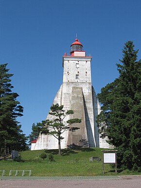
The Kõpu peninsula ( Estonian Kõpu poolsaar ) extends in the far west of the island Hiiumaa into the Baltic Sea . On the peninsula is the symbol of the second largest Estonian island, the mighty Kõpu lighthouse ( Kõpu tuletorn ).
description
The Kõpu Peninsula (historical German name "Peninsula Keppo") is about 21 kilometers long and up to 7.3 kilometers wide. At its western tip is the headland Ristna ( Ristna neem ) with its lighthouse ( Ristna tuletorn ).
The highest point on the peninsula is the 78 meter high Tornimägi ("Tower Mountain"). The coastline is characterized by high dunes and numerous boulders . The landscape is protected by three large (nature) protected areas.
About two hundred people live on the peninsula in the villages of Hirmuste , Jõesuu , Kalana , Kaleste , Kiduspe , Kõpu , Luidja and Mägipe . It belongs administratively to the rural community of Hiiumaa .
literature
- Thea Karin: Estonia. Cultural and scenic diversity in a historical borderland between east and west. Cologne 1994 (= DuMont art and landscape guide ) ISBN 3-7701-2614-9 , pp. 338-340
Web links
- Entry in Eesti Entsüklopeedia (online version)
Individual evidence
- ↑ Baltic historical local dictionary. Part 1: Estonia (including Northern Livonia). Started by Hans Feldmann . Published by Heinz von zur Mühlen . Edited by Gertrud Westermann . Böhlau, Cologne / Vienna 1985 (= sources and studies on Baltic history. Volume 8/1), ISBN 3-412-07183-8 , p. 377.
