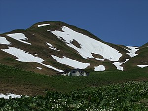
Haldenwanger head
| Haldenwanger head | ||
|---|---|---|
| height | 2002 m above sea level NN | |
| location | Border Bavaria , Germany / Vorarlberg , Austria | |
| Mountains | Southeastern Walsertal Mountains , Allgäu Alps | |
| Dominance | 0.38 km → Geißhorn | |
| Coordinates | 47 ° 16 '30 " N , 10 ° 10' 24" E | |
|
|
||
The Haldenwanger head is a 2002 m above sea level. NN high mountain of the Allgäu Alps on the German - Austrian border.
Geographical location
The Haldenwanger Kopf lies on the border between Bavaria (Germany) and Vorarlberg (Austria). It rises southwest of Oberstdorf , southeast of the Kleiner Walsertal , north of Warth and northeast of the Hochtannbergpass . The northern neighbor mountain is the Geißhorn 2366 m above sea level. NN and the southern neighboring dome the Haldenwanger Eck ( 1930.6 m above sea level ). To the east the landscape falls directly into the valley of the small Haldenwanger Bach from whose water runs northeastward and over the centimes Alps creek in the Stillach flows, and to the south it falls on the Haldenwanger corner in the valley of Krumbach from the southeast in the Lech flows .
Protected areas
Northeast of the Haldenwanger Kopf there are three protected areas of the same name in Germany: the Allgäu High Alps nature reserve, founded in 1992 and covering 207.95 km² (NSG No. 64661), the 212.27 km² fauna, flora and habitat area Allgäu High Alps (FFH No. . 8528-301) and the 207.99 km² bird sanctuary in the Allgäu High Alps (VSG No. 8528-401).
Web links

