Hallue
| Hallue | ||
|
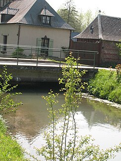
The hallue with bridge and mill in Fréchencourt |
||
| Data | ||
| Water code | FR : E6390700 | |
| location | France , Hauts-de-France region | |
| River system | Somme | |
| Drain over | Somme → English Channel | |
| source | in the municipality of Vadencourt 50 ° 0 '17 " N , 2 ° 29" 18 " E |
|
| Source height | approx. 56 m | |
| muzzle | in the municipality of Daours in a tributary of the Somme Coordinates: 49 ° 54 '13 " N , 2 ° 27' 16" E 49 ° 54 '13 " N , 2 ° 27' 16" E |
|
| Mouth height | approx. 27 m | |
| Height difference | approx. 29 m | |
| Bottom slope | approx. 1.8 ‰ | |
| length | 15.8 km | |
| Left tributaries | Ravin | |
| Right tributaries | Moulin | |
The Hallue is a small river in France that runs in the Somme department in the Hauts-de-France region . It rises on the southern outskirts of Vadencourt , generally drains southwest to south and flows after 15.8 kilometers on the western outskirts of Daours as a right tributary into a branch of the canalized Somme . Another estuary reaches it about 300 meters further downstream. In its course it forms numerous swamps and wetlands , on the banks there are also some poplar plantations . At its mouth it reaches a normal amount of water of around 1.45 cubic meters per second. In Fréchencourt, a still visible mill is evidence of its earlier use by watermills .
Places on the river
(Order in flow direction)
- Vadencourt
- Contay
- Beaucourt-sur-l'Hallue
- Montigny-sur-l'Hallue
- Fréchencourt
- Pont-Noyelles
- Querrieu
- Daours
history
The river achieved a certain prominence through the Battle of the Hallue on December 23, 1870, which took place here in the Franco-German War between the German Northern Army under General Manteuffel and the French Northern Army under General Faidherbe .
Web links
Individual evidence
- ↑ Source geoportail.gouv.fr
- ↑ estuary geoportail.gouv.fr
- ↑ a b The information on the length of the river is based on the information about the Halloue at SANDRE (French), accessed on November 6, 2013.
