Hammerbach (Hosewasch)
| Hammerbach | ||
|
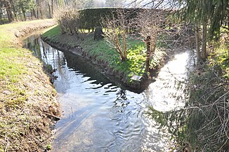
Union of Seebach and Hammerbach in the Nonner Unterland |
||
| Data | ||
| location | Bavaria , Germany | |
| River system | Salzach | |
| Drain over | Hosewasch → Saalach → Salzach → Inn → Danube → Black Sea | |
| source |
Listsee 47 ° 43 ′ 51 ″ N , 12 ° 51 ′ 34 ″ E |
|
| Source height | 640 m | |
| muzzle | in Nonner sub country to the pants washing coordinates: 47 ° 44 '27 " N , 12 ° 53' 10" O 47 ° 44 '27 " N , 12 ° 53' 10" O |
|
| Mouth height | 473 m | |
| Height difference | 167 m | |
| Bottom slope | 76 ‰ | |
| length | 2.2 km | |
| Small towns | Bad Reichenhall | |
The Hammerbach is an approx. 2.2 km long mountain stream, it rises on the Listsee in the Nonner Oberland at an altitude of 640 m, and then it flows in a steep gradient towards the Nonner Unterland, where it then at an altitude of 473 m in near the Hainbuchen Platz together with the Seebach forms the so-called Hosewasch .
