Hard brook
|
Hard brook Sörger brook |
||
|
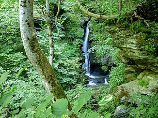
a waterfall on the Harter Bach, southwest of Sörg |
||
| Data | ||
| Water code | AT : 2-292-134-20-6 | |
| location | Carinthia , Austria | |
| River system | Danube | |
| Drain over | Feistritzbach → Glan → Gurk → Drau → Danube → Black Sea | |
| source | near Zojach in the Wimitzer mountains 46 ° 47 ′ 11 ″ N , 14 ° 12 ′ 8 ″ E |
|
| Source height | 1075 m above sea level A. | |
| muzzle | in Glantschach in the Feistritzbach Coordinates: 46 ° 44 '50 " N , 14 ° 16' 2" E 46 ° 44 '50 " N , 14 ° 16' 2" E |
|
| Mouth height | 574 m above sea level A. | |
| Height difference | 501 m | |
| Bottom slope | approx. 56 ‰ | |
| length | approx. 9 km | |
| Catchment area | 15.6 km² | |
| Left tributaries | Taumberger Bach, Grassendorfer Bach | |
| Communities | Liebenfels | |
The Harter Bach (also: Sörger Bach ) is a brook in central Carinthia . It rises in the Wimitzer Mountains near Zojach in the municipality of Liebenfels ( district of Sankt Veit an der Glan ) at an altitude of 1075 m. First of all, it flows in an east-southeast direction, with only a slight gradient in the area of the eponymous village of Hart and meandering strongly. Beginning with the natural monument Sörger waterfall , which has a fall height of 24 meters, the stream turns south and flows through a rocky, narrow and steep valley. In Glantschach it unites with the Liembergbach to the Feistritzbach .
The Adventure Waterway , a 7.5 km long hiking trail with several entry and exit options, runs along the creek between Hart and Glantschach .
The stream is in good to very good chemical and ecological condition.
Individual evidence
- ↑ a b KAGIS - Carinthia Atlas
- ^ A b Hydrographic Service in Austria (Hrsg.): Area directory of the Austrian river areas: Drau area. (Contributions to Austria's Hydrography, Issue No. 59) Vienna 2011, p. 80.
- ↑ Liebenfels community: Waterway folder (PDF)
- ^ Table of river status. P. 52. PDF
