
Zojach
|
Zojach ( Scattered Houses ) locality |
|||
|---|---|---|---|
|
|||
| Basic data | |||
| Pole. District , state | Sankt Veit an der Glan (SV), Carinthia | ||
| Judicial district | Sankt Veit an der Glan | ||
| Pole. local community | Liebenfels ( KG Sörgerberg ) | ||
| Coordinates | 46 ° 47 '19 " N , 14 ° 12' 46" E | ||
| height | 1130 m above sea level A. | ||
| Residents of the village | 36 (January 1, 2020) | ||
| Building status | 23 (January 1, 2011 ) | ||
| Statistical identification | |||
| Locality code | 01694 | ||
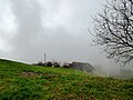
 Gasthof Wegscheide, Zojach |
|||
| Source: STAT : index of places ; BEV : GEONAM ; KAGIS | |||

Zojach is a village in the municipality of Liebenfels in the Sankt Veit an der Glan district in Carinthia . The village has 36 inhabitants (as of January 1, 2020). It lies entirely in the area of the Sörgerberg cadastral community .
In the first half of the 20th century, a building located in the neighboring cadastral community of Steinbichl was also considered to belong to the place, which at that time was divided into two communities (the community of Sörg , which later became part of the community of Liebenfels; and the community of Schaumboden , which later became part of the community Frauenstein rose) extended.
location
The village is located in the west of the Sankt Veit an der Glan district in the Wimitzer Mountains , on the slopes that descend from the ridge between Simonhöhe and Schneebauerberg to the south to the upper reaches of the Harter Bach , and - in the Wegscheide area - on the summit Mountain range. The village is accessible from Sörg via a narrow asphalt road ; there are unpaved road connections from other directions.
history
The place is mentioned in documents as Civviach in 1285 , which is derived from the Slovenian osojah (= with the shady sides ).
As part of the Sörgerberg tax community, the place belonged to the Gradenegg tax district in the first half of the 19th century . When the local congregations were formed in the course of the reforms after the revolution of 1848/49, Zojach came to the community of Glantschach , and in 1875 to the community of Sörg. Since the merger of the municipalities of Sörg and Liebenfels in 1973, the place has belonged to the municipality of Liebenfels.
Population development
The following population figures were counted for the place (unless otherwise mentioned, only in the area of today's town):
- 1869: 19 houses, 131 inhabitants
- 1880: 16 houses, 121 inhabitants
- 1890: 17 houses, 139 inhabitants
- 1900: 15 houses, 115 inhabitants
- 1910: 15 houses with 106 inhabitants and 1 house with 0 inhabitants in the area of the community of Schaumboden.
- 1923: 15 houses, 114 inhabitants and 1 house, 1 inhabitant in the area of the community of Schaumboden.
- 1934: 124 inhabitants
- 1961: 14 houses, 72 inhabitants
- 2001: 23 buildings (including 23 with main residence) with 24 apartments and 19 households; 63 residents and 5 cases of secondary residence
- 2011: 23 buildings, 48 inhabitants
There are 4 workplaces in the village (status 2011; 2001: 4) and 8 agricultural and forestry operations (status 2001).
Parts of the village
In the area of the locality, the local components Zojach and Wegscheide (at the crossroads in the extreme northwest of the cadastral community of Sörgerberg) were distinguished:
- 1961: Zojach 11 houses, 58 inhabitants; Cross 3 houses, 14 inhabitants
Zojach in the former municipality of Schaumboden
The portion of the village Zojach, which was reported in the former municipality of Schaumboden in 1910 and 1923, comprised only 1 house each. It was probably a building in the Wegscheide area directly on the municipality boundary, which the Frauenstein municipality, as the successor to the Schaumboden municipality, today regards as part of the Kreuth village .

Wegscheide sign

Divorce
Zojach No. 2 (Knieberger)

Zojach


Individual evidence
- ↑ Statistics Austria: Population on January 1st, 2020 by locality (area status on January 1st, 2020) , ( CSV )
- ^ Community Liebenfels (ed.): Community chronicle Liebenfels. 1998. p. 421.
- ^ Central Statistical Commission: Local Repertory of the Duchy of Carinthia. Based on the census of December 31, 1869. Carl Gerold's Sohn, Vienna 1872. P. 72.
- ↑ KK Statistische Central-Commission (Ed.): Complete list of localities of the kingdoms and countries represented in the Reichsrathe according to the results of the census of December 31, 1880. Alfred Hölder, Vienna 1882. P. 61.
- ↑ KK Statistische Central-Commission (Hrsg.): Local repertories of the kingdoms and countries represented in the Austrian Reichsrathe. Revised based on the results of the census of December 31, 1890. V. Carinthia. Alfred Hölder, Vienna 1894. p. 61.
- ↑ KK Central Statistical Commission (ed.): Community encyclopedia of the kingdoms and countries represented in the Reichsrat. Revised based on the results of the census of December 31, 1900. V. Carinthia. KK Hof- und Staatsdruckerei, Vienna 1905. p. 82.
- ^ Central Statistical Commission (ed.): Special locations repertory of the Austrian countries. Edited on the basis of the results of the census of December 31, 1910. V. Carinthia. Verlag der Staatsdruckerei, Vienna 1918. p. 43.
- ^ Federal Statistical Office (ed.): Directory of Austria. Edited on the basis of the results of the census of March 7, 1923. Österreichische Staatsdruckerei, Vienna 1930. Section Carinthia, p. 18.
- ↑ Handwritten addendum to the 1923 local directory (Federal Statistical Office (Hrsg.): Local directory of Austria. Edited on the basis of the results of the census of March 7, 1923. Österreichische Staatsdruckerei, Vienna 1930.) with the signature II 28238 of the Klagenfurt University Library. Section Carinthia, p. 18.
- ^ A b Austrian Central Statistical Office: Directory of Austria. Edited on the basis of the results of the census of March 21, 1961. Österreichische Staatsdruckerei, 1965. p. 257.
- ↑ a b c Statistics Austria (Ed.): Local directory 2001 Carinthia. Vienna 2004. 113.
- ^ A b Office of the Carinthian regional government, regional statistical office: Carinthian local directory. Territorial status January 1, 2014. Klagenfurt, 2014.

Cadastral communities: friendly | Glantschach | Gradenegg | Hardegg | Liebenfels | Liemberg | Pflausach | Rosenbichl | Rottschaft Feistritz | Sörg | Soergerberg
Locations: Bärndorf | Beißendorf | Harrows I | Harrows II | Friendly | Gasmai | Glantschach | Gßeberg | Dig | Gradenegg | Grassendorf | Reason | Hardegg | Hard | Hoch-Liebenfels | Hohenstein | Kraindorf | Kulm | Ladein | Lebmach | Liebenfels | Liemberg | Lorberhof | Mailsberg | Metschach | Miedling | Moss | Pflausach | Plowing | Pulse | Puppitsch | Radelsdorf | Rasting | Reidenau | Rohnsdorf | Rosenbichl | Sörg | Sörgerberg | St. Leonhard | Chadam | Waggendorf | Wasai | Weitensfeld | Woitsch | Zmuln | Zojach | Zwattendorf | Two churches
(Former) parts of the village: Grientschach | Undergrowth | Schoberhof | Seidelhof | Divorce
Counting district: Liebenfels-Nord | Liebenfels-Süd | Sörg
Former communities: Community of Glantschach 1850–1875 | Hardegg municipality 1850–1958 | Liemberg municipality 1850–1958 | Municipality of Pulst 1850–1958 (of which 1850–1875 as municipality of Feistritz ) | Municipality of Sörg 1875–1973