
Harrows I
|
Eggen I ( scattered houses ) locality |
|||
|---|---|---|---|
|
|||
| Basic data | |||
| Pole. District , state | Sankt Veit an der Glan (SV), Carinthia | ||
| Judicial district | Sankt Veit an der Glan | ||
| Pole. local community | Liebenfels ( KG cadastral community Liemberg ) | ||
| Coordinates | 46 ° 45 '21 " N , 14 ° 13' 45" O | ||
| height | 880 m above sea level A. | ||
| Residents of the village | 26 (January 1, 2020) | ||
| Building status | 13 (January 1, 2011 ) | ||
| Statistical identification | |||
| Locality code | 01462 | ||
| Source: STAT : index of places ; BEV : GEONAM ; KAGIS | |||

Eggen I is a village in the municipality of Liebenfels in the Sankt Veit an der Glan district in Carinthia . The village has 26 inhabitants (as of January 1, 2020). The village lies entirely within the territory of the Liemberg cadastral community .
location
The houses belonging to the village are located on a southern slope north of Liemberg , east of the Gößberg .
history
The place was first mentioned in 1285 ( sub Eke ); In 1423 he is mentioned in Ekhen (meaning: at the mountain corner ). In 1828 a part of the place - house numbers 1 to 3 - was called Ober-Eggen . When the political communities were created in the mid-19th century, Eggen became part of the Liemberg community , and when it was dissolved in 1958, it became part of the Liebenfels community. When in 1973 the municipality of Sörg , in whose area there was also a village called Eggen , was attached to the municipality of Liebenfels, there would have been two villages of the same name in one municipality. Therefore, since then, the name forms Eggen I have been used for the place described here that formerly belonged to the municipality of Liemberg and Eggen II for the place that was formerly part of the municipality of Sörg.
Population development
The following population figures were counted for the village:
- 1869: 15 houses, 75 inhabitants
- 1880: 14 houses, 54 inhabitants
- 1890: 11 houses, 52 inhabitants
- 1900: 11 houses, 49 inhabitants
- 1910: 12 houses, 61 inhabitants
- 1923: 11 houses, 65 inhabitants
- 1934: 53 inhabitants
- 1961: 7 houses, 38 inhabitants
- 2001: 13 buildings (including 13 with main residence) with 16 apartments and 15 households; 39 residents and 1 secondary residence case
- 2011: 13 buildings, 27 inhabitants
There is 1 workplace in the village (as of 2011; 2001: 1) and 8 agricultural and forestry businesses (as of 2001).

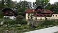
Inn in Eggen I
Eggen I House No. 9 with outbuilding
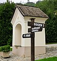
Signpost to Eggen I


Individual evidence
- ↑ Statistics Austria: Population on January 1st, 2020 by locality (area status on January 1st, 2020) , ( CSV )
- ^ Community Liebenfels (ed.): Community chronicle Liebenfels. 1998, p. 366.
- ^ Central Statistical Commission: Local Repertory of the Duchy of Carinthia. Based on the census of December 31, 1869. Carl Gerold's Sohn, Vienna 1872. P. 74.
- ↑ KK Statistische Central-Commission (Ed.): Complete list of localities of the kingdoms and countries represented in the Reichsrathe according to the results of the census of December 31, 1880. Alfred Hölder, Vienna 1882. S. 58.
- ↑ KK Statistische Central-Commission (Hrsg.): Local repertories of the kingdoms and countries represented in the Austrian Reichsrathe. Revised based on the results of the census of December 31, 1890. V. Carinthia. Alfred Hölder, Vienna 1894. p. 59.
- ↑ KK Central Statistical Commission (ed.): Community encyclopedia of the kingdoms and countries represented in the Reichsrat. Revised based on the results of the census of December 31, 1900. V. Carinthia. KK Hof- und Staatsdruckerei, Vienna 1905. p. 78.
- ^ Central Statistical Commission (ed.): Special locations repertory of the Austrian countries. Edited on the basis of the results of the census of December 31, 1910. V. Carinthia. Verlag der Staatsdruckerei, Vienna 1918. p. 40.
- ^ Federal Statistical Office (ed.): Directory of Austria. Edited on the basis of the results of the census of March 7, 1923. Österreichische Staatsdruckerei, Vienna 1930. Section Carinthia, p. 17.
- ↑ Handwritten addendum to the 1923 local directory (Federal Statistical Office (Hrsg.): Local directory of Austria. Edited on the basis of the results of the census of March 7, 1923. Österreichische Staatsdruckerei, Vienna 1930.) with the signature II 28238 of the Klagenfurt University Library. Section Carinthia, p. 17.
- ^ Austrian Central Statistical Office: Directory of Austria. Edited on the basis of the results of the census of March 21, 1961. Österreichische Staatsdruckerei, 1965. p. 256.
- ↑ a b c Statistics Austria (Ed.): Local directory 2001 Carinthia. Vienna 2004. 111.
- ^ A b Office of the Carinthian regional government, regional statistical office: Carinthian local directory. Territorial status January 1, 2014. Klagenfurt, 2014.

Cadastral communities: friendly | Glantschach | Gradenegg | Hardegg | Liebenfels | Liemberg | Pflausach | Rosenbichl | Rottschaft Feistritz | Sörg | Soergerberg
Locations: Bärndorf | Beißendorf | Harrows I | Harrows II | Friendly | Gasmai | Glantschach | Gßeberg | Dig | Gradenegg | Grassendorf | Reason | Hardegg | Hard | Hoch-Liebenfels | Hohenstein | Kraindorf | Kulm | Ladein | Lebmach | Liebenfels | Liemberg | Lorberhof | Mailsberg | Metschach | Miedling | Moss | Pflausach | Plowing | Pulse | Puppitsch | Radelsdorf | Rasting | Reidenau | Rohnsdorf | Rosenbichl | Sörg | Sörgerberg | St. Leonhard | Chadam | Waggendorf | Wasai | Weitensfeld | Woitsch | Zmuln | Zojach | Zwattendorf | Two churches
(Former) parts of the village: Grientschach | Undergrowth | Schoberhof | Seidelhof | Divorce
Counting district: Liebenfels-Nord | Liebenfels-Süd | Sörg
Former communities: Community of Glantschach 1850–1875 | Hardegg municipality 1850–1958 | Liemberg municipality 1850–1958 | Municipality of Pulst 1850–1958 (of which 1850–1875 as municipality of Feistritz ) | Municipality of Sörg 1875–1973