
Invite
|
Ladein ( scattered houses ) locality |
|||
|---|---|---|---|
|
|||
| Basic data | |||
| Pole. District , state | Sankt Veit an der Glan (SV), Carinthia | ||
| Judicial district | Sankt Veit an der Glan | ||
| Pole. local community | Liebenfels ( KG Freundsam ) | ||
| Coordinates | 46 ° 46 '9 " N , 14 ° 12' 47" E | ||
| height | 960 m above sea level A. | ||
| Residents of the village | 12 (January 1, 2020) | ||
| Building status | 6 (January 1, 2011 ) | ||
| Statistical identification | |||
| Locality code | 01686 | ||
 Ladein houses No. 5 and 6 |
|||
| Source: STAT : index of places ; BEV : GEONAM ; KAGIS | |||


Ladein is a village in the municipality of Liebenfels in the Sankt Veit an der Glan district in Carinthia . The village has 12 inhabitants (as of January 1, 2020). It lies entirely in the territory of the cadastral parish Freundsam .
location
The village is located in the southwest of the Sankt Veit an der Glan district and in the northwest of the Liebenfels municipality, on the slopes north of the Freundsamer Moos , only a few hundred meters east of the border between the Sankt Veit an der Glan and Feldkirchen districts.
history
The place was mentioned as Laedinen in 1285 . The place name should be derived from the Slovene Ledina (= unused meadow) or from the Romanic ( Latin ).
Located in the tax community of Freundsam, Ladein belonged to the tax district of Gradenegg in the first half of the 19th century . When the local congregations were founded in the course of the reforms after the revolution of 1848/49, Ladein first came to the Glantschach community , and in 1875 to the Sörg community . Through the merger of the municipalities of Sörg and Liebenfels in 1973, the village became part of the municipality of Liebenfels.
Population development
The following population figures were counted for the village:
- 1869: 4 houses, 29 inhabitants
- 1880: 4 houses, 28 inhabitants
- 1890: 4 houses, 39 inhabitants
- 1900: 5 houses, 32 inhabitants
- 1910: 5 houses, 25 inhabitants
- 1923: 5 houses, 23 inhabitants
- 1934: 33 inhabitants
- 1961: 5 houses, 18 inhabitants
- 2001: 6 buildings (including 6 with main residence) with 8 apartments and 4 households; 11 residents and 1 secondary residence case
- 2011: 6 buildings, 12 residents
In the village there is 1 workplace (status 2011; 2001: 0) and 1 agricultural and forestry operation (status 2001).
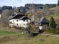
Ladein No. 5 and 6
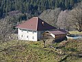
Ladein at No. 3

Ladein No. 2 and 3
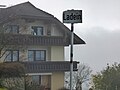
Place name sign Ladein, in the background number 6


Individual evidence
- ↑ Statistics Austria: Population on January 1st, 2020 by locality (area status on January 1st, 2020) , ( CSV )
- ^ Community Liebenfels (ed.): Community chronicle Liebenfels. 1998. p. 384.
- ^ Studia onomastica et indogermanica: Festschrift for Fritz Lochner von Hüttenbach on his 65th birthday. Leykam, 1995. p. 210.
- ^ Central Statistical Commission: Local Repertory of the Duchy of Carinthia. Based on the census of December 31, 1869. Carl Gerold's Sohn, Vienna 1872. P. 72.
- ^ KK Statistische Central-Commission (Ed.): Complete list of localities of the kingdoms and countries represented in the Reichsrathe according to the results of the census of December 31, 1880. Alfred Hölder, Vienna 1882. S. 60.
- ↑ KK Statistische Central-Commission (Hrsg.): Local repertories of the kingdoms and countries represented in the Austrian Reichsrathe. Revised based on the results of the census of December 31, 1890. V. Carinthia. Alfred Hölder, Vienna 1894. p. 61.
- ↑ KK Central Statistical Commission (ed.): Community encyclopedia of the kingdoms and countries represented in the Reichsrat. Revised based on the results of the census of December 31, 1900. V. Carinthia. KK Hof- und Staatsdruckerei, Vienna 1905. p. 82.
- ^ Central Statistical Commission (ed.): Special locations repertory of the Austrian countries. Edited on the basis of the results of the census of December 31, 1910. V. Carinthia. Verlag der Staatsdruckerei, Vienna 1918. p. 43.
- ^ Federal Statistical Office (ed.): Directory of Austria. Edited on the basis of the results of the census of March 7, 1923. Österreichische Staatsdruckerei, Vienna 1930. Section Carinthia, p. 18.
- ↑ Handwritten addendum to the 1923 local directory (Federal Statistical Office (Hrsg.): Local directory of Austria. Edited on the basis of the results of the census of March 7, 1923. Österreichische Staatsdruckerei, Vienna 1930.) with the signature II 28238 of the Klagenfurt University Library. Section Carinthia, p. 18.
- ^ Austrian Central Statistical Office: Directory of Austria. Edited on the basis of the results of the census of March 21, 1961. Österreichische Staatsdruckerei, 1965. p. 257.
- ↑ a b c Statistics Austria (Ed.): Local directory 2001 Carinthia. Vienna 2004. 112.
- ^ A b Office of the Carinthian regional government, regional statistical office: Carinthian local directory. Territorial status January 1, 2014. Klagenfurt, 2014.

Cadastral communities: friendly | Glantschach | Gradenegg | Hardegg | Liebenfels | Liemberg | Pflausach | Rosenbichl | Rottschaft Feistritz | Sörg | Soergerberg
Locations: Bärndorf | Beißendorf | Harrows I | Harrows II | Friendly | Gasmai | Glantschach | Gßeberg | Dig | Gradenegg | Grassendorf | Reason | Hardegg | Hard | Hoch-Liebenfels | Hohenstein | Kraindorf | Kulm | Ladein | Lebmach | Liebenfels | Liemberg | Lorberhof | Mailsberg | Metschach | Miedling | Moss | Pflausach | Plowing | Pulse | Puppitsch | Radelsdorf | Rasting | Reidenau | Rohnsdorf | Rosenbichl | Sörg | Sörgerberg | St. Leonhard | Chadam | Waggendorf | Wasai | Weitensfeld | Woitsch | Zmuln | Zojach | Zwattendorf | Two churches
(Former) parts of the village: Grientschach | Undergrowth | Schoberhof | Seidelhof | Divorce
Counting district: Liebenfels-Nord | Liebenfels-Süd | Sörg
Former communities: Community of Glantschach 1850–1875 | Hardegg municipality 1850–1958 | Liemberg municipality 1850–1958 | Municipality of Pulst 1850–1958 (of which 1850–1875 as municipality of Feistritz ) | Municipality of Sörg 1875–1973