
Friendly
|
Friendly ( scattered houses ) locality |
|||
|---|---|---|---|
|
|||
| Basic data | |||
| Pole. District , state | Sankt Veit an der Glan (SV), Carinthia | ||
| Judicial district | Sankt Veit an der Glan | ||
| Pole. local community | Liebenfels ( KG Freundsam ) | ||
| Coordinates | 46 ° 45 '55 " N , 14 ° 13' 54" E | ||
| height | 980 m above sea level A. | ||
| Residents of the village | 34 (January 1, 2020) | ||
| Building status | 16 (January 1, 2011 ) | ||
| Statistical identification | |||
| Locality code | 01680 | ||
 Freundsam branch church and Freundsam house No. 5, location of the former Freundsam Castle |
|||
| Source: STAT : index of places ; BEV : GEONAM ; KAGIS | |||

Freundsam is a village in the municipality of Liebenfels in the Sankt Veit an der Glan district in Carinthia . The village has 34 inhabitants (as of January 1, 2020). Today the village lies entirely in the territory of the cadastral parish Freundsam ; Until the turn of the 20th century, however, the Rotte Unterholz, located in the area of the neighboring cadastral community Gradenegg , was also considered part of the village of Freundsam.
location
The village is located in the southwest of the Sankt Veit an der Glan district, on a southern slope east of the Freundsamer Moos and northwest of Gradenegg . It includes, among others, the courts Leitner , Lattmanig , Silbernig and Schlossbauer , which is the former Meierhof next to the castle ruins Gradenegg .
history
Gradenegg Castle is mentioned from the end of the 12th century. The place Freundsam is mentioned in 1245 as Vreundesheim . In 1304 the Freundsam Church , a branch church of the Gradenegg parish, is mentioned for the first time. The Freundsam Castle was located next to the church, but it fell into disrepair early and today there are no more ruins. The Silbernig farm , whose name comes from silver mining, is mentioned from the 15th century .
In the first half of the 19th century, the place belonged to the tax district of Gradenegg as part of the tax community Freundsam . When the local congregations were founded after the 1848/49 revolution, the village was first part of the Glantschach community and then in 1875 to the Sörg community , and when they were merged with the Liebenfels community in 1973 to the Liebenfels community.
Population development
The following population figures were counted for the village:
- 1869: 20 houses, 140 inhabitants (initially including undergrowth )
- 1880: 15 houses, 120 inhabitants
- 1890: 14 houses, 155 inhabitants
- 1900: 15 houses, 161 inhabitants
- 1910: 11 houses, 92 inhabitants (without undergrowth, which was now included in the village of Gradenegg )
- 1923: 9 houses, 73 inhabitants
- 1934: 77 inhabitants
- 1961: 10 houses, 70 inhabitants
- 2001: 14 buildings (14 of them with main residence) with 15 apartments and 13 households; 37 residents and 0 cases of secondary residence
- 2011: 16 buildings, 44 inhabitants
There are 0 workplaces in the village (status 2011; 2001: 0) and 8 agricultural and forestry operations (status 2001).
Personalities
- Hermann Göschler, born on February 20, 1915 in Freundsam Nr. 2, executed on December 1, 1939 in Berlin-Plötzensee as a conscientious objector to military service ( Jehovah's Witness )

Affiliate church Freundsam
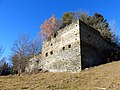
Gradenegg castle ruins

Hermann Göschler, mentioned at the Klagenfurt-Annabichl memorial for Nazi victims
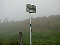
Place name sign Freundsam
Village sign (at that time still part of the municipality of Sörg)
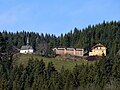
Church and house number 9


Individual evidence
- ↑ Statistics Austria: Population on January 1st, 2020 by locality (area status on January 1st, 2020) , ( CSV )
- ^ Community Liebenfels (ed.): Community chronicle Liebenfels. 1998, p. 366.
- ^ Central Statistical Commission: Local Repertory of the Duchy of Carinthia. Based on the census of December 31, 1869. Carl Gerold's Sohn, Vienna 1872. P. 72.
- ^ KK Statistische Central-Commission (Ed.): Complete list of localities of the kingdoms and countries represented in the Reichsrathe according to the results of the census of December 31, 1880. Alfred Hölder, Vienna 1882. S. 60.
- ↑ KK Statistische Central-Commission (Hrsg.): Local repertories of the kingdoms and countries represented in the Austrian Reichsrathe. Revised based on the results of the census of December 31, 1890. V. Carinthia. Alfred Hölder, Vienna 1894. p. 61.
- ↑ KK Central Statistical Commission (ed.): Community encyclopedia of the kingdoms and countries represented in the Reichsrat. Revised based on the results of the census of December 31, 1900. V. Carinthia. KK Hof- und Staatsdruckerei, Vienna 1905. p. 82.
- ^ Central Statistical Commission (ed.): Special locations repertory of the Austrian countries. Edited on the basis of the results of the census of December 31, 1910. V. Carinthia. Verlag der Staatsdruckerei, Vienna 1918. p. 43.
- ^ Federal Statistical Office (ed.): Directory of Austria. Edited on the basis of the results of the census of March 7, 1923. Österreichische Staatsdruckerei, Vienna 1930. Section Carinthia, p. 18.
- ↑ Handwritten addendum to the 1923 local directory (Federal Statistical Office (Hrsg.): Local directory of Austria. Edited on the basis of the results of the census of March 7, 1923. Österreichische Staatsdruckerei, Vienna 1930.) with the signature II 28238 of the Klagenfurt University Library. Section Carinthia, p. 18.
- ^ Austrian Central Statistical Office: Directory of Austria. Edited on the basis of the results of the census of March 21, 1961. Österreichische Staatsdruckerei, 1965. p. 257.
- ↑ a b c Statistics Austria (Ed.): Local directory 2001 Carinthia. Vienna 2004. 111.
- ^ A b Office of the Carinthian regional government, regional statistical office: Carinthian local directory. Territorial status January 1, 2014. Klagenfurt, 2014.
- ↑ club Purple Triangles: Göschler Hermann

Cadastral communities: friendly | Glantschach | Gradenegg | Hardegg | Liebenfels | Liemberg | Pflausach | Rosenbichl | Rottschaft Feistritz | Sörg | Soergerberg
Locations: Bärndorf | Beißendorf | Harrows I | Harrows II | Friendly | Gasmai | Glantschach | Gßeberg | Dig | Gradenegg | Grassendorf | Reason | Hardegg | Hard | Hoch-Liebenfels | Hohenstein | Kraindorf | Kulm | Ladein | Lebmach | Liebenfels | Liemberg | Lorberhof | Mailsberg | Metschach | Miedling | Moss | Pflausach | Plowing | Pulse | Puppitsch | Radelsdorf | Rasting | Reidenau | Rohnsdorf | Rosenbichl | Sörg | Sörgerberg | St. Leonhard | Chadam | Waggendorf | Wasai | Weitensfeld | Woitsch | Zmuln | Zojach | Zwattendorf | Two churches
(Former) parts of the village: Grientschach | Undergrowth | Schoberhof | Seidelhof | Divorce
Counting district: Liebenfels-Nord | Liebenfels-Süd | Sörg
Former communities: Community of Glantschach 1850–1875 | Hardegg municipality 1850–1958 | Liemberg municipality 1850–1958 | Municipality of Pulst 1850–1958 (of which 1850–1875 as municipality of Feistritz ) | Municipality of Sörg 1875–1973